
Auburndale, Florida facts for kids
Quick facts for kids
Auburndale, Florida
|
|
|---|---|
| City of Auburndale | |

The historic Auburndale City Hall as seen in June 2009.
|
|

Location of Auburndale in Polk County, Florida.
|
|
| Country | United States of America |
| State | Florida |
| County | Polk |
| Settled | 1880 |
| Incorporated | 1911 |
| Area | |
| • Total | 20.58 sq mi (53.30 km2) |
| • Land | 13.56 sq mi (35.12 km2) |
| • Water | 7.02 sq mi (18.19 km2) |
| Elevation | 141 ft (43 m) |
| Population
(2020)
|
|
| • Total | 15,616 |
| • Estimate
(2023)
|
20,011 |
| • Density | 1,151.79/sq mi (444.70/km2) |
| Time zone | UTC-5 (Eastern (EST)) |
| • Summer (DST) | UTC-4 (EDT) |
| ZIP code |
33823
|
| Area code(s) | 863 |
| FIPS code | 12-02550 |
| GNIS feature ID | 2403135 |
| Website | http://www.auburndalefl.com |
Auburndale is a city in Polk County, Florida, United States. In 2020, about 15,616 people lived there. It is part of a larger area called the Lakeland-Winter Haven, Florida Metropolitan Statistical Area.
Contents
Discovering Auburndale's Past
Auburndale was started in 1880 by Frank Fuller. He wanted to escape the cold winters in the Northeast United States. The place was first called Sanatoria, named after a hotel there.
When the railroad arrived in the 1880s, the town got a new name. Settlers from Auburndale, Massachusetts suggested calling it Auburndale. That New England town was named after a line in a poem by Oliver Goldsmith. Early on, many famous artists chose Auburndale as a place to visit.
Geography and Climate of Auburndale
Auburndale is located in central Florida. It is about 40 miles (64 km) northeast of Tampa. It's also about 59 miles (95 km) southwest of Orlando. The area has flat land with some gently rolling hills.
Land and Water
The city covers a total area of about 9.3 square miles (24.1 square kilometers). A large part of this area is water. About 5.2 square miles (13.5 square kilometers) is land. The remaining 4.1 square miles (10.6 square kilometers), or about 44%, is water.
Weather in Auburndale
Auburndale has a humid subtropical climate. This means it has hot, humid summers and mild winters. It's a common climate type for Florida.
People of Auburndale
| Historical population | |||
|---|---|---|---|
| Census | Pop. | %± | |
| 1920 | 715 | — | |
| 1930 | 1,849 | 158.6% | |
| 1940 | 2,723 | 47.3% | |
| 1950 | 3,763 | 38.2% | |
| 1960 | 5,595 | 48.7% | |
| 1970 | 5,386 | −3.7% | |
| 1980 | 6,501 | 20.7% | |
| 1990 | 8,858 | 36.3% | |
| 2000 | 11,032 | 24.5% | |
| 2010 | 13,507 | 22.4% | |
| 2020 | 15,616 | 15.6% | |
| 2023 (est.) | 20,011 | 48.2% | |
| U.S. Decennial Census | |||
Population Changes (2010 and 2020)
The city's population grew from 13,507 people in 2010 to 15,616 people in 2020. This shows that more people are choosing to live in Auburndale.
In 2020, there were 15,616 people living in Auburndale. These people lived in 5,141 households. About 3,701 of these were families.
| Race | Pop 2010 | Pop 2020 | % 2010 | % 2020 |
|---|---|---|---|---|
| White (NH) | 9,679 | 9,709 | 71.66% | 62.17% |
| Black or African American (NH) | 1,677 | 1,908 | 12.42% | 12.22% |
| Native American or Alaska Native (NH) | 24 | 64 | 0.18% | 0.41% |
| Asian (NH) | 154 | 256 | 1.14% | 1.64% |
| Pacific Islander or Native Hawaiian (NH) | 0 | 7 | 0.00% | 0.04% |
| Some other race (NH) | 17 | 59 | 0.13% | 0.38% |
| Two or more races/Multiracial (NH) | 185 | 693 | 1.37% | 4.44% |
| Hispanic or Latino (any race) | 1,771 | 2,920 | 13.11% | 18.70% |
| Total | 13,507 | 15,616 | 100% | 100% |
Getting Around Auburndale
Auburndale has several important roads and ways to travel.
Major Roads
 I-4 - This is a major highway in central Florida. It goes west to Lakeland and Tampa. Eastward, it leads to Orlando and Daytona Beach.
 SR 570 (Polk Parkway) - This is a toll road. It helps people in Auburndale quickly get to I-4. It also goes west to southern Lakeland.
 US 92 - This highway goes west to Lakeland and east to Lake Alfred.
 SR 544 - This road goes from eastern Auburndale to Winter Haven. It is also known as Havendale Boulevard.
 SR 559 - This road leads to Polk City and I-4.
Public Transportation
Auburndale has bus services provided by Winter Haven Area Transit. These are routes #12 and #50.
Trains and Airports
Railroads are also important here. Auburndale has two main railroad lines: the CSX Carters Subdivision and the CSX Auburndale Subdivision. Amtrak trains use these lines, but they do not stop in Auburndale.
For air travel, two airports serve Auburndale. Both are located in Winter Haven, east of the city. They are the Winter Haven Regional Airport and the Jack Browns Seaplane Base. The seaplane base is on the northeast side of Lake Jessie.
Media and News
Auburndale is part of the Tampa/St. Pete television market. This is one of the largest TV markets in the country. The city is also part of the local Lakeland/Winter Haven radio market.
Auburndale Public Library
The Auburndale Public Library is a part of the Polk County Library Cooperative. It is located at 100 West Bridgers Avenue, Auburndale, Florida 33823. The library offers many services to all residents of Polk County. This includes access to their online catalog 24 hours a day.
Education in Auburndale
Public schools in Auburndale are managed by the Polk County School Board.
Elementary Schools
There are five elementary schools:
- Berkley Elementary (a charter school)
- Auburndale Central Elementary
- Lena Vista Elementary
- Boswell Elementary
- Caldwell Elementary
These elementary schools usually send their students to Stambaugh Middle School. Students from Berkley Elementary can go to Berkley Accelerated Middle School, which is another charter school. Other students can apply to Berkley Accelerated Middle School, but they might be put on a waiting list.
High Schools
The main high schools in Auburndale are Auburndale High School and Polk Pre-Collegiate Academy (PPCA). Also, Tenoroc High School is nearby and serves students from both Auburndale and Lakeland.
Colleges and Universities
Southern Technical College has a campus in Auburndale. Close by, in Lakeland, Florida, is the main campus of Florida Polytechnic University.
Images for kids
-
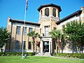
The historic Auburndale City Hall as seen in June 2009.
-
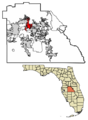
Location of Auburndale in Polk County, Florida.
See also
 In Spanish: Auburndale (Florida) para niños
