Augustine Heights, Queensland facts for kids
Quick facts for kids Augustine HeightsIpswich, Queensland |
|||||||||||||||
|---|---|---|---|---|---|---|---|---|---|---|---|---|---|---|---|

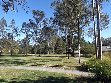
Park along Christopher Street, 2016
|
|||||||||||||||
| Population | 6,088 (2021 census) | ||||||||||||||
| • Density | 1,194/km2 (3,090/sq mi) | ||||||||||||||
| Established | 19 September 2003 | ||||||||||||||
| Postcode(s) | 4300 | ||||||||||||||
| Area | 5.1 km2 (2.0 sq mi) | ||||||||||||||
| Time zone | AEST (UTC+10:00) | ||||||||||||||
| Location |
|
||||||||||||||
| LGA(s) | City of Ipswich | ||||||||||||||
| State electorate(s) | Jordan | ||||||||||||||
| Federal Division(s) | Blair | ||||||||||||||
|
|||||||||||||||
Augustine Heights is a suburb located in the city of Ipswich, in Queensland, Australia. It's a place where over 6,000 people live.
Contents
History of Augustine Heights
Augustine Heights is part of a bigger area called Greater Springfield. This is Australia's largest "master-planned community." This means the whole area was carefully designed and built from scratch.
Augustine Heights was officially named on September 19, 2003.
Schools and Churches
St Augustine's College opened its doors on January 29, 2003. A special event happened on July 28, 2003. A Catholic church called St Stephen's was moved from Laravale to the college. It is now known as St Monica's Chapel. This chapel is used by the school and by the local community.
The original St Stephen's church was first opened in Laravale on February 18, 1923. Archbishop James Duhig was there with 400 people. St Augustine's College was officially opened and blessed by Archbishop John Battersby on August 31, 2003.
Augusta State School opened on January 1, 2011. It was first going to be called Augustine Heights State School. A new school, Woogaroo Creek State School, also opened in January 2023.
People Living in Augustine Heights
The number of people living in Augustine Heights has grown over time. In 2016, about 4,880 people lived here. By 2021, the population had grown to 6,088 people.
Education in Augustine Heights
Augustine Heights has several schools for students of all ages.
Primary Schools
- Augusta State School is a government primary school. It teaches students from Early Childhood (Prep) up to Year 6. You can find it at 60-100 Brittains Road. In 2018, the school had over 1,000 students. It also has a special education program for students who need extra support.
- Woogaroo Creek State School is another primary school. It is located at 12 Purser Road.
Primary and Secondary School
- St Augustine's College is a Catholic school. It teaches students from Prep all the way through to Year 12. This means students can go to the same school for their entire education. It is located on St Augustine's Drive. In 2018, more than 1,400 students attended this college.
Secondary Schools Nearby
There are no government high schools right inside Augustine Heights. The closest government high school for students is Redbank Plains State High School. It is in the nearby suburb of Redbank Plains.
 | Misty Copeland |
 | Raven Wilkinson |
 | Debra Austin |
 | Aesha Ash |


