
Aurukun, Queensland facts for kids
Quick facts for kids AurukunQueensland |
|
|---|---|

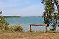
2014
|
|

Aurukun
Location in Queensland
|
|
| Population | 1,101 (2021 census) |
| • Density | 0.14863/km2 (0.3849/sq mi) |
| Postcode(s) | 4892 |
| Area | 7,407.7 km2 (2,860.1 sq mi) |
| Time zone | AEST (UTC+10:00) |
| Location | |
| LGA(s) |
|
| County | Kendell County, Queensland |
| State electorate(s) | Cook |
| Federal Division(s) | Leichhardt |
Aurukun /ærəˈkuːn/ is a town and coastal area in Far North Queensland, Australia. It is an Indigenous community. In the 2021 census, Aurukun had a population of 1,101 people. Most residents, about 88.7%, identify as Aboriginal or Torres Strait Islander people.
Contents
Where is Aurukun?
Aurukun is located about 100 kilometres (62 mi) south of Weipa. The town faces west towards the Gulf of Carpentaria. During the wet season, roads in the area can be very difficult to travel on. The land around Aurukun is rich in a mineral called bauxite.
A Look at Aurukun's History

The Kugu Mu'inh language is a traditional language of this area. The first time Europeans met Aboriginal Australians here was during the Janszoon voyage of 1605–06.
A Christian Mission was set up in Aurukun on 4 August 1904. It was run by the Presbyterian Church of Australia. Aboriginal people from the surrounding areas came to live at the mission. For 40 years, Reverend William Mackenzie was in charge of the mission. Aurukun once had a cattle station, a sawmill, a butcher, and a bakery. The town was later named Aurukun, which is an Aboriginal name for a lagoon on the Watson River.

Children at the mission lived in dormitories but could visit their families during holidays. Young adults were trained for different jobs.
Aurukun Post Office opened on 1 July 1972.
Wik woman Alison Woolla was the first female mayor of Aurukun. She served from 1983 to 1985 and again from 1991 to 1994. She helped create a women's shelter in the community. An award was named after her in 2020 to honor her work.

In 1978, the Queensland government planned to take over running the Aurukun mission. The community did not want this and asked the Federal government for help. After talks, a law was passed to allow the community to manage itself. This law, called the Aboriginal and Torres Strait Islanders (Queensland Reserves and Communities Self Management) Act 1978, came into effect on 7 April 1978. Later, the Local Government (Aboriginal Lands) Act 1978 gave a 50-year lease to the Shire of Aurukun. This meant an elected Aboriginal Council would manage the land. Aurukun and Mornington Shire are the only Aboriginal communities in Queensland that are also local government areas.
After a court decision in 1996, the land became native title land held by the Wik people. Most Wik people still live in this area.
Aurukun in the 21st Century
In 2008, there were concerns about education and safety in Aurukun. The community worked to improve these areas.
Aurukun is home to many different Aboriginal groups. As of As of 2013[update], there were about 50 to 60 families from five main clan groups living there.
In January 2020, a challenging event occurred in Aurukun. It led to some houses being burned down. Many residents temporarily left the town for safety. Some went to nearby bushland, and others traveled to Coen. The community worked to recover from this event.
In July 2020, the Alison Woolla Memorial Award was created. It recognizes people who help prevent family violence.
Population Information
In the 2016 census, Aurukun had 1,269 people. Most of them (1,147) were Aboriginal and Torres Strait Islander people. About 95.8% of people were born in Australia. While 10.6% spoke only English at home, many also spoke Cape York Peninsula languages (61.6%) and Wik Mungkan (14.7%).
In the 2021 census, the population was 1,101 people. Of these, 997 (88.7%) identified as Aboriginal or Torres Strait Islander people.
Education in Aurukun
Aurukun has a primary school for students from pre-prep to year 7. It opened on 29 January 1974. The school teaches English literacy and math using a method called Direct Instruction. This method focuses on helping each student learn basics through repetition and weekly tests. Students also learn about Indigenous culture and language. The school has an extended day with art, music, and sports programs. These programs help children gain confidence and prepare for life outside the community.
In 2008, school attendance was low, but it improved after new programs were introduced. In May 2016, the school had to close temporarily due to safety concerns for teachers. Distance learning continued during this time. The Queensland Government is now adding the Australian curriculum to the school alongside Direct Instruction.
Town Services and Facilities
Utilities
Electricity in Aurukun comes from diesel generators. The town has a good water supply from five bores. Since October 2014, fluoride has been added to the water. There is also a sewer system. In 2011 and 2012, the water and sewer systems were greatly improved.
In 2007, it was reported that few people in Aurukun had phones. The community also uses radio towers for communication services, as there is no ADSL broadband.
Security
Aurukun is a closely watched community. In 2008, 34 security cameras were put up around the town. These cameras cover most areas and are watched from Cairns. This system is much cheaper than hiring a private security company.
What to Do in Aurukun
The Wik and Kugu Art Centre in Aurukun opened in 1987. It is the oldest art center on the Cape York Peninsula. About 30 artists are part of the center. Their art, especially sculptures made from soft woods, is known worldwide.
The Aurukun Shire Council runs the Wik Mungkan Indigenous Knowledge Centre.
Aurukun has a community swimming pool and a large basketball hall. There are also outdoor basketball courts and a rugby field. Aurukun teams often play in football and softball games with other communities in the Cape region.
The Aurukun Uniting Church is located at 502 Kang Kang Street.
Places to Visit
Visitors to Aurukun enjoy bushwalking, fishing, and camping. You need to get a permit from the Aurukun Shire Council before visiting the community.
- Possum Creek is a swimming hole about 30 kilometres (19 mi) west of town.
- Sandy Creek is another swimming hole, about 40 kilometres (25 mi) from Possum Creek.
- Emu Creek is a 4WD track.
- Aurukun landing is 1.5 kilometres (0.93 mi) from town. It gives access to the Archer River, but be aware that crocodiles are present.
- Umban is a 4WD camping ground, just under 2 hours' drive away.
Images for kids
-
2014
-
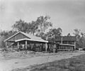
Aurukun sawmill, circa 1950
-
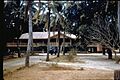
Superintendent's residence at Aurukun, circa 1959-1960
-
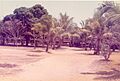
Aurukun Presbyterian Mission House, October 1973
See Also
