Bacon County, Georgia facts for kids
Quick facts for kids
Bacon County
|
||
|---|---|---|

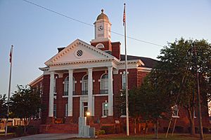
Bacon County Courthouse in Alma
|
||
|
||

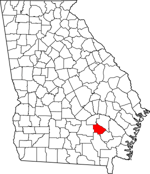
Location within the U.S. state of Georgia
|
||
 Georgia's location within the U.S. |
||
| Country | ||
| State | ||
| Founded | July 27, 1914 | |
| Named for | Augustus Octavius Bacon | |
| Seat | Alma | |
| Largest city | Alma | |
| Area | ||
| • Total | 286 sq mi (740 km2) | |
| • Land | 259 sq mi (670 km2) | |
| • Water | 27 sq mi (70 km2) 9.5%% | |
| Population
(2020)
|
||
| • Total | 11,140 | |
| • Density | 43/sq mi (17/km2) | |
| Time zone | UTC−5 (Eastern) | |
| • Summer (DST) | UTC−4 (EDT) | |
| Congressional district | 1st | |
Bacon County is a county located in the southeastern part of the U.S. state of Georgia. As of the 2020 census, about 11,140 people lived there. The main town and county seat is Alma.
Contents
History of Bacon County
Bacon County was officially created on July 27, 1914. This happened after a special change to the state's rules was approved. The county is named after Augustus Octavius Bacon. He was an important person who served as a United States senator from Georgia.
Geography of Bacon County
Bacon County covers a total area of about 286 square miles. Most of this area, about 259 square miles, is land. The rest, about 27 square miles, is water. This means about 9.5% of the county is covered by water.
The western part of Bacon County is in the Satilla River area. This river flows into the St. Marys River. The eastern side of the county is in the Little Satilla River area. This river also flows into the St. Marys River. Bacon County is part of Southeast Georgia.
Main Roads in Bacon County
 U.S. Route 1
 U.S. Route 23
 Georgia State Route 4
 State Route 4 Alternate
 State Route 19
 State Route 32
 State Route 203
Neighboring Counties
Bacon County shares borders with these other counties:
- Appling County (to the northeast)
- Pierce County (to the southeast)
- Ware County (to the south)
- Coffee County (to the west)
- Jeff Davis County (to the northwest)
Towns and Communities
City
- Alma (This is the main town and where the county government is located.)
Other Communities
People of Bacon County
In 1920, Bacon County had a population of 6,460 people. The number of people living in the county has generally grown over the years. However, there were small drops in population in 1960 and 1970.
By the 2020 United States census, the population reached 11,140 people. There were 3,874 households and 2,706 families living in the county. Most people in Bacon County are White (about 72.74%). A smaller group is Black or African American (about 15.68%). Other groups include Asian, Native American, and Pacific Islander people. About 7.85% of the population is Hispanic or Latino.
In 2022, the average income for a household in Bacon County was about $43,938 per year. The average income per person was about $24,654. About 21.6% of the people in the county lived below the poverty line. Most homes in the county (72%) are owned by the people who live in them. The average value of an owned home was about $95,600.
Many people in Bacon County are Christian. The largest religious group is the Southern Baptist Convention. Other Christian groups include the Church of God, the Church of Jesus Christ of Latter-day Saints, and Free Will Baptists. Methodists, Holiness, and Pentecostal Christians also live in the county.
Education in Bacon County
See also
 In Spanish: Condado de Bacon para niños
 | Jewel Prestage |
 | Ella Baker |
 | Fannie Lou Hamer |


