Baconton, Georgia facts for kids
Quick facts for kids
Baconton, Georgia
|
|
|---|---|
| Motto(s): | |

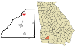
Location in Mitchell County and the state of Georgia
|
|
| Country | United States |
| State | Georgia |
| County | Mitchell |
| Area | |
| • Total | 1.95 sq mi (5.05 km2) |
| • Land | 1.95 sq mi (5.05 km2) |
| • Water | 0.00 sq mi (0.00 km2) |
| Elevation | 174 ft (53 m) |
| Population
(2020)
|
|
| • Total | 856 |
| • Density | 438.52/sq mi (169.34/km2) |
| Time zone | UTC-5 (Eastern (EST)) |
| • Summer (DST) | UTC-4 (EDT) |
| ZIP code |
31716
|
| Area code(s) | 229 |
| FIPS code | 13-04840 |
| GNIS feature ID | 0331077 |
Baconton is a small city in Mitchell County, Georgia, in the United States. It is a quiet place where people live and go to school. In 2020, about 856 people lived there. This number was a little lower than the 915 people who lived there in 2010.
Contents
History of Baconton
Baconton became an official city in 1903. The community was named after a man called Major Robert James Bacon. He was one of the first owners of the land where the town was built.
Geography of Baconton
Baconton is located in the northern part of Mitchell County. It covers about 2 square miles (5 square kilometers) of land. U.S. Route 19 runs along the eastern edge of the city. This road can take you south about 10 miles (16 km) to Camilla, which is the county seat. It can also take you north about 16 miles (26 km) to Albany.
The Flint River flows about one mile (1.6 km) to the west of Baconton. The soil in Baconton is usually well-drained. It has grayish-brown sandy topsoil. Underneath this, there is yellowish-brown or red sandy clay. These soils are good for growing plants. Where there are no farms or buildings, you can find mixed forests. These forests have many pines and oaks.
Population Facts
Demographics are facts about a population. They tell us things like how many people live somewhere. They also show their ages or backgrounds. Here is how Baconton's population has changed over the years:
| Historical population | |||
|---|---|---|---|
| Census | Pop. | %± | |
| 1910 | 391 | — | |
| 1920 | 568 | 45.3% | |
| 1930 | 498 | −12.3% | |
| 1940 | 504 | 1.2% | |
| 1950 | 500 | −0.8% | |
| 1960 | 564 | 12.8% | |
| 1970 | 710 | 25.9% | |
| 1980 | 763 | 7.5% | |
| 1990 | 623 | −18.3% | |
| 2000 | 804 | 29.1% | |
| 2010 | 915 | 13.8% | |
| 2020 | 856 | −6.4% | |
| U.S. Decennial Census 1850-1870 1870-1880 1890-1910 1920-1930 1940 1950 1960 1970 1980 1990 2000 2010 |
|||
People Living in Baconton (2020)
In 2020, there were 856 people living in Baconton. These people lived in 335 households. About 288 of these households were families.
| Race | Num. | Perc. |
|---|---|---|
| White (non-Hispanic) | 338 | 39.49% |
| Black or African American (non-Hispanic) | 479 | 55.96% |
| Native American | 2 | 0.23% |
| Asian | 5 | 0.58% |
| Other/Mixed | 26 | 3.04% |
| Hispanic or Latino | 6 | 0.7% |
Education in Baconton
The Mitchell County School District helps educate students in Baconton. It also serves students in Camilla.
Schools in Baconton
- Public Schools
- North Mitchell County Elementary School
- Charter Schools
- Baconton Community Charter Schools
See also
 In Spanish: Baconton para niños


