Baracoa facts for kids
Quick facts for kids
Baracoa
|
|
|---|---|

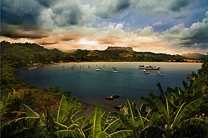
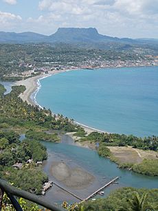
A view of Baracoa across the bay
|
|
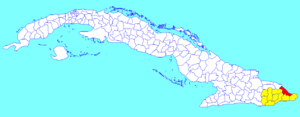
Baracoa municipality (red) within
Guantánamo Province (yellow) and Cuba |
|
| Country | Cuba |
| Province | Guantánamo |
| Established | 1511 |
| Area | |
| • Total | 977 km2 (377 sq mi) |
| Elevation | 5 m (16 ft) |
| Population
(2004)
|
|
| • Total | 81,794 |
| • Density | 83.7/km2 (217/sq mi) |
| Time zone | UTC-5 (EST) |
| Area code(s) | +53-21 |
Baracoa is a city and municipality located in Guantánamo Province, at the eastern end of Cuba. Its full original name was Nuestra Señora de la Asunción de Baracoa. This means "Our Lady of the Assumption of Baracoa".
The famous explorer Christopher Columbus visited this area on November 27, 1492. Later, on August 15, 1511, the first Spanish governor of Cuba, Diego Velázquez de Cuéllar, officially founded the city. Baracoa is the oldest Spanish settlement in Cuba. It was also Cuba's first capital city, which is why it's nicknamed Ciudad Primada, meaning "First City".
Contents
Geography of Baracoa
Baracoa is located where Christopher Columbus first landed in Cuba. The name "Baracoa" is thought to come from an old local language. It means "the presence of the sea".
The city sits on the Bay of Honey (Bahía de Miel). It is surrounded by tall mountain ranges, like the Sierra del Purial. These mountains make Baracoa quite isolated. There is only one main mountain road, built in the 1960s, that connects it to other areas. The mountains around Baracoa are covered with thick forests. These include Cuban moist forests and Cuban pine forests.
The municipality of Baracoa includes several smaller villages. Some of these are Barigua, Boca de Yumurí, and Jamal.
Baracoa's Climate
Baracoa has a tropical rainforest climate. This means it has high temperatures and lots of rain all year round. While there isn't a clear wet or dry season, it tends to rain more from October to December.
| Climate data for Baracoa | |||||||||||||
|---|---|---|---|---|---|---|---|---|---|---|---|---|---|
| Month | Jan | Feb | Mar | Apr | May | Jun | Jul | Aug | Sep | Oct | Nov | Dec | Year |
| Mean daily maximum °C (°F) | 28.3 (82.9) |
27.5 (81.5) |
28.6 (83.5) |
29.7 (85.5) |
30.5 (86.9) |
31.6 (88.9) |
31.8 (89.2) |
32.2 (90.0) |
31.9 (89.4) |
31.1 (88.0) |
29.2 (84.6) |
28.1 (82.6) |
30.0 (86.1) |
| Daily mean °C (°F) | 24.2 (75.6) |
23.3 (73.9) |
24.2 (75.6) |
25.5 (77.9) |
26.4 (79.5) |
27.3 (81.1) |
27.7 (81.9) |
27.9 (82.2) |
27.5 (81.5) |
26.8 (80.2) |
25.3 (77.5) |
24.3 (75.7) |
25.9 (78.6) |
| Mean daily minimum °C (°F) | 20.2 (68.4) |
19.2 (66.6) |
19.9 (67.8) |
21.3 (70.3) |
22.4 (72.3) |
23.1 (73.6) |
23.6 (74.5) |
23.7 (74.7) |
23.2 (73.8) |
22.5 (72.5) |
21.5 (70.7) |
20.5 (68.9) |
21.8 (71.2) |
| Average rainfall mm (inches) | 218 (8.6) |
143 (5.6) |
141 (5.6) |
147 (5.8) |
284 (11.2) |
168 (6.6) |
186 (7.3) |
196 (7.7) |
186 (7.3) |
356 (14.0) |
334 (13.1) |
342 (13.5) |
2,701 (106.3) |
| Source: Climate-Data.org | |||||||||||||
History of Baracoa
The first people to live on the island of Cuba were the Taíno. Sadly, many of them died from European diseases after the Spanish arrived.
A local hero from this time is Hatuey. He was a Taíno leader who came from another island, Hispaniola. He gathered a Taíno army to fight the Spanish in Cuba. It is said that Hatuey was captured and sentenced to be burned. Before he died, a priest offered to convert him to Christianity. Hatuey asked if Spanish people went to Heaven. When the priest said yes, Hatuey replied he would rather go to Hell.
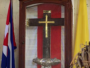
When Christopher Columbus landed in Cuba, he called the place Porto Santo. Many believe this was Baracoa. He also described a nearby flat-topped mountain, which is almost certainly El Yunque. Columbus wrote in his logbook that it was "the most beautiful place in the world". He also said he heard birds singing that would "never ever leave this place". According to tradition, Columbus placed a cross, called Cruz de la Parra, in the sand of what would become Baracoa harbor.
Around August 15, 1511, Diego Velázquez de Cuéllar became the first governor of Cuba. He built a settlement here and named it 'Nuestra Señora de la Asunción de Baracoa'. This made Baracoa the first capital of Cuba. In 1518, it was officially named a city. The first Cuban bishop was also appointed here. Because of its long history, you can still see many old Spanish buildings. These include forts like El Castillo, Matachín, and La Punta.
In the 16th and 17th centuries, Baracoa's isolated location made it a secret trading spot. People would trade illegally with the French and English. Later, in the early 1800s, many people from Saint-Domingue (now Haiti) came to Baracoa. They were escaping the Haitian Revolution. These new settlers started growing coffee and cocoa.
From the mid-1800s, many Cuban independence fighters landed here. Important figures like Antonio Maceo and José Martí arrived in Baracoa. Their efforts greatly helped Cuba gain independence from Spain in 1902.
Before the Cuban Revolution, the only way to reach Baracoa was by sea. But in the 1960s, a 120 km (75 mi) long road called La Farola was built. This road goes through the mountains and was a major project of the revolution. The road's highest point is over 600 meters (2,000 feet) high. It crosses 11 bridges.
Economy and Tourism
The main products grown in the Baracoa region are bananas, coconuts, and cacao. Baracoa is Cuba's main area for making chocolate. Cacao trees are grown under Royal palm trees along rivers like the Río Miel and Río Toa.
Ecotourism and birdwatching are also important in Baracoa. This is because of its beautiful Cuban moist forests.
Visiting Baracoa
Baracoa is located far away on the eastern side of Cuba. This has kept it from becoming too crowded with tourists. You can reach Baracoa by bus from Santiago de Cuba (about four hours). You can also fly from Havana (about two hours).
Many old forts are still standing in Baracoa. To the east, you can find Fuerte Matachín, built in 1802. It now has houses and museums. To the west, Fuerte La Punta, built in 1803, is now a restaurant. There is a small beach next to it. The third fort, El Castillo, is on a steep hill. It has a great view of the town and bays. This fort is now a hotel called Hotel El Castillo.
The Catedral Nuestra Señora de la Asunción is a church in Baracoa. It holds parts of the Cruz de la Parra. This is a cross that Columbus is said to have brought from Spain. Scientists have tested the cross and found it is from around that time. However, it is made from a local type of wood. This means at least part of the story might not be correct.
There are two places to enjoy music near the central Parque Independencia. One is Flan de Queso, which is more for tourists. The other is Casa de la Flana, which is more traditional.
Nearby Baracoa are the Miel and Toa rivers. The Toa River has many waterfalls. The most famous one is 'el Saltadero', which is 17 meters (56 feet) high.
The table mountain called el Yunque is 575 meters (1,886 feet) high. It is about 10 km (6 mi) west of Baracoa. This mountain is a leftover from an old plateau. Because it is so isolated, it has many unique types of ferns and palm trees. If you want to climb it, you must have a guide.
From Baracoa, you can also visit the Parque Nacional Alejandro de Humboldt. This national park is about 20 kilometers (12 miles) north of the city.
Salto Fino is the highest waterfall in the Caribbean. It is located in this municipality. The water falls 305 meters (1,000 feet) from a stream called Arroyo del Infierno. This stream flows into the Toa River, which is the largest river in Cuba. Salto Fino is recorded as the 20th-highest waterfall in the world.
Baracoa's Food
Baracoa has some special local dishes. One is cucurucho. This is a mix of coconut, sugar, and other fruits like orange, guava, and pineapple. It is wrapped in a palm leaf. Another dish is Bacán, which is made from bananas and wrapped in a banana leaf. And of course, there is a lot of chocolate in Baracoa. This is because it is a major cocoa-producing region.
Population and Transport
In 2004, the municipality of Baracoa had a population of 81,794 people. The total area is 977 km2 (377 sq mi). This means there were about 83.7 people per square kilometer.
Transportation in Baracoa
Baracoa is the eastern end of the Carretera Central. This is a highway that goes across the entire island of Cuba. It is 1,435 km (892 mi) long.
Baracoa Airport
Gustavo Rizo Airport (BCA/MUBA) is a small regional airport that serves Baracoa. It mainly handles flights within Cuba. The airport is located west of the bay, near the Hotel Porto Santo. It is about 4 km (2.5 miles) northwest of Baracoa. Flights are not very frequent, but Cubana de Aviación flies here from Santiago de Cuba and Havana.
Famous People from Baracoa
- The Cuban artist Pablo Borges Delgado was born in Baracoa.
- The Cuban composer Eduardo Davidson was born in Baracoa.
See also
 In Spanish: Baracoa para niños
 | Valerie Thomas |
 | Frederick McKinley Jones |
 | George Edward Alcorn Jr. |
 | Thomas Mensah |


