Bastogne facts for kids
Quick facts for kids
Bastogne
|
|
|---|---|
|
City and municipality
|
|
 |
|
|
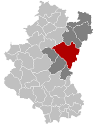
Location of Bastogne
|
|
| Coordinates: 50°0.25′N 05°43.2′E / 50.00417°N 5.7200°E | |
| Country | Belgium |
| Community | French Community |
| Region | Wallonia |
| Province | |
| Arrondissement | Bastogne |
| Government | |
| • Mayor | Benoît Lutgen (cdH) |
| • Governing party/ies | LDB-cdH |
| Population
(2018-01-01)
|
|
|
• Total
|
15,894 |
| Postal codes |
6600
|
| NIS code |
82039
|
| Area codes | 061 |
| Website | www.bastogne.be |
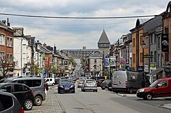
Bastogne is a city and municipality in Wallonia, Belgium. It is located in the province of Luxembourg, within the Ardennes region.
The municipality includes several smaller areas called districts. These are Bastogne, Longvilly, Noville, Villers-la-Bonne-Eau, and Wardin. The city itself sits on a high ridge in the Ardennes mountains, about 510 meters (1,673 feet) above sea level.
On December 2, 2024, Bastogne officially joined with Bertogne to form a new, larger municipality.
Contents
A Glimpse into Bastogne's Past
Early Days and Roman Times
Long ago, when the Romans arrived, the area around Bastogne was home to a tribe called the Treveri. They were a group of Gauls, ancient people who lived in what is now France and Belgium.
The name Bastogne first appeared in records much later, around the year 634. At that time, a local lord gave these lands to a place called St Maximin's Abbey, near a city called Trier. About a hundred years later, the Bastogne area became part of the nearby Prüm Abbey.
Medieval Growth and City Walls
Bastogne and its marketplace were mentioned again in a document from 887. By the 1200s, Henry VII, who was the count of Luxemburg, even made coins in Bastogne.
In 1332, his son, John the Blind, gave Bastogne its official city rights. He also ordered strong defensive walls to be built around the city. A part of these old walls, called the Porte de Trèves, can still be seen today.
These city walls were very good at protecting Bastogne during tough times. The city's economy actually grew because its markets for farm products and cattle became very famous. In 1602, the walls successfully stopped an attack by forces from the Dutch Republic. However, in 1688, King Louis XIV ordered the walls to be taken down when French forces took over the town during the Nine Years War.
Modern Times and World Wars
The 1800s were good for Bastogne, especially after Belgium became an independent country. Its forest products and cattle fairs became even more well-known. Several railway lines were built, connecting Bastogne to nearby towns. This period of growth ended when German forces occupied the area during World War I.
Bastogne and World War II
Bastogne was freed by the Allied forces on September 10, 1944. But just a few months later, German forces attacked again. Adolf Hitler wanted to take back control of the Ardennes region. His plan was to split the British and American armies, then capture the important port of Antwerp to cut off Allied supplies.
The Battle of the Bulge began on December 16, 1944. German artillery, hidden by cold weather and fog, attacked American divisions spread out around Bastogne. A few days later, American soldiers, including Brigadier General Anthony McAuliffe and the 101st Airborne Division, arrived to fight back. After heavy fighting, they became surrounded inside the town.
On December 22, German messengers asked the Americans to surrender. General McAuliffe famously replied with just one word: “Nuts!” The next day, the skies cleared. This allowed Allied planes to attack the German forces and drop much-needed food, medicine, and weapons to the American soldiers.
On December 26, the Third U.S. Army, led by General George S. Patton, arrived and broke through the German lines. The fighting in the Bastogne area officially ended three weeks later.
Bastogne is now the end point of the Liberty Road. This special route marks the path of the Allied forces who freed Europe and the Third Army that helped Bastogne.
Where is Bastogne?
Bastogne is located in the Ardennes region of Belgium. It is in the eastern part of the province of Luxembourg. The city is about 12 kilometers (7.5 miles) from the border with Luxembourg.
Bastogne is quite high up, at about 515 meters (1,690 feet) above sea level. It sits on a ridge that separates the areas where rivers flow towards the Rhine and Meuse rivers. It is the 9th largest municipality in Belgium by area.
The municipality of Bastogne is made up of five main sections. These sections used to be separate towns before they merged in 1977. Each section also includes several smaller villages:
- Bastogne: Bizory, Chifontaine, Hemroulle, Isle-la-Hesse, Isle-le-Pré, Savy, Senonchamps
- Longvilly: Al-Hez, Arloncourt, Bourcy, Horritine, Michamps, Moinet, Oubourcy
- Noville: Cobru, Fagnoux, Foy, Hardigny, Luzery, Rachamps, Recogne, Vaux, Wicourt
- Villers-la-Bonne-Eau: Livarchamps, Losange, Lutrebois, Lutremange, Remoifosse
- Wardin: Benonchamps, Bras, Harzy, Mageret, Marenwez, Marvie, Mont, Neffe
Bastogne's Weather
Bastogne has an oceanic climate, similar to the rest of Belgium. However, because it is inland and higher up, it has slightly more extreme weather than coastal areas. Winters are still mild for its location, but snow and frost are common. Temperatures usually stay just above freezing.
| Climate data for Bastogne (1981–2010 normals; sunshine 1984–2013) | |||||||||||||
|---|---|---|---|---|---|---|---|---|---|---|---|---|---|
| Month | Jan | Feb | Mar | Apr | May | Jun | Jul | Aug | Sep | Oct | Nov | Dec | Year |
| Mean daily maximum °C (°F) | 3.1 (37.6) |
4.2 (39.6) |
8.2 (46.8) |
12.1 (53.8) |
16.3 (61.3) |
19.1 (66.4) |
21.4 (70.5) |
21.1 (70.0) |
17.2 (63.0) |
12.7 (54.9) |
7.0 (44.6) |
3.8 (38.8) |
12.3 (54.1) |
| Daily mean °C (°F) | 0.3 (32.5) |
0.8 (33.4) |
4.1 (39.4) |
7.1 (44.8) |
11.3 (52.3) |
14.1 (57.4) |
16.3 (61.3) |
15.9 (60.6) |
12.5 (54.5) |
8.8 (47.8) |
4.2 (39.6) |
1.3 (34.3) |
8.2 (46.8) |
| Mean daily minimum °C (°F) | −2.4 (27.7) |
−2.7 (27.1) |
0.0 (32.0) |
2.2 (36.0) |
6.3 (43.3) |
9.0 (48.2) |
11.2 (52.2) |
10.7 (51.3) |
7.8 (46.0) |
5.1 (41.2) |
1.4 (34.5) |
−1.2 (29.8) |
4.0 (39.2) |
| Average precipitation mm (inches) | 104.9 (4.13) |
83.2 (3.28) |
86.9 (3.42) |
68.5 (2.70) |
78.5 (3.09) |
79.4 (3.13) |
76.9 (3.03) |
81.9 (3.22) |
78.7 (3.10) |
91.4 (3.60) |
90.0 (3.54) |
105.5 (4.15) |
1,025.8 (40.39) |
| Average precipitation days | 14.4 | 12.3 | 14.4 | 10.8 | 12.1 | 11.7 | 11.9 | 11.1 | 11.1 | 12.8 | 14.5 | 15.2 | 152.1 |
| Mean monthly sunshine hours | 43 | 70 | 117 | 165 | 193 | 194 | 212 | 200 | 140 | 100 | 46 | 34 | 1,513 |
| Source: Royal Meteorological Institute | |||||||||||||
Places to See in Bastogne

- The 101st Airborne Museum shows what it was like for soldiers and civilians during the siege of Bastogne in World War II. It uses detailed displays to tell their stories.
- The Bastogne Barracks museum is run by the Belgian Army and is free to visit. It is located in the actual barracks that the U.S. 101st Airborne used as their headquarters during the Siege of Bastogne. You can see many restored tanks and military vehicles. There's also a guided tour of the underground barracks and items from American, German, and British forces. The museum includes the basement office where General McAuliffe gave his famous "Nuts!" reply.
- The Bastogne War Museum has many items from the war and videos that help visitors understand the experience of the Battle of the Bulge.
- The Porte de Trèves is a part of the old defensive walls built in the 1300s by John the Blind. You can still see it today.
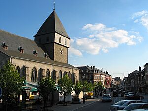
- The Romanesque tower of St Pierre church and its old baptismal fonts also date back to the Middle Ages.
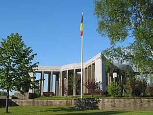
- The Mardasson Memorial was built near Bastogne in 1950. It honors American soldiers who were hurt or died during the Battle of the Bulge.
- You can find monuments to important figures like Brigadier General McAuliffe and General Patton around town.
- The Recogne German war cemetery, about 6 kilometers (3.7 miles) north, is where 6,807 German soldiers are buried.
Local Traditions
The main character in many Bastogne legends is called the piche-cacaye. This name is pronounced "pish-cackay".
Getting Around Bastogne
Bastogne used to have a railway line that connected it to Libramont and Gouvy. Passenger trains to Gouvy stopped in 1984, and the line to Libramont was closed in the 1990s. The two old train station buildings in Bastogne are still there, but they are now used for other things. Part of the old railway line has been turned into a path for bicycles.
The city has two bus stations, Bastogne Nord and Bastogne Sud. These stations help people travel by bus to nearby areas.
Sports in Bastogne
- Bastogne is the halfway point of the Liège–Bastogne–Liège classic bicycle race. This is one of the oldest and most famous one-day professional road cycling events, started in the late 1800s.
- The Circuit des Ardennes used to be a 600-kilometer (373-mile) car race near Bastogne. Famous people, like German Emperor William II, used to attend this race. It was later moved to Francorchamps around World War I, where it is now known as the Belgian Grand Prix. Today, "Circuit des Ardennes" refers to a bicycle race.
See also
 In Spanish: Bastoña para niños
 | Percy Lavon Julian |
 | Katherine Johnson |
 | George Washington Carver |
 | Annie Easley |


