Batoche facts for kids
Quick facts for kids
Batoche
|
|
|---|---|
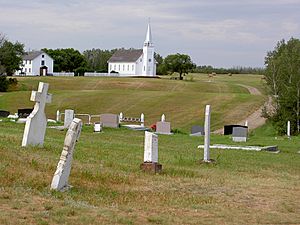
Church, rectory and cemetery of Saint Antoine de Padoue in Batoche
|
|
| Country | Canada |
| Province | Saskatchewan |
| Region | Southcentral Saskatchewan |
| Census division | 15 |
| Rural Municipality | St. Louis No. 431 |
| Established | 1872 |
| Incorporated (village) | 1885 |
| Designation (National Historic Site) | 1923 |
| Time zone | CST |
| Postal code |
S0J 1E0
|
| Area code(s) | 306 |
| Highways | Highway 225 |
| Waterways | South Saskatchewan River |
| Official name: Batoche National Historic Site of Canada | |
| Designated: | 1923 |
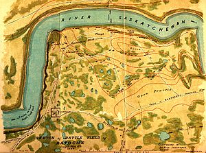
Batoche is a special place in the Canadian province of Saskatchewan, located between the cities of Prince Albert and Saskatoon. It is famous for being the site of the Battle of Batoche in 1885. This battle was a key event during the North-West Rebellion, a conflict involving the Métis and the Canadian government.
During the battle, Louis Riel and his Métis forces were defeated by the Canadian troops led by Major General Frederick Middleton. At that time, Batoche was a small village with about 500 residents. Today, very few people live there. However, the historic church building from 1885 and other old buildings have been saved. Batoche is now a National Historic Site, which means it's a protected area important to Canada's history.
The History of Batoche
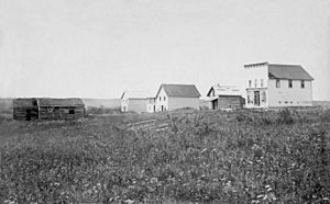
The Métis people created the settlement of Batoche in 1872. It was named after Xavier Letendre, who was also known as Batoche. By 1885, about 500 people lived there. The Métis built their homes along the South Saskatchewan River on special plots of land called "river lots."
The community had several stores and a Roman Catholic church named St. Antoine de Padoue. Batoche became the unofficial capital for Louis Riel's Provisional Government of Saskatchewan during the North-West Rebellion. This government was set up by the Métis to represent their interests.
Batoche is located on the east bank of the South Saskatchewan River, in an area known for its mix of grasslands and small groups of trees, called the aspen parkland. Most of the people living in Batoche were Francophone (French-speaking) and Roman Catholic.
Batoche National Historic Site
Batoche was recognized as a National Historic Site in 1923. This means it's a place that helps tell Canada's story. When you visit, you can go to the visitor centre. There, you'll find a multimedia show that shares the history of Batoche and the people who lived there.
You can also explore several old buildings that have been carefully restored. People dressed in historical costumes work at these sites. They help visitors imagine what life was like for the Métis in Batoche between 1860 and 1900.
The historic sites include an old camp of the North-West Mounted Police (who were like early Canadian police officers). There's also a church and a rectory, which is the home of a priest. You can also see a traditional farm home. These different sites are spread out around the community. The Batoche National Historic Site is usually open from the middle of May until the middle of September.
See also
- List of communities in Saskatchewan
- Bell of Batoche
- Gabriel Dumont
 | Victor J. Glover |
 | Yvonne Cagle |
 | Jeanette Epps |
 | Bernard A. Harris Jr. |


