
Battle Mountain (Virginia) facts for kids
Quick facts for kids Battle Mountain |
|
|---|---|

The western slope of Battle Mountain, Castleton, Virginia
|
|
| Highest point | |
| Elevation | 1,162 ft (354 m) |
| Prominence | 762 ft (232 m) |
| Geography | |

A digital contour plot of Battle Mountain and Little Battle Mountain, based on digital imagery data from the NASA ASTER satellite. Processed by Thomas A. Woolman, PhD (2020), MBA, MS, MS, in 2015.
|
|
| Location | Rappahannock County, Virginia, US |
| Parent range | Blue Ridge Mountains |
| Topo map | USGS Massies Corner, Va. |
| Geology | |
| Age of rock | 704,000,000 years |
| Mountain type | Stratovolcano |
| Volcanic belt | Robertson River Igneous Suite |
| Last eruption | 704 Mya |
Battle Mountain is a special mountain in Rappahannock County, Virginia. It's an igneous mountain, which means it was formed by hot, molten rock. The mountain is split between two small towns: Amissville, Virginia on its eastern side and Castleton, Virginia on its western side. Battle Mountain is 1,162 feet (354.2 meters) tall. The very top of the mountain is on private land.
Contents
How Battle Mountain Formed

A Very Old Volcano
Battle Mountain is an extinct volcano. This means it no longer erupts. It is about 704 million years old. Scientists figured out its age using a special method called geochronology. This method looks at tiny zircon crystals in the rock.
This volcano formed when the Earth's crust was pulling apart. This event helped create the Iapetus Ocean. This ancient ocean was a very early version of the Atlantic Ocean.
What Battle Mountain is Made Of
The mountain is made of a type of rock called granite. This granite is part of the Robertson River Igneous Suite. You can find different kinds of rock here. These include rhyolite on the eastern side. Rhyolite is also found on nearby Little Battle Mountain. Little Battle Mountain is 937 feet tall.
How Battle Mountain Looked Long Ago

Scientists believe Battle Mountain had a huge explosion. This happened about 704 million years ago. The explosion was likely on its eastern side. This idea comes from looking at the rocks. The western side has granite, but the eastern side has rhyolite.
Scientists used computers to guess how the mountain looked. They used special models and data. This helped them create a digital picture. It shows what Battle Mountain might have looked like.
Volcanoes of Rappahannock County

Battle Mountain and Little Battle Mountain are special. They are the only known volcanoes in Rappahannock County. They are also some of the oldest visible extinct volcanoes in Virginia.
You can often find white quartz rocks around the mountain. Quartz is a very hard mineral. It was part of the molten rock that formed the volcano. As the softer rocks wear away, the hard quartz remains.

Visiting Battle Mountain
The closest town is Amissville, Virginia. It is about 4 miles away. Battle Mountain is on private property. This means you need to ask the landowners for permission to visit. This includes going to the top of the mountain.
Farming on the Mountain
The land on Battle Mountain is used for different things. Some areas have trees for timber. Other parts are used for cattle grazing. Farmers also grow crops like corn, hay, and pumpkins.
Battle Mountain Farm is on the eastern side. They grow large pumpkins for Halloween. They use special farming methods. These methods help save water and are good for the environment. They use solar panels to power their farm. This helps them get water from deep wells.
Images for kids
-
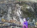
A large rhyolite rock on the eastern side of Battle Mountain. Emily J. Woolman (aged 4) is shown for size.
-
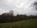
The eastern side of Battle Mountain, seen from about three kilometers away.
-
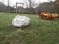
A large white quartz rock near the base of Battle Mountain. Its color shows it came from very hot lava.
-
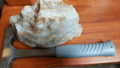
A quartz rock from the eastern side of Battle Mountain. A rock hammer is shown for size. The red color is from iron.
-

The front of a t-shirt from 2019. It was used to promote Battle Mountain Farm's pumpkin sales.
-

The back of a t-shirt from 2019. It was used to promote Battle Mountain Farm's pumpkin sales.


