Begich Peak facts for kids
Quick facts for kids Begich Peak |
|
|---|---|

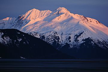
Begich Peak and Boggs Peak (left) seen from Turnagain Arm
|
|
| Highest point | |
| Elevation | 4,623 ft (1,409 m) |
| Prominence | 1,181 ft (360 m) |
| Geography | |
| Location | Chugach National Forest Anchorage Municipality, Alaska United States |
| Parent range | Chugach Mountains |
| Topo map | USGS Seward D-5 |
Begich Peak is a tall mountain in Alaska, standing at about 4,623 feet (1,409 meters) high. It is located in the Chugach Mountains, within the Anchorage Municipality. This peak is part of the beautiful Chugach National Forest.
The mountain is about 2.5 miles (4 km) north of Portage Lake and 5 miles (8 km) northwest of Whittier, Alaska. It is also close to other peaks like Portage Peak and Boggs Peak.
Why is it Called Begich Peak?
Begich Peak was officially named in 1976. It honors Nick Begich (1932-1972), who was a Congressman from Alaska. He was a member of the U.S. House of Representatives.
In 1972, Nick Begich disappeared during an airplane flight from Anchorage to Juneau. He was traveling with Hale Boggs, another important leader in the House of Representatives, and two other people. The plane and the people on board were never found. To remember them, the Begich, Boggs Visitor Center was built near Portage Lake.
Mountain Climate
Begich Peak is in a subarctic climate zone. This means it has very cold, snowy winters and mild summers. Temperatures can drop below −20 °C (which is about −4 °F). With wind, it can feel even colder, sometimes below −30 °C (−22 °F).
The best time to climb Begich Peak is usually in May and June. During these months, the weather is often more favorable. Water from the mountain flows into streams that lead to Portage Creek and the Twentymile River. These rivers eventually empty into Turnagain Arm.
 | Georgia Louise Harris Brown |
 | Julian Abele |
 | Norma Merrick Sklarek |
 | William Sidney Pittman |


