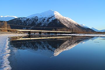
Portage Peak facts for kids
Quick facts for kids Portage Peak |
|
|---|---|

Portage Peak, west aspect
|
|
| Highest point | |
| Elevation | 4,347 ft (1,325 m) |
| Prominence | 1,299 ft (396 m) |
| Isolation | 1.8 mi (2.9 km) |
| Parent peak | Begich Peak |
| Geography | |
| Location | Chugach National Forest Anchorage Municipality, Alaska United States |
| Parent range | Chugach Mountains |
| Topo map | USGS Seward D-6 |
Portage Peak is a cool mountain in Alaska. It stands about 4,347 feet (1,325 meters) tall. This peak is part of the amazing Chugach Mountains.
You can find Portage Peak in the Anchorage area. It's inside the beautiful Chugach National Forest. The mountain is located near the Twentymile River valley. It's also not far from Begich Peak.
Portage Peak sits between the towns of Girdwood and Whittier. The Portage Glacier Highway and the Alaska Railroad run right past its southern base. Water from the mountain flows into Turnagain Arm. This happens through Portage Creek and the Twentymile River. The mountain gets its unofficial name from nearby Portage Creek, Portage Lake, Portage Glacier, and the old Portage town.
Weather and Climate at Portage Peak
Portage Peak has a subarctic climate. This means it has very long, cold, and snowy winters. The summers are usually mild.
The weather here is greatly affected by the Gulf of Alaska. Air from the Gulf moves towards the Chugach Mountains. The mountains force this air to rise. This process is called orographic lift. It causes a lot of rain and snow to fall on the mountain.
Temperatures can get very cold, sometimes dropping below -20 °C (-4 °F). With the wind chill, it can feel even colder, below -30 °C (-22 °F). If you want to visit or climb Portage Peak, the best time is usually from May through June. The weather is most pleasant then.
 | Kyle Baker |
 | Joseph Yoakum |
 | Laura Wheeler Waring |
 | Henry Ossawa Tanner |


