Beinn Sgulaird facts for kids
Quick facts for kids Beinn Sgulaird (Meg's Mountain) |
|
|---|---|

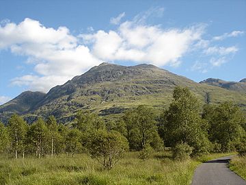
Beinn Sgulaird from the road to Glen Ure House to the west
|
|
| Highest point | |
| Elevation | 937 m (3,074 ft) |
| Prominence | 662 m (2,172 ft) |
| Listing | Munro, Marilyn |
| Naming | |
| Language of name | Gaelic |
| Pronunciation | English approximation: BAYN-skoo-LƏRT-yə |
| Geography | |
| Location | Argyll and Bute, Scotland |
| Parent range | Grampian Mountains |
| OS grid | NN053460 |
| Topo map | OS Landranger 50, OS Explorer 377 |
| Climbing | |
| Easiest route | walk |
Beinn Sgulaird is a tall and impressive Scottish mountain. It stands between two beautiful valleys, Glen Creran and Glen Etive, in the southern Highlands. This mountain reaches a height of 937 meters (about 3,074 feet). Because of its height, it is known as a Munro.
Contents
Discover Beinn Sgulaird
Beinn Sgulaird is a well-known mountain in Scotland. Its name comes from the Gaelic language. It is a popular spot for hillwalkers and adventurers. The mountain offers amazing views of the surrounding Scottish landscape.
Where is Beinn Sgulaird?
Beinn Sgulaird is found in a region called Argyll and Bute in Scotland. It is part of the Grampian Mountains range. You can find it by looking at its grid reference, which is NN053460. This helps people locate it on maps like the OS Landranger 50.
What is a Munro?
In Scotland, a "Munro" is a mountain that is over 3,000 feet (914.4 meters) tall. Beinn Sgulaird is 937 meters high, so it easily qualifies! Climbing all the Munros is a popular challenge for many hikers. This challenge is often called "Munro Bagging."
Exploring the Mountain
Beinn Sgulaird has a unique shape. It is a long ridge that stretches from the southwest to the northeast. About three kilometers of this ridge are above 800 meters in height. This makes for a long and exciting walk along the top.
The Ridge Walk
Many hillwalkers like to walk along the ridge from north to south. This direction gives the best views. You can see far out to the west, towards the Hebrides islands. The Isle of Mull is especially clear on a good day. Imagine seeing distant islands from the top of a mountain!
Starting Your Adventure
Most people begin their climb from Glen Creran, which is to the west of the mountain. However, you can also start your journey from Glen Etive. Both routes offer different challenges and beautiful scenery. Climbing Beinn Sgulaird is a rewarding experience for anyone who loves the outdoors.
 | Delilah Pierce |
 | Gordon Parks |
 | Augusta Savage |
 | Charles Ethan Porter |

