Beinn an Fhogharaidh facts for kids
Quick facts for kids Beinn an Fhogharaidh |
|
|---|---|

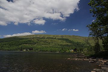
Beinn an Fhogharaidh rising above the north shore of Loch Ard
|
|
| Highest point | |
| Elevation | 616 m (2,021 ft) |
| Prominence | 21 m (69 ft) |
| Isolation | 1.6 km (0.99 mi) |
| Parent peak | Ben Venue |
| Listing | subGraham Top, subSimm |
| Naming | |
| Language of name | Scottish Gaelic |
| Geography | |
| Location | Trossachs, Scottish Highlands, UK |
| Parent range | Grampians |
| OS grid | NN475038 |
| Topo map | OS Landranger 57 |
| Climbing | |
| Easiest route | track from Ledard Farm |
Beinn an Fhogharaidh is a mountain ridge in the southern Scottish Highlands. It stands about 616 meters (2,021 feet) tall. This mountain is located near the village of Aberfoyle in the Stirling council area, Scotland.
Where is Beinn an Fhogharaidh?
Beinn an Fhogharaidh is about 6 kilometers (3.7 miles) west-northwest of Aberfoyle. It is also about 16 kilometers (10 miles) south-southwest of Callandar. The mountain is located within the Loch Lomond and The Trossachs National Park. This park is a beautiful area in Scotland.
The highest point of Beinn an Fhogharaidh is about one mile south of Ben Venue. It sits between Creag Innich (522 meters or 1,713 feet) to the east. It is also near Stob an Lochain (684 meters or 2,244 feet) to the northwest. Stob an Lochain is a smaller peak connected to Ben Venue.
What does Beinn an Fhogharaidh look like?
This mountain forms a long ridge without trees on top. It branches off from the southern part of the Ben Venue ridge, which is 727 meters (2,385 feet) high. Beinn an Fhogharaidh runs from northwest to southeast. It rises above the northern shores of Loch Ard in the Trossachs region. This area is part of the Grampians, which are in the southern Scottish Highlands.
Beinn an Fhogharaidh has two main peaks, which is called a double summit. The eastern peak is the highest, but only by one meter. The western peak is about 500 meters away. A shallow dip, called a col, separates the two peaks. This col is about ten meters lower than the peaks.
The lower parts of the mountain are covered in trees. These forests are part of the Queen Elizabeth Forest Park.
How can you climb Beinn an Fhogharaidh?
There is a path that leads to Ledard Farm. This path starts from the B 829 road, which runs along the north shore of Loch Ard. The path climbs up the southeast side of Beinn an Fhogharaidh. It goes below the peak of Creag Innich.
About halfway up the ridge, the path splits. The right-hand path goes in a loop. It runs just below the top of the main ridge. This path goes just below the highest point and crosses the western peak. It then continues towards the rocky cliffs of Stob an Lochain.
 | Georgia Louise Harris Brown |
 | Julian Abele |
 | Norma Merrick Sklarek |
 | William Sidney Pittman |

