Bellefontaine Neighbors, Missouri facts for kids
Quick facts for kids
Bellefontaine Neighbors, Missouri (bel-Fawn-tāine)
|
|
|---|---|

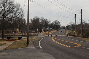
Bellefontaine Road in Bellefontaine Neighbors, Missouri, February 2017
|
|

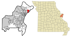
Location of Bellefontaine Neighbors, Missouri
|
|
| Country | |
| State | |
| County | St. Louis |
| Incorporated | June 19, 1950 |
| Area | |
| • Total | 4.40 sq mi (11.40 km2) |
| • Land | 4.40 sq mi (11.40 km2) |
| • Water | 0.00 sq mi (0.00 km2) |
| Elevation | 492 ft (150 m) |
| Population
(2020)
|
|
| • Total | 10,740 |
| • Density | 2,440.91/sq mi (942.37/km2) |
| Time zone | UTC-6 (Central (CST)) |
| • Summer (DST) | UTC-5 (CDT) |
| FIPS code | 29-04222 |
| GNIS feature ID | 2394117 |
| Website | http://www.cityofbn.com |
Bellefontaine Neighbors (pronounced bel-FOWN-tən) is a city located in St. Louis County, Missouri, in the United States. It's a suburban area, meaning it's a community near a larger city. In 2020, about 10,740 people lived there.
Contents
History
The story of Bellefontaine Neighbors began in the mid-1800s. At that time, this area was part of a huge piece of land called the Louisiana Territory. This land was first given by France to Spain in 1762.
Spanish leaders built forts near the Missouri River to protect their land. One of these forts was near what is now Spanish Lake.
In 1800, Spain gave the territory back to France. Then, in 1803, France sold it to the United States as part of the famous Louisiana Purchase.
Fort Bellefontaine
In 1804, a special agreement was made with the Sac and Fox Indians. This led to the creation of a trading post on the south side of the Missouri River. This spot was chosen because it had a large, clear water spring. Early French settlers called this spring "la belle fontaine," which means "the beautiful fountain."
By 1805, a military base called Fort Bellefontaine was built. It had log cabins, a trading house, a bakery, and a blacksmith shop. General Daniel Bissell was an important military leader who lived at the fort for many years. A path connected the fort to St. Louis, which later became Bellefontaine Road. The fort was closed in 1834.
From Farmland to City
After the fort closed, the land was divided up. For a long time, the area was mostly farmland. But after World War II, in the 1950s, many new homes were built. This caused the population to grow a lot.
Bellefontaine Neighbors officially became a city on June 19, 1950. At that time, only 766 people lived there. The city had 18 streets, one public school, and one church.
Between 1950 and 1960, the city grew very quickly. The population jumped to 13,650 people by 1960! More churches and schools were built to serve the growing community.
The city is run by a mayor and aldermen, who are elected by the people. They help make decisions for the community.
Geography
Bellefontaine Neighbors is a suburb located just north of St. Louis. It covers an area of about 4.32 square miles (11.40 square kilometers), and all of it is land.
Demographics
The population of Bellefontaine Neighbors has changed over the years. Here's how many people lived there during different census counts:
| Historical population | |||
|---|---|---|---|
| Census | Pop. | %± | |
| 1960 | 13,650 | — | |
| 1970 | 14,084 | 3.2% | |
| 1980 | 12,082 | −14.2% | |
| 1990 | 10,922 | −9.6% | |
| 2000 | 11,271 | 3.2% | |
| 2010 | 10,860 | −3.6% | |
| 2020 | 10,740 | −1.1% | |
| U.S. Decennial Census | |||
The city's population reached its highest point in 1970 with over 14,000 people. Since then, the number of residents has slowly decreased.
Population Makeup
The city is home to people from many different backgrounds. The U.S. Census collects information on race and ethnicity.
| Race / Ethnicity (NH = Non-Hispanic) | Pop 2000 | Pop 2010 | Pop 2020 | % 2000 | % 2010 | % 2020 |
|---|---|---|---|---|---|---|
| White alone (NH) | 6,034 | 2,770 | 1,396 | 53.54% | 25.51% | 13.00% |
| Black or African American alone (NH) | 4,986 | 7,874 | 8,886 | 44.24% | 72.50% | 82.74% |
| Native American or Alaska Native alone (NH) | 21 | 12 | 27 | 0.19% | 0.11% | 0.25% |
| Asian alone (NH) | 29 | 18 | 18 | 0.26% | 0.17% | 0.17% |
| Pacific Islander alone (NH) | 2 | 1 | 1 | 0.02% | 0.01% | 0.01% |
| Other race alone (NH) | 9 | 17 | 48 | 0.08% | 0.16% | 0.45% |
| Mixed race or Multiracial (NH) | 114 | 114 | 230 | 1.01% | 1.05% | 2.14% |
| Hispanic or Latino (any race) | 76 | 54 | 134 | 0.67% | 0.50% | 1.25% |
| Total | 11,271 | 10,860 | 10,740 | 100.00% | 100.00% | 100.00% |
In 2020, about 21.5% of the people in Bellefontaine Neighbors were under 18 years old. The average age in the city was 43.2 years.
Places of Interest
Bellefontaine Neighbors has some interesting historical places:
- General Daniel Bissell House: This historic house was added to the National Register of Historic Places in 1978.
- Wilson Larimore House: This is another historic house and former plantation. It was added to the National Register of Historic Places in 1989.
Notable People
Some well-known people who have lived in Bellefontaine Neighbors include:
- Tommie Pierson Jr., a state representative
- Gina Walsh, a state senator
See also
 In Spanish: Bellefontaine Neighbors para niños
 | Kyle Baker |
 | Joseph Yoakum |
 | Laura Wheeler Waring |
 | Henry Ossawa Tanner |

