Bethlehem, Indiana facts for kids
Quick facts for kids
Bethlehem
|
|
|---|---|

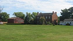
The Abbott-Holloway Farm
|
|

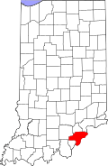
Clark County's location in Indiana
|
|
| Country | United States |
| State | Indiana |
| County | Clark |
| Township | Bethlehem |
| Elevation | 472 ft (144 m) |
| ZIP code |
47162
|
| FIPS code | 18-05104 |
| GNIS feature ID | 430971 |
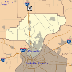
Bethlehem is a small community in Bethlehem Township, Clark County, Indiana, United States. It sits along the Ohio River, about 25 miles from Louisville, Kentucky. This town was planned out in 1812. It was likely named after Bethlehem, Pennsylvania. The first post office opened here in 1816. Many people love to send their Christmas cards from Bethlehem. They want the special Bethlehem postmark on their holiday mail!
Contents
History of Bethlehem
Much of Bethlehem's early history was lost. This happened because of the big Ohio River flood of 1937. We do know that Colonel John Armstrong owned the land first. He was a commander at Fort Finney. This fort was in what is now Jeffersonville, Indiana.
Early Settlement and Growth
The first settlers arrived in 1805. Colonel Armstrong and others, like Jonathon Clark, planned the town in 1812. They laid out 124 lots in a neat rectangle. Armstrong named the town Bethlehem after his birthplace in Pennsylvania.
Bethlehem was an important transportation hub early on. It had a landing for steamboats and a ferry crossing. Roads connected it to nearby towns like New Washington and Lexington, Indiana. The town's economy focused on farming, shopping, and trade. By 1833, about 300 people lived there.
Many old buildings in Bethlehem have been destroyed. Fires and tornadoes caused a lot of damage. Only three buildings from before 1840 are still standing. One of these is the main house of the Abbott-Holloway Farm.
Later Years and Community Spirit
In 1861, a large crowd gathered in Bethlehem. They waved goodbye to their men leaving for war. This made farming harder for a while. There was a worry in 1863 that Morgan's Raid might come through. But the raid never reached the area.
The town's population decreased between 1880 and 1900. Bethlehem no longer had ferry service then. However, it was still big enough to have a Grand Army of the Republic post. After 1900, Bethlehem also had a Red Men tribe and a Degree of Pocahontas council. These were social groups.
In 1993, a group called Historic Bethlehem Inc. was started. They turned the old elementary school into a community center. Today, children from Bethlehem go to school in New Washington. This group also started the yearly Autumn on the River festival. The Abbott-Holloway Farm was added to the National Register of Historic Places in 1994.
Christmas Mail Tradition
Because of its name, Bethlehem is a very popular place to mail Christmas cards. Since 1947, a special stamp is available. It shows "a red picture of the Three Wise Men following the star to Bethlehem." In December, between 5,000 and 7,000 letters might be mailed. During the rest of the year, 100 letters is a busy day! Most people who mail from Bethlehem come from outside Clark County.
Geography
Bethlehem is located right next to the Ohio River. It is near the border with Jefferson County, Indiana. Across the Ohio River is Oldham County, Kentucky. The farmland in Bethlehem is higher than the river's flood plain. This meant that shipping goods by the Ohio River was very important in the past.
 | Aaron Henry |
 | T. R. M. Howard |
 | Jesse Jackson |


