
Big Coppitt Key facts for kids

Big Coppitt Key, as seen northbound on U.S. 1
|
|

Big Coppitt Key
Location in Florida

Big Coppitt Key
Location in Caribbean
|
|
| Geography | |
|---|---|
| Location | Gulf of Mexico |
| Coordinates | 24°35′52″N 81°39′24″W / 24.59778°N 81.65667°W |
| Archipelago | Florida Keys |
| Adjacent bodies of water | Florida Straits |
| Administration | |
| State | Florida |
| County | Monroe |
Big Coppitt Key is a lovely island located in the lower Florida Keys in Florida, United States. It's part of Monroe County. The island's name might come from an old English word, "coppice," which means a thick group of small trees or bushes. Long ago, in 1855, a place called Happy Jack's plantation was located here.
Contents
Exploring Big Coppitt Key
Big Coppitt Key is found at these coordinates: 24°35′52″N, 81°39′24″W. It's a key part of the famous Overseas Highway (U.S. 1). This highway crosses the island between mile markers 9.5 and 11. You'll find it between East Rockland Key and the Saddlebunch Keys.
Life on the Island
Big Coppitt Key is home to many local businesses. It also has a fire and rescue station run by Monroe County. The Monroe County Sheriff's Office helps keep everyone safe. There are three churches on the island too.
The island has three parks where you can have fun. One park even has a playground, and another has a basketball court. These parks are located in the "avenues" part of the island. There's also a cemetery at Avenue A and 4th Street.
Facing the Storms
Islands like Big Coppitt Key sometimes face strong storms called hurricanes. In 2005, Hurricane Wilma caused a lot of damage. Many buildings were flooded or destroyed.
Later, in 2017, Hurricane Irma also brought severe wind and water damage. Most homes were badly affected. However, one famous spot, Bobalu's Southern Cafe, was lucky. They prepared well by boarding up windows and moving outdoor items. This helped save the popular restaurant from major damage.
Big Coppitt Key Community
|
Big Coppitt Key, Florida
|
|
|---|---|

Location in Monroe County and the state of Florida
|
|

U.S. Census Bureau map showing CDP boundaries
|
|
| Country | United States |
| State | Florida |
| County | Monroe |
| Area | |
| • Total | 1.84 sq mi (4.77 km2) |
| • Land | 1.15 sq mi (2.99 km2) |
| • Water | 0.69 sq mi (1.78 km2) |
| Elevation | 3 ft (1 m) |
| Population
(2020)
|
|
| • Total | 2,869 |
| • Density | 2,486.14/sq mi (960.06/km2) |
| Time zone | UTC-5 (Eastern (EST)) |
| • Summer (DST) | UTC-4 (EDT) |
| ZIP Code |
33040 (Key West)
|
Big Coppitt Key is also the name of a special community. It's called a census-designated place, or CDP. This community includes Big Coppitt Key island itself, plus the nearby islands of Geiger Key and Shark Key. In 2020, about 2,869 people lived here.
The United States Census Bureau helps us understand how many people live in different areas. They reported that this community covers about 1.84 square miles (4.77 square kilometers). Most of this area, about 1.15 square miles (2.99 square kilometers), is land. The rest, about 0.69 square miles (1.78 square kilometers), is water.
Population Changes Over Time
The number of people living in Big Coppitt Key has changed over the years. Here's how the population has grown:
| Historical population | |||
|---|---|---|---|
| Census | Pop. | %± | |
| 1980 | 1,856 | — | |
| 1990 | 2,388 | 28.7% | |
| 2000 | 2,595 | 8.7% | |
| 2010 | 2,458 | −5.3% | |
| 2020 | 2,869 | 16.7% | |
| source: | |||
In 2020, the census counted 2,869 people living in the Big Coppitt Key community. There were 1,082 households and 617 families.
Images for kids
-
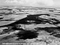
Aerial view, 1940
-
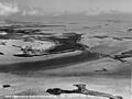
Aerial view, 1940
-
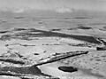
Aerial view, 1940
.jpg)
.jpg)
.jpg)
