Big Piney River facts for kids
Quick facts for kids Big Piney River |
|
|---|---|

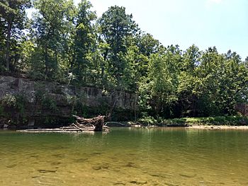
The Big Piney River near Houston, Missouri.
|
|
| Country | United States |
| State | Missouri |
| Region | Ozark Plateau |
| Cities | Cabool, Houston, Fort Leonard Wood |
| Physical characteristics | |
| Main source | Dunn just west of Cabool, Missouri 1,500 ft (460 m) 37°08′47″N 92°11′18″W / 37.14639°N 92.18833°W |
| River mouth | Gasconade River North of Devils Elbow, Missouri, Pulaski County, North-Central Ozark Plateau, Missouri 689 ft (210 m) 37°53′01″N 92°03′51″W / 37.88361°N 92.06417°W |
| Basin features | |
| Tributaries |
|
The Big Piney River is a river in south central Missouri, United States. It is about 110-mile-long (180 km). This river flows into the Gasconade River. From there, its waters join the Missouri and then the Mississippi River. This means it is part of the huge Mississippi River basin.
The river got its name because of the many thick pine trees that grew along its banks.
Contents
Where the Big Piney River Starts and Flows
The Big Piney River begins in the southwest part of Texas County. Its starting point is just north of a small community called Dunn. It is also near U. S. Route 60.
Journey Through Missouri
The river first flows towards the east and then the southeast. It passes just south of Cabool. Along this path, it goes under several roads. These include Route 60 Business, Missouri Route 181, and U. S. Route 63.
The river then turns to flow northeast. It runs next to Route 63 and passes under it three times. After this, it turns northwest, north of Simmons.
Heading North
The Big Piney River then winds its way north. It goes under Missouri Route 17. This is west of Houston and east of Bucyrus. The river keeps flowing north. It passes under Missouri Route 32 and goes by Hazleton. Along this part of its journey, you can find the Paddy Creek Recreation Area and the Slabtown Spring area.
Reaching the Gasconade River
The river then enters the southeastern part of Pulaski County. It continues north past Ross Bridge. It also flows through an eastern section of the Fort Leonard Wood military base.
North of Fort Leonard Wood, the river turns sharply east. For a short time, it goes through a part of Phelps County. This is north of Spring Creek. It then turns back west. It flows past Moab and Devils Elbow. Finally, it passes under Interstate 44 and goes by Hooker. Here, it meets the Gasconade River, where its journey ends.
See also
 In Spanish: Río Big Piney para niños
 | George Robert Carruthers |
 | Patricia Bath |
 | Jan Ernst Matzeliger |
 | Alexander Miles |

