Big Run (Little Muncy Creek tributary) facts for kids
Quick facts for kids Big Run |
|
|---|---|

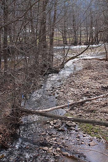
Big Run looking downstream in its lower reaches
|
|
| Physical characteristics | |
| Main source | valley in Penn Township, Lycoming County, Pennsylvania 1,170 ft (360 m) |
| River mouth | Little Muncy Creek in Franklin Township, Lycoming County, Pennsylvania near Lairdsville 735 ft (224 m) 41°13′55″N 76°36′33″W / 41.23185°N 76.60919°W |
| Length | 4.3 mi (6.9 km) |
| Basin features | |
| Progression | Little Muncy Creek → Muncy Creek → West Branch Susquehanna River → Susquehanna River → Chesapeake Bay |
| Basin size | 3.99 sq mi (10.3 km2) |
| Tributaries |
|
Big Run is a small stream, or tributary, located in Lycoming County, Pennsylvania. It flows into a larger stream called Little Muncy Creek. Big Run is about 4.3 miles (7 kilometers) long. It travels through two areas: Penn Township and Franklin Township. The land area that drains into Big Run, called its watershed, is about 3.99 square miles (10.3 square kilometers).
Contents
Where Big Run Flows
Big Run starts in a valley in Penn Township. It flows generally southwest, then west, and then south-southwest. As it flows, it collects water from several smaller, unnamed streams.
The stream then enters Franklin Township. Its valley gets wider before it crosses Pennsylvania Route 118. Finally, Big Run meets and joins Little Muncy Creek. This meeting point is about 14.22 miles (22.89 kilometers) upstream from where Little Muncy Creek ends.
Water Quality of Big Run
Big Run's water quality is currently not as good as it could be. It has higher levels of a substance called nitrogen. Nitrogen is a nutrient, but too much of it can harm water ecosystems.
Because of this, Big Run is considered a priority stream. Both the United States Department of Agriculture and the United States Environmental Protection Agency are working to improve its water quality. They focus on reducing nitrogen from farming activities.
Land and Landscape Around Big Run
The land around Big Run changes as the stream flows. The lowest point of Big Run, where it joins Little Muncy Creek, is about 735 feet (224 meters) above sea level. Where Big Run begins, its source is higher, at about 1170 feet (357 meters) above sea level.
The valley floor along Big Run is mostly made of alluvium. This is a type of soil with sand and gravel that rivers deposit. The sides of the valley are made of harder bedrock, which includes sandstone and shale.
Long ago, during the Wisconsinan Glaciation (a time when glaciers covered much of the Earth), ice reached Big Run's valley. The ice was very thick, even near its edge.
Big Run's Watershed Area
The watershed of Big Run covers an area of 3.99 square miles (10.3 square kilometers). A watershed is all the land where water drains into a particular stream or river.
The mouth of Big Run is located near Lairdsville, Pennsylvania. The stream's source is in a different area called Sonestown. Big Run also flows through the Picture Rocks area.
History of Big Run
Big Run was officially recognized and added to the Geographic Names Information System on August 2, 1979. This system keeps track of names and locations of places in the United States.
Over the years, several bridges have been built across Big Run:
- In 1929, a concrete bridge was built about 1 mile (1.6 kilometers) north of Lairdsville. It carries State Route 2015 and is 32.2 feet (9.8 meters) long.
- In 1937, another concrete bridge was built in Lairdsville. This bridge carries a local township road and Pennsylvania Route 118. It is 33.1 feet (10.1 meters) long.
In 2011, a company called Chief Gathering LLC. had to pay a fine. This was because they accidentally released about 25,200 gallons (95,400 liters) of water into Big Run's watershed. This happened during a test of a pipeline they were building. The Pennsylvania Department of Environmental Protection issued the fine to make sure companies protect the environment.
 | Claudette Colvin |
 | Myrlie Evers-Williams |
 | Alberta Odell Jones |

