Black Cap Mountain (Alaska) facts for kids
Quick facts for kids Black Cap Mountain |
|
|---|---|

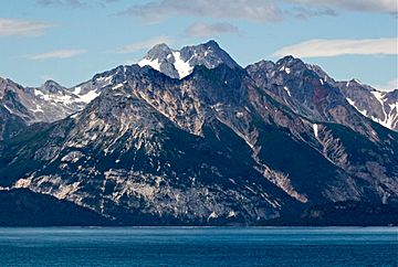
Black Cap Mountain directly in front of Mount Merrian, the highest peak
|
|
| Highest point | |
| Elevation | 3,321 ft (1,012 m) |
| Prominence | 285 ft (87 m) |
| Isolation | 1.13 mi (1.82 km) |
| Parent peak | Mount Merriam (5,083 ft) |
| Geography | |
| Location | Glacier Bay National Park Hoonah-Angoon Alaska, United States |
| Parent range | Takhinsha Mountains Alsek Ranges Saint Elias Mountains |
| Topo map | USGS Mount Fairweather D-2 |
| Geology | |
| Age of rock | Silurian |
| Type of rock | limestone |
| Climbing | |
| Easiest route | Scrambling South ridge |
Black Cap Mountain is a mountain in southeast Alaska that stands about 3,321 feet (1,012 meters) tall. It's located inside Glacier Bay National Park and Preserve. This mountain is part of the Alsek Ranges within the larger Saint Elias Mountains.
Black Cap Mountain is found just north of the entrance to Tidal Inlet. It's about 80 miles (129 km) northwest of Juneau. Even though it's not the tallest mountain, it looks very impressive. This is because it rises straight up from the ocean in less than two miles!
The U.S. Geological Survey gave the mountain its name in 1956. The very top of the mountain is made of dark, black rock called limestone. This dark top stands out against the lighter colors of the mountain's sides. It makes the mountain look like it's wearing a "black cap"! The name was officially approved in 1960.
If the weather is clear, you can see Black Cap Mountain from Glacier Bay. Glacier Bay is a very popular spot for cruise ships to visit. The best time to visit or try climbing the peak is usually from May to June, when the weather is nicer.
Mountain Climate and Weather
Black Cap Mountain has a subarctic climate. This means it has very cold, snowy winters and cool summers. The weather here is strongly affected by the nearby Gulf of Alaska.
Weather systems coming from the Gulf of Alaska hit the tall Saint Elias Mountains. This forces the air upwards, causing lots of rain and snow to fall on the mountain. This process is called orographic lift. Temperatures can drop below −4 °F (−20 °C). With the wind chill, it can feel even colder, sometimes below −22 °F (−30 °C). All the rain and melted snow from the mountain flows into the Glacier Bay Basin.


