Black Edge facts for kids
Quick facts for kids Black Edge |
|
|---|---|

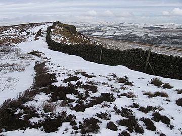
Black Edge on Combs Moss
|
|
| Highest point | |
| Elevation | 507 m (1,663 ft) |
| Prominence | 99 m |
| Parent peak | Shining Tor |
| Listing | Dewey, SubHuMP |
| Geography | |
| Location | Derbyshire, England |
| Parent range | Peak District |
| OS grid | SK062770 |
| Topo map | OS Landranger 119; OL24W |
Black Edge is a hill in England. It is 507 meters (about 1,663 feet) high. This hill is located on a sharp ridge. It sits above the village of Dove Holes. Black Edge is part of the Dark Peak area. This area is found within the beautiful Peak District National Park. It is in the county of Derbyshire.
Exploring Black Edge
Where is Black Edge Located?
The very top of Black Edge is called the summit. A special marker, known as a trig point, shows its exact spot. This trig point is about 1.8 kilometers (1.1 miles) southwest of Dove Holes. It is also about 3.5 kilometers (2.2 miles) north of the old spa town of Buxton.
Black Edge is found in open moorland. It sits on a high ridge made of gritstone. This ridge is like a long, steep slope called an escarpment. It runs mostly from north to south. There are other spots nearby that are almost as high as the main summit.
What is Around Black Edge?
About 900 meters (0.56 miles) north of Black Edge is another spot called Hob Tor. It is also on the same ridge. From Hob Tor, the ridge turns towards the northwest. A smaller path, or spur, goes northeast. On this spur, there is an old burial mound called Lady Low.
To the west of Black Edge, the land slopes down slowly at first. This area is covered in heather and is called Combs Moss. After about a kilometer, the land drops steeply. It goes down into the valley south of Combs Reservoir.
To the east of Black Edge, the steep slope goes down into lower lands. These lowlands are north of Buxton. A railway line runs along the bottom of this steep slope. Next to the railway, you can find the A6 road.
 | Dorothy Vaughan |
 | Charles Henry Turner |
 | Hildrus Poindexter |
 | Henry Cecil McBay |

