
Blue Creek Valley facts for kids
Quick facts for kids Blue Creek Valley |
|
|---|---|

Blue Creek Valley
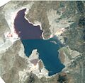
Location in Utah
|
|
| Length | 18 mi (29 km) N-S |
| Width | 8 mi (13 km) |
| Geography | |
| Country | United States |
| State | Utah |
| Region | Great Basin Desert |
| County | Box Elder |
| Communities | Blue Creek and Howell |
| Borders on |
List
|
| River | Blue Creek Spring |
| Lake | Blue Creek Reservoir |
Blue Creek Valley is a long valley in Box Elder County, Utah. It stretches about 18 miles (29 km) long. This valley is special because it is an endorheic basin. This means that any water that flows into the valley stays there and does not flow out to a river or ocean. The lowest point in the valley is the Blue Creek Reservoir.
The valley is surrounded by mountains. To the east and southeast are the West Hills and Blue Spring Hills. The Promontory Mountains are to the south. A smaller mountain range called the North Promontory Mountains forms the western side. To the north, Blue Creek Valley meets the Pocatello Valley in Idaho.
What is Blue Creek Valley Like?
Blue Creek Valley is quite narrow, only about 5 to 8 miles (8 to 13 km) wide. Because it's narrow, many small creeks flow into it from all directions. The most important water source is the Blue Creek Spring, which is about 2 miles (3 km) northeast of the Blue Creek Reservoir. This spring is the main feeder for the reservoir.
The water from Blue Creek Reservoir flows south, past the town of Howell, Utah. This area is mostly farmland. The southern end of the valley is marked by the foothills of the Promontory Mountains. A mountain called Engineer Mountain, which is about 5,400 feet (1,646 meters) tall, is part of this area. Water from the northern parts of the Promontory Mountains drains into the southern part of Blue Creek Valley. However, some water from the southwest side of these mountains flows towards the Bear River Bay, which is part of the Great Salt Lake.
Lowest Point in the Valley
The lowest part of Blue Creek Valley is located south of the Blue Creek Reservoir, near the farmlands around Howell, Utah. The Blue Creek Reservoir itself sits at an elevation of about 4,593 feet (1,400 meters) above sea level.
Images for kids
-
Blue Creek Valley, north-northeast of the peninsular-Promontory Mountains, only extreme south visible against the hills/mountains
(the ridgeline terminus of the North Promontory Mountains to west, the circular mountain between the two, is Cedar Ridge)
(the brownish hills SE-(at Penrose, Utah), are the Blue Spring Hills)

