Howell, Utah facts for kids
Quick facts for kids
Howell
|
|
|---|---|

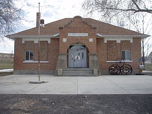
The old schoolhouse in Howell, March 2009
|
|

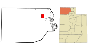
Location of Howell within Box Elder County and the State of Utah.
|
|

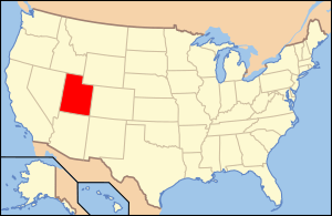
Location of Utah in the United States
|
|
| Country | United States |
| State | Utah |
| County | Box Elder |
| Settled | 1910 |
| Incorporated | 1941 |
| Named for | Joseph Howell |
| Area | |
| • Total | 35.47 sq mi (91.87 km2) |
| • Land | 35.27 sq mi (91.36 km2) |
| • Water | 0.20 sq mi (0.51 km2) |
| Elevation | 4,561 ft (1,390 m) |
| Population
(2010)
|
|
| • Total | 245 |
| • Estimate
(2019)
|
254 |
| • Density | 7.20/sq mi (2.78/km2) |
| Time zone | UTC-7 (Mountain (MST)) |
| • Summer (DST) | UTC-6 (MDT) |
| ZIP code |
84316
|
| Area code(s) | 435 |
| FIPS code | 49-36620 |
| GNIS feature ID | 2412774 |
Howell is a small town in Utah, United States. It is located in the Blue Creek Valley in the northeast part of Box Elder County. In 2010, about 245 people lived there. Howell was settled in 1910 and became an official town in 1941. It was named after Joseph Howell, a person involved in the land company that helped develop the area.
Contents
Howell's Location and Land
Howell is a town in Utah. It covers about 35.6 square miles (91.87 square kilometers). Most of this area is land, with a small part being water.
Howell's Climate and Weather
The weather in Howell is a mix of semi-arid (dry) and humid continental climate (with all four seasons). This means it has cold winters and warm to hot summers. There are also big changes between daytime and nighttime temperatures.
A weather station nearby at Thiokol Airport helps us know more about the climate.
| Climate data for Thiokol Propulsion F S, Utah, 1991–2020 normals, 1962-2020 extremes: 4600ft (1402m) | |||||||||||||
|---|---|---|---|---|---|---|---|---|---|---|---|---|---|
| Month | Jan | Feb | Mar | Apr | May | Jun | Jul | Aug | Sep | Oct | Nov | Dec | Year |
| Record high °F (°C) | 56 (13) |
65 (18) |
74 (23) |
85 (29) |
96 (36) |
103 (39) |
108 (42) |
107 (42) |
98 (37) |
88 (31) |
78 (26) |
60 (16) |
108 (42) |
| Mean maximum °F (°C) | 44.6 (7.0) |
53.5 (11.9) |
67.0 (19.4) |
77.5 (25.3) |
85.5 (29.7) |
95.4 (35.2) |
100.9 (38.3) |
99.6 (37.6) |
93.4 (34.1) |
81.1 (27.3) |
61.5 (16.4) |
48.2 (9.0) |
101.9 (38.8) |
| Mean daily maximum °F (°C) | 29.8 (−1.2) |
36.7 (2.6) |
48.4 (9.1) |
56.0 (13.3) |
66.8 (19.3) |
81.1 (27.3) |
89.6 (32.0) |
89.1 (31.7) |
77.0 (25.0) |
60.4 (15.8) |
44.4 (6.9) |
34.3 (1.3) |
59.5 (15.3) |
| Daily mean °F (°C) | 21.2 (−6.0) |
24.9 (−3.9) |
36.1 (2.3) |
43.1 (6.2) |
53.1 (11.7) |
64.1 (17.8) |
71.9 (22.2) |
70.8 (21.6) |
59.5 (15.3) |
44.7 (7.1) |
32.8 (0.4) |
23.1 (−4.9) |
45.4 (7.5) |
| Mean daily minimum °F (°C) | 12.5 (−10.8) |
13.2 (−10.4) |
23.7 (−4.6) |
30.1 (−1.1) |
39.3 (4.1) |
47.0 (8.3) |
54.2 (12.3) |
52.4 (11.3) |
42.0 (5.6) |
28.9 (−1.7) |
21.2 (−6.0) |
12.0 (−11.1) |
31.4 (−0.3) |
| Mean minimum °F (°C) | −1.7 (−18.7) |
−0.5 (−18.1) |
11.0 (−11.7) |
20.3 (−6.5) |
26.9 (−2.8) |
35.3 (1.8) |
45.2 (7.3) |
42.6 (5.9) |
30.1 (−1.1) |
18.0 (−7.8) |
6.3 (−14.3) |
−2.8 (−19.3) |
−8.1 (−22.3) |
| Record low °F (°C) | −28 (−33) |
−29 (−34) |
−5 (−21) |
10 (−12) |
15 (−9) |
29 (−2) |
35 (2) |
30 (−1) |
20 (−7) |
10 (−12) |
−17 (−27) |
−27 (−33) |
−29 (−34) |
| Average precipitation inches (mm) | 1.42 (36) |
0.98 (25) |
1.24 (31) |
1.12 (28) |
1.84 (47) |
1.09 (28) |
0.60 (15) |
0.82 (21) |
0.98 (25) |
1.13 (29) |
0.72 (18) |
1.47 (37) |
13.41 (340) |
| Average snowfall inches (cm) | 5.2 (13) |
4.5 (11) |
0.7 (1.8) |
0.2 (0.51) |
0.0 (0.0) |
0.0 (0.0) |
0.0 (0.0) |
0.0 (0.0) |
0.0 (0.0) |
0.1 (0.25) |
2.6 (6.6) |
7.0 (18) |
20.3 (51.16) |
| Source 1: NOAA | |||||||||||||
| Source 2: XMACIS2 (1982-2010 snowfall, records & monthly max/mins) | |||||||||||||
Howell's Population and People
Howell is a small town with a changing population over the years.
| Historical population | |||
|---|---|---|---|
| Census | Pop. | %± | |
| 1920 | 302 | — | |
| 1930 | 246 | −18.5% | |
| 1940 | 281 | 14.2% | |
| 1950 | 176 | −37.4% | |
| 1960 | 188 | 6.8% | |
| 1970 | 146 | −22.3% | |
| 1980 | 176 | 20.5% | |
| 1990 | 237 | 34.7% | |
| 2000 | 221 | −6.8% | |
| 2010 | 245 | 10.9% | |
| 2019 (est.) | 254 | 3.7% | |
| U.S. Decennial Census | |||
In 2000, there were 221 people living in Howell. The town had about 6.2 people per square mile. Most of the people living there were White.
Howell's Households and Families
There were 68 households in Howell in 2000. A household is a group of people living together. Many households (41.2%) had children under 18. Most households (75%) were married couples living together.
The average household had about 3.25 people. The average family had about 3.76 people.
Howell's Age Groups
The population in Howell is spread out across different age groups. About 36.2% of the people were under 18 years old. About 8.1% were 65 years or older. The average age in the town was 26 years old.
Howell's Income
In 2000, the average income for a household in Howell was $40,750 per year. For families, the average income was $42,250. The per capita income (income per person) for the town was $16,510. About 7.6% of the people in Howell lived below the poverty line.
Howell's History
Howell is located in the Blue Creek Valley. This valley stretches between four mountain ranges. The Great Salt Lake is to the south of Howell. Interstate 84 is to the north.
Early Inhabitants and Railroad
Long ago, Shoshone Native Americans traveled through this area. They moved between the Great Salt Lake and lands to the north.
In 1869, the First transcontinental railroad was completed near Promontory, Utah. This is about 10 miles (16 kilometers) south of Howell. The famous Golden Spike was driven there, connecting the eastern and western parts of the United States by rail.
Charles Crocker, a developer, started the Promontory Land and Livestock Company. This company owned a lot of land, including the area where Howell is now. They used the land for cattle ranching. The company stopped operating in 1909.
Founding of Howell
In 1909, a new company called Promontory-Curlew Land Company bought the land. Howell is named after Joseph Howell, a Congressman from Utah. He was involved with this new land company.
In 1910, Nephi Nessen bought 1,000 acres (4 square kilometers) of land. He built the first permanent home in Howell. Other families soon moved to the area, including the Andersens, Baxters, and Carlsens.
Schools in Howell
A school opened in Howell in 1910 in a ranch building. In 1911, a new school was built. This building is now used as a community center. A more modern school was built in 1980 for younger students, but it closed in 2008.
Blue Creek Reservoir
The Blue Creek Reservoir was built in 1904. It is located about 1 mile (1.6 kilometers) northwest of Howell. Today, most of the reservoir is inside the town's boundaries.
Howell's Roads and Travel
I-84 passes through the northeast part of Howell. SR-83 also goes through the town. It connects Howell to the interstate and continues south to Corinne.
See also
 In Spanish: Howell (Utah) para niños
 | John T. Biggers |
 | Thomas Blackshear |
 | Mark Bradford |
 | Beverly Buchanan |

