
Bluefish River (Massachusetts) facts for kids
Quick facts for kids Bluefish River |
|
|---|---|

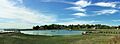
The mouth of the Bluefish River (left) seen from the shore of Duxbury Bay
|
|
| Country | United States |
| State | Massachusetts |
| Region | Duxbury |
| Physical characteristics | |
| River mouth | Duxbury Bay |
The Bluefish River is a stream in Duxbury, Massachusetts. It flows into a tidal river estuary, which is where the river meets the ocean and is affected by tides. This area was once a very busy place for shipbuilding in the early 1800s.
The river starts from small ponds near Patridge Road and Washington Street. It's about a third of a mile from Hall's Corner in Duxbury. A stream called Hounds Ditch Brook also flows into the Bluefish River at its estuary.
The Bluefish River is important for fish. It has a special "fish run" for anadromous fish. These are fish that live in the ocean but swim up rivers to lay their eggs. There's even a privately-owned fish ladder south of Harrison Street to help them.
A large part of the northern side of the Bluefish River estuary is a protected area. It's called the Capt. David Cushman Preserve. The Wildlands Trust takes care of it. You can find walking trails there with great views of the river and bay. Near its end, the river flows under the stone Bluefish River Bridge. This bridge is a local landmark and part of the Old Shipbuilder's Historic District. The river then empties into Duxbury Bay.
Contents
Discovering the Bluefish River's Past
Duxbury, Massachusetts, was settled a long time ago in 1628. It was part of the Plymouth Colony. The Bluefish River got its name very early on. According to Justin Winsor, Duxbury's first historian, many bluefish were found in its waters. The name "Bluefish River" was even written in old records as early as 1639.
Some of the first settlers built their homes along the Bluefish River. One famous settler was John Alden. He was given land on the north side of the river in 1628 and built his house there. Much of Alden's land later went to Capt. David Cushman. Today, this property is cared for by the Wildlands Trust. It's now a conservation area with walking trails for everyone to enjoy.
Building the Bluefish River Bridge
In 1803, important shipbuilders in Duxbury wanted a bridge over the Bluefish River. People like Ezra Weston I, Joshua Winsor, and Seth Sprague pushed for it. Shipyards and businesses were on both sides of the river. Merchants didn't want to travel all the way around the estuary to get to the other side.
Building the bridge caused a lot of arguments at Duxbury town meetings. But eventually, shipbuilder Joshua Winsor agreed to build the bridge for half the cost. Ezra Weston I, who really wanted the bridge, was nicknamed "King Caesar." This was because he was very determined at the town meetings. His son, Ezra Weston II, later got this nickname too. He became one of the richest and most successful shipbuilders in New England.
Ezra Weston II's house is known as the King Caesar House. It's a famous local landmark and a museum today. The Duxbury Rural and Historical Society owns it. You can find it right at the mouth of the Bluefish River. The first bridge was made of wood. But in 1883, a new stone bridge was built, which is the one you see today.
Shipbuilding on the Bluefish River

From the early to mid-1800s, the Bluefish River estuary was a busy industrial area. Six shipyards were built there. They made large sailing ships. There were also forges (places where metal is shaped), rope walks (where ropes were made), sail lofts (where sails were sewn), and other buildings related to shipbuilding.
Ezra Weston II had a shipyard on the south side of the estuary. He launched many ships from there. One of his most famous ships was the Hope, launched in 1841. It was the largest merchant ship built in New England at that time.
However, things changed. A financial crisis in 1837, called the Panic of 1837, caused many shipyards to close. More shipyards closed after the American Civil War because shipbuilding moved to bigger cities like Boston. By the early 1900s, the shores of the Bluefish River were full of old, broken-down buildings.
The Duxbury Rural and Historical Society worked hard in the 1910s to clean up the area. They wanted to bring it back to its natural beauty. Today, the wide salt marshes in the estuary show no signs of the busy industrial past. It's hard to imagine that ships were once built there!
Images for kids
-
Bluefish River estuary in Duxbury, Massachusetts
