Bow Hill, Sussex facts for kids
Quick facts for kids Bow Hill |
|
|---|---|

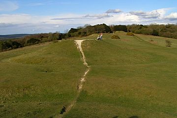
The Devil's Humps barrows on Bow Hill.
|
|
| Highest point | |
| Elevation | 206 m (676 ft) |
| Prominence | 74 m (243 ft) |
| Listing | Tump |
| Geography | |
| Location | South Downs |
| Parent range | Butser Hill |
| OS grid | SU 8244 1121 |
| Topo map | OS Landranger 197, Explorer OL8, 120 |
Bow Hill is a long, tall hill in the beautiful South Downs area of West Sussex, England. It stands about 206 meters (676 feet) high. This makes it a great spot for exploring nature and history!
Contents
Where is Bow Hill Located?
Bow Hill is the highest point on a place called Stoughton Down. It's found just east of the village of Stoughton in West Sussex. The very top of the hill is about 2 kilometers (1.2 miles) east of Stoughton. It's also about 7 kilometers (4.3 miles) northwest of the bigger town of Chichester.
To the south of Bow Hill, you'll find Stoke Down and the village of West Stoke. If you look east or southeast, you'll see the villages of West Dean and Mid Lavant. These villages are in the valley of the River Lavant. To the north are East Marden and Chilgrove.
What Does Bow Hill Look Like?
Bow Hill is the highest part of a long ridge that runs from north to south. It has steep sides. At the very top, there's a special marker called a trig point. This helps people know the exact height of the hill.
The top and upper parts of Bow Hill are covered in thick woods. But as you go down the slopes, the land opens up into grassy areas called downland. Many paths and trails run near the top of the hill. There's even a special path called a ridgeway that splits off near the summit. One way leads to Stoughton, and the other goes towards West Stoke.
Discovering History on Bow Hill
Much of Bow Hill is part of a nature reserve, which helps protect its natural beauty. Even though the very top isn't in the reserve, the whole area is full of amazing history. You can find lots of clues that ancient people lived here long ago.
Ancient Earthworks and Burial Mounds
On Bow Hill, you can see signs of old settlements. These include a cross dyke, which is a ditch and bank used as a boundary. There are also many tumuli, which are ancient burial mounds. Some of these are long barrows, which are long, rectangular mounds where people were buried.
Goosehill Camp: An Iron Age Fort
One really interesting spot is Goosehill Camp. This was an Iron Age hillfort. It's located about 1,500 meters (almost a mile) north-northeast of Bow Hill. This fort was built by people living around 800 BC to 100 AD. They used it for protection and as a place to live.
The Devil's Humps: Bronze Age Burials
Another important site is called the Devil's Humps. This is a group of four Bronze Age barrows. The Bronze Age was a time from about 3300 BC to 1200 BC. These barrows are also ancient burial mounds. They show us how people honored their dead thousands of years ago.
 | Delilah Pierce |
 | Gordon Parks |
 | Augusta Savage |
 | Charles Ethan Porter |

