Bow Island facts for kids
Quick facts for kids
Bow Island
|
|
|---|---|
|
Town
|
|
| Town of Bow Island | |

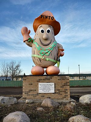
Pinto MacBean
|
|
| Country | Canada |
| Province | Alberta |
| Region | Southern Alberta |
| Census division | 1 |
| Municipal district | County of Forty Mile No. 8 |
| Incorporated | |
| • Village | June 14, 1910 |
| • Town | February 1, 1912 |
| Area
(2021)
|
|
| • Land | 5.68 km2 (2.19 sq mi) |
| Elevation | 799 m (2,621 ft) |
| Population
(2021)
|
|
| • Total | 2,036 |
| • Density | 358.5/km2 (929/sq mi) |
| Time zone | UTC−7 (MST) |
| • Summer (DST) | UTC−6 (MDT) |
| Postal code span |
T0K 0G0
|
| Area code(s) | 1+403 |
| Highways | Highway 3 |
| Waterway | South Saskatchewan River |
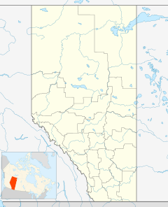
Bow Island (/boʊ/) is a town in Alberta, Canada. It is located on Highway 3 in southern Alberta. The town is about 100 km (62 mi) north of the U.S. border. It is also 320 km (200 mi) southeast of Calgary and 51 km (32 mi) southwest of Medicine Hat.
Contents
History of Bow Island
The first families settled in the Bow Island area around 1900. In February 1910, the community officially became the Village of Bow Island. Just two years later, in March 1912, it was declared the Town of Bow Island.
There are many stories about how Bow Island got its name. One popular story says that the names of Bow Island and Grassy Lake were mixed up. There is an island called "Bow Island" north of Grassy Lake. This island is near where the Bow River and the Oldman River meet. Meanwhile, a low, grassy area called "Grassy Lake" is actually south of Bow Island.
Bow Island was one of the first towns in Alberta to have its own natural gas wells. The town ran these wells for a while. Later, they sold the gas service to a private company.
In the early 1950s, a system to bring water for farming (irrigation) came to the Bow Island area. This helped the town's population double. Today, Bow Island is surrounded by 110,000 acres (445 km2) of very productive farmland. Some of the most advanced irrigation systems in the world are used here. The first pivot and linear sprinkler systems in Canada were set up near Bow Island. In 1982, the St. Mary River Irrigation District (SMRID) installed a fully automated water system. This system, called the Lateral 12 System, waters 5,000 acres (20 km2) and has been visited by groups from all over the world.
Where is Bow Island?
Bow Island is located between the cities of Lethbridge and Medicine Hat. The closest small community to Bow Island is the Hamlet of Burdett. The town of Bow Island is part of Forty Mile County.
People in Bow Island
In 2021, the Town of Bow Island had a population of 2,036 people. These people lived in 674 homes. This was a small increase from its 2016 population of 1,983. The town covers a land area of 5.68 km2 (2.19 sq mi). This means there were about 358.5/km2 (929/sq mi) people per square kilometer in 2021.
What is the Economy of Bow Island?
Bow Island is famous for its dry edible bean industry. You can see a huge 5.5-meter (18 ft) tall statue of the town's mascot, "Pinto MacBean," next to Highway No. 3. He welcomes everyone to town!
Bow Island is also the biggest area in Canada for growing spearmint. Four farms nearby produce about 25% of all the Scotch spearmint essential oil needed in North America. This oil is used to flavor candy, gum, mints, and toothpaste.
In 2019, a new factory opened in Bow Island to process mustard seeds. This building used to be home to Spitz, a company that started making sunflower seeds there in 1982. Spitz was sold to PepsiCo in 2008, and their production moved out in 2018.
Arts and Culture in Bow Island
"Blues at the Bow Live" is a very popular live blues music venue. It is located in the historic Bow Theatre. This place is known around the world for featuring Grammy and Juno Award winning blues artists.
This blues society started in 1993. It is a non-profit group run completely by volunteers. Their first show at the Bow Theatre was on December 17, 1994. Since then, they have hosted many sold-out performances. People come from all over Alberta and even further away to enjoy the blues music at Bow Island.
Schools in Bow Island
Bow Island has several schools for students.
- Public Schools:
* Senator Gershaw School teaches Grades 4 to 12. * Bow Island Elementary School teaches Kindergarten to Grade 3. * These schools are part of the Prairie Rose School Division.
- Catholic School:
* St. Michael's School is a Catholic school that teaches children from Pre-Kindergarten to Grade 12. * It is part of Holy Spirit Catholic Schools.
- Private Christian Schools:
* Cherry Coulee Christian Academy is a private Christian school. * Sun Country Christian School is a Mennonite Christian school. It is located just south of Centennial Park.
Famous People from Bow Island
Some notable people have come from Bow Island:
- Troy Loney, a former professional hockey player
- Clyfford Still, a famous artist
- Skyler Stromsmoe, a professional baseball player
- Nicholas Taylor, a former Canadian senator
Climate in Bow Island
| Climate data for Bow Island | |||||||||||||
|---|---|---|---|---|---|---|---|---|---|---|---|---|---|
| Month | Jan | Feb | Mar | Apr | May | Jun | Jul | Aug | Sep | Oct | Nov | Dec | Year |
| Record high °C (°F) | 15.2 (59.4) |
19.0 (66.2) |
25.4 (77.7) |
30.8 (87.4) |
33.2 (91.8) |
34.5 (94.1) |
36.6 (97.9) |
39.5 (103.1) |
35.6 (96.1) |
29.4 (84.9) |
24.2 (75.6) |
16.3 (61.3) |
39.5 (103.1) |
| Mean daily maximum °C (°F) | −2.3 (27.9) |
0.4 (32.7) |
5.3 (41.5) |
12.8 (55.0) |
18.5 (65.3) |
22.2 (72.0) |
26.6 (79.9) |
26.2 (79.2) |
20.9 (69.6) |
13.2 (55.8) |
4.6 (40.3) |
−1.3 (29.7) |
12.3 (54.1) |
| Mean daily minimum °C (°F) | −13.4 (7.9) |
−12.3 (9.9) |
−6.7 (19.9) |
−0.9 (30.4) |
4.7 (40.5) |
9.1 (48.4) |
11.2 (52.2) |
10.2 (50.4) |
5.7 (42.3) |
−0.2 (31.6) |
−7.1 (19.2) |
−12.3 (9.9) |
−1.0 (30.2) |
| Record low °C (°F) | −43.5 (−46.3) |
−37.7 (−35.9) |
−39.2 (−38.6) |
−19.3 (−2.7) |
−9.1 (15.6) |
0.2 (32.4) |
0.0 (32.0) |
1.1 (34.0) |
−8.5 (16.7) |
−21.0 (−5.8) |
−35.8 (−32.4) |
−39.6 (−39.3) |
−43.5 (−46.3) |
| Source: weatherstats.ca | |||||||||||||
See also
 In Spanish: Bow Island para niños


