
Bremenium facts for kids
Quick facts for kids Bremenium |
|
|---|---|
| Northumberland, England, UK | |

Western gateway to Bremenium
|
|

Bremenium
Location in Northumberland
|
|
| Coordinates | 55°16′52″N 2°15′50″W / 55.281°N 2.264°W |
Bremenium was an ancient Roman fort (a type of military camp called a castrum). It was located at Rochester in Northumberland, England. This fort was one of many strongholds built along Dere Street. Dere Street was an important Roman road that stretched from York all the way to Corbridge and then further north to Melrose. What makes Bremenium interesting is that it was built a long way north of Hadrian's Wall.
The name Bremenium is mentioned in several old Roman texts. These include the Ravenna Cosmography, the Antonine Itinerary, and Ptolemy’s Geographia. Another Roman road also ran east from Bremenium. It went to the Roman fort at Learchild, where it connected with the Devil's Causeway Roman road, which led to Berwick upon Tweed.
Contents
Where is Bremenium?
The fort is located in the small village of Rochester. This is about five miles (8 km) northwest of Otterburn. You can find it along the A68 road, which connects Corbridge and Jedburgh.
The Romans chose a very strong position for the fort. It sits at the end of a ridge. The ground drops steeply to the north and west. This gave the soldiers a clear view over the Rede Valley and the surrounding area. This made it easy to spot anyone coming towards the fort.
What did the Fort Look Like?
Bremenium is about 8.5 miles (13.7 km) north of Risingham, which was the previous fort on Dere Street. The name Bremenium means 'The Place of the Roaring Stream'.
The fort was shaped like an oblong. It measured about 485 feet (148 meters) from north to south and 445 feet (136 meters) from east to west. This covered an area of just over 5 acres (20,000 square meters). There was a gate in each of the four walls. The walls were made of stone and had an earth bank behind them.
It seems that an earlier fort with turf walls was built here first. Later, a stone fort replaced it. This happened when Quintus Lollius Urbicus was the Governor of Britain. He visited Bremenium on his way north to build the Antonine Wall in 142 AD. The fort remained in use even after the Antonine Wall was abandoned in the early 160s.
Bremenium was unusual because it had special defenses for artillery in the 3rd century. Its walls were thicker than most Roman forts. They also had stone platforms that stuck out about 32 feet (9.8 meters) from the wall. These platforms held large machines that could throw missiles. These machines were like smaller versions of a ballista and were called 'onagri'. They got their power from twisted ropes made of hair. From the north walls, these machines could fire missiles at anyone trying to advance down Dere Street from the north.
Who Guarded the Fort?
In the 2nd century, the fort was guarded by two different groups of soldiers:
- The First Cohort of Lingones: These soldiers were partly mounted (meaning some rode horses) and numbered 500 strong.
- The First Cohort of Dalmatians: These were infantry soldiers (foot soldiers).
In the 3rd century, the fort's garrison was the First Cohort of Vardulians. This group was also partly mounted and was much larger, with one thousand soldiers.
Bremenium Today
Today, the fort is part of the village green in Rochester. You can still see some parts of it. The west wall is the best preserved. It stands as a nine-feet-high bank with stone on its outer side. The west gate is still mostly complete, up to where its arch would have begun. However, much of the stone from the fort has been taken over the years to build local houses and other structures.
Digging Up the Past
Archaeological digs were carried out at Bremenium in 1852 and 1855. Unfortunately, these early excavations were not well recorded. A smaller dig also took place in 1935. These excavations showed that the inside of the fort was packed with buildings. Many of these buildings even had hypocausts, which were ancient Roman underfloor heating systems.
Images for kids
-
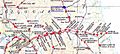
High Rochester and nearby forts
-
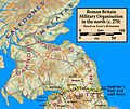
Forts in northern Britain in 270 AD
-
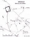
High Rochester surroundings and cemetery
-
Defensive ditches at High Rochester
-
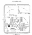
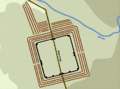
Bremenium groundplan (1902)


