Briones Regional Park facts for kids
Quick facts for kids Briones Regional Park |
|
|---|---|

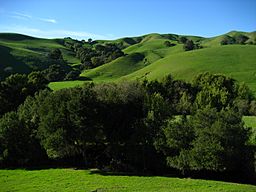
Briones Hills in Briones Regional Park
|
|
| Lua error in Module:Location_map at line 420: attempt to index field 'wikibase' (a nil value). | |
| Location | Briones Hills, Contra Costa County |
| Area | 6,117-acre (24.75 km2) |
Briones Regional Park is a huge park in California. It covers about 6,117-acre (24.75 km2) of land! This park is part of the East Bay Regional Park District (EBRPD) system. You can find it in the Briones Hills of central Contra Costa County. It's a popular spot in the San Francisco Bay Area for outdoor fun.
Contents
What is Briones Regional Park Like?
This park is in the rolling hills of the East Bay region. It is close to cities like Martinez, Lafayette, Walnut Creek, and Pleasant Hill. The western part of the park is right next to the Briones Reservoir. This reservoir is managed by EBMUD.
What Can You See from Briones Peak?
The highest point in the park is Briones Peak. It stands at 1,483 feet (452 meters) tall. From the top, you get amazing views! You can see Mount Diablo and the Diablo Valley to the east. To the north, you might spot the Sacramento River. Looking west, you can see the Berkeley Hills and Mount Tamalpais.
What Animals Live in the Park?
Briones Regional Park is home to many animals and birds. You might see turkey vultures flying high above. Black-tailed deer often roam through the hills. There are also cougars, coyotes, squirrels, and red-tailed hawks.
Some parts of the park are still used by ranchers. They raise cattle, sheep, and goats here. This tradition has been going on for a long time.
Exploring Lafayette Ridge
Lafayette Ridge is a special area inside Briones Park. It runs right next to the city of Lafayette. The Lafayette Ridge Trail is about 2 miles (3.2 km) long. It starts near Springhill Elementary School.
The trail goes up to the top of Russel Peak, which is 1,357 feet (414 meters) high. From there, the trail splits into two paths. These are the Russel Peak Trail and the Briones Crest Trail. Many other trails also branch off from Lafayette Ridge Trail. These include the Springhill and Buckeye Ranch Trails. The trails on the ridge are great for mountain biking. They have ups and downs of up to 200 feet (61 m) in elevation.
When Was Briones Park Created?
The land where Briones Park is today has a long history. In 1842, it was part of a Mexican land grant. This grant was given to the family of Felipe Briones. The Briones family started cattle ranching here. This activity still happens in the park today. In 1870, the Briones family sold their ranch.
By 1850, Happy Valley Road was very important. This road runs along the edge of Briones Regional Park. It was the main route from Martinez south to the city of San José. From San José, people could then travel up to San Francisco.
In 1909, a company bought the land. This company was called the Peoples' Water Company. It later became the East Bay Municipal Utility District. They bought the land to protect the water supply.
Since 1966, the University of California has used a part of the Briones Hills. This area is called the Russell Reservation. It is 283-acre (1.15 km2) big. The university uses it as a place for research.
Briones Regional Park officially opened in October 1967. It was established by the East Bay Regional Park District.
See also
 In Spanish: Parque regional Briones para niños
 | Precious Adams |
 | Lauren Anderson |
 | Janet Collins |


