
Broadalbin, New York facts for kids
Quick facts for kids
Broadalbin, New York
|
|
|---|---|

Broadalbin, New York
Location in New York
|
|
| Country | United States |
| State | New York |
| County | Fulton |
| Government | |
| • Type | Town Council |
| Area | |
| • Total | 39.78 sq mi (103.03 km2) |
| • Land | 31.72 sq mi (82.16 km2) |
| • Water | 8.06 sq mi (20.87 km2) |
| Elevation | 840 ft (260 m) |
| Population
(2010)
|
|
| • Total | 5,260 |
| • Estimate
(2016)
|
5,160 |
| • Density | 162.66/sq mi (62.81/km2) |
| Time zone | UTC-5 (Eastern (EST)) |
| • Summer (DST) | UTC-4 (EDT) |
| ZIP code |
12025
|
| Area code(s) | 518 and 838 |
| FIPS code | 36-035-08433 |
| GNIS feature ID | 978755 |
Broadalbin is a town in Fulton County, New York. It is located on the eastern side of the county. The town was named after the Breadalbane Region in Scotland by one of the first people to settle there. Broadalbin also has a smaller area inside it called a village, which is also named Broadalbin. In 2010, about 5,260 people lived in the town.
Contents
History of Broadalbin
The area that is now Broadalbin was part of a large land grant called the Sacandaga Patent from 1741. The first European settlers arrived around 1770. They built their homes near where the village of Broadalbin is today.
During the American Revolutionary War, a small fort called Castle Cumberland was built in the town. It was only used for a short time.
Broadalbin became its own town in 1793. It was formed from parts of two other towns, Johnstown and Mayfield. Later, parts of Broadalbin were used to create new towns. In 1799, the town of Northampton was formed. In 1842, the southern part of Broadalbin became the town of Perth.
In 1930, a large lake called Great Sacandaga Lake was created. Some of Broadalbin's land, including a marshy area called the Sacondaga Vlaie, was covered by the new lake.
Geography of Broadalbin
Broadalbin is located on the eastern edge of Fulton County. It is also at the southern end of the large Great Sacandaga Lake. The eastern border of the town is also the border of Saratoga County. A small part of the town is inside the Adirondack Park, a large protected natural area.
The town covers a total area of about 102.9 square kilometers (39.78 square miles). Most of this area, about 82.2 square kilometers (31.72 square miles), is land. The rest, about 20.9 square kilometers (8.06 square miles), is water.
New York State Route 29 is a main road that goes through the middle of Broadalbin. This road goes east to Saratoga Springs and west to Johnstown. Johnstown is the main town in Fulton County.
Population Information
In 2010, the population of Broadalbin was 5,260 people. The town has grown over many years.
| Historical population | |||
|---|---|---|---|
| Census | Pop. | %± | |
| 1820 | 2,428 | — | |
| 1830 | 2,657 | 9.4% | |
| 1840 | 2,738 | 3.0% | |
| 1850 | 2,476 | −9.6% | |
| 1860 | 2,534 | 2.3% | |
| 1870 | 2,492 | −1.7% | |
| 1880 | 2,175 | −12.7% | |
| 1890 | 2,021 | −7.1% | |
| 1900 | 1,946 | −3.7% | |
| 1910 | 1,845 | −5.2% | |
| 1920 | 1,949 | 5.6% | |
| 1930 | 2,226 | 14.2% | |
| 1940 | 2,300 | 3.3% | |
| 1950 | 2,543 | 10.6% | |
| 1960 | 2,945 | 15.8% | |
| 1970 | 3,542 | 20.3% | |
| 1980 | 4,074 | 15.0% | |
| 1990 | 4,397 | 7.9% | |
| 2000 | 5,066 | 15.2% | |
| 2010 | 5,260 | 3.8% | |
| 2016 (est.) | 5,160 | −1.9% | |
| U.S. Decennial Census | |||
In 2000, there were 1,951 households in the town. About 35.5% of these households had children under 18 living there. Most households were married couples living together. The average household had about 2.59 people.
The median age of people in the town was 38 years old. About 27.1% of the population was under 18 years old.
Places in Broadalbin
Here are some of the communities and locations you can find in the town of Broadalbin:
- Beatty Corners – A small area in the southern part of the town.
- Benedict – A hamlet (small settlement) located east of North Broadalbin.
- Broadalbin – Most of the village of Broadalbin is in this town. A small part is in the nearby town of Mayfield.
- Fish House – A hamlet located right on the shore of Great Sacandaga Lake. It is in the northeastern part of the town.
- Gorthey Corners – An area southwest of North Broadalbin.
- Hill Corners – A location in the southwestern part of the town.
- Hoesville – A hamlet found at the eastern border of the town.
- Honeywell Corners – A location in the southeastern part of the town.
- Mills Corners – An area north of NY-29. It is also sometimes called "Flea Hill."
- North Broadalbin (formerly "Averys" and "Spencers Corners") – A hamlet on the shore of Great Sacandaga Lake.
- Sand Island – A small island in the Great Sacandaga Lake, north of North Broadalbin.
- Steeles Corners – A location north of Mills Corners.
- Stever Mill – A location east of Broadalbin village.
- Union Mills – A hamlet near the eastern town line. It started in 1827 when a saw mill was built there.
Images for kids
-
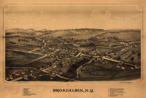
A drawing of Broadalbin from 1880, showing important places.
See also
 In Spanish: Broadalbin (Nueva York) para niños
