Brownsdale, Minnesota facts for kids
Quick facts for kids
Brownsdale, Minnesota
|
|
|---|---|
| Motto(s):
"Garden Spot of Mower County"
|
|

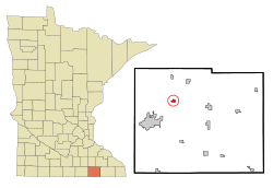
Location in Mower County and the state of Minnesota
|
|
| Country | United States |
| State | Minnesota |
| County | Mower |
| Area | |
| • Total | 0.40 sq mi (1.0 km2) |
| • Land | 0.40 sq mi (1.0 km2) |
| • Water | 0.0 sq mi (0 km2) |
| Elevation | 1,293 ft (394 m) |
| Population
(2020)
|
|
| • Total | 633 |
| • Density | 1,566.83/sq mi (604.23/km2) |
| Time zone | UTC-6 (Central (CST)) |
| • Summer (DST) | UTC-5 (CDT) |
| ZIP code |
55918
|
| Area code(s) | 507 |
| FIPS code | 27-08164 |
| GNIS feature ID | 2393440 |
Brownsdale is a small city located in Mower County, Minnesota, in the United States. In 2020, about 633 people lived there.
Contents
History of Brownsdale
Brownsdale started as a planned community in 1856. It was named after Andrew D. Brown, who was a businessman in the lumber industry. A post office opened here in 1857. Brownsdale officially became a city in 1876.
Geography of Brownsdale
Brownsdale is located in the northwest part of Mower County. It's about 9 miles (14 km) northeast of Austin, which is the main city in the county. Brownsdale is its own city, even though it's surrounded by Red Rock Township.
Minnesota State Highway 56 goes right through the middle of Brownsdale. This highway leads north about 6 miles (10 km) to Waltham. It also goes south about 4.5 miles (7.2 km) to Interstate 90 near Nicolville.
According to the U.S. Census Bureau, Brownsdale covers an area of 0.40 square miles (1.04 square kilometers). All of this area is land. The northern part of the city drains into Roberts Creek. The southern part drains into Wolf Creek. Both of these creeks flow west and eventually join the Cedar River.
Population of Brownsdale
| Historical population | |||
|---|---|---|---|
| Census | Pop. | %± | |
| 1880 | 346 | — | |
| 1890 | 282 | −18.5% | |
| 1900 | 261 | −7.4% | |
| 1910 | 264 | 1.1% | |
| 1920 | 271 | 2.7% | |
| 1930 | 273 | 0.7% | |
| 1940 | 355 | 30.0% | |
| 1950 | 493 | 38.9% | |
| 1960 | 622 | 26.2% | |
| 1970 | 625 | 0.5% | |
| 1980 | 691 | 10.6% | |
| 1990 | 695 | 0.6% | |
| 2000 | 718 | 3.3% | |
| 2010 | 676 | −5.8% | |
| 2020 | 633 | −6.4% | |
| U.S. Decennial Census | |||
Population in 2010
In 2010, the city of Brownsdale had 676 people living there. There were 286 households and 190 families. The city had about 1438 people per square mile (555 per square kilometer).
Most of the people in Brownsdale were White (98.1%). A small number were from other races (1.3%) or two or more races (0.4%). About 5.5% of the population was Hispanic or Latino.
About 30% of the households had children under 18 living with them. Nearly half (48.6%) were married couples. About 13% had a female head of household with no husband. Around 4.5% had a male head of household with no wife. About 25% of all households were individuals living alone. Of these, 14.7% were people aged 65 or older.
The average age in Brownsdale was 41.4 years. About 24.6% of residents were under 18. About 17.8% were 65 years or older. The population was 46.7% male and 53.3% female.
See also
 In Spanish: Brownsdale (Minnesota) para niños
 | Ernest Everett Just |
 | Mary Jackson |
 | Emmett Chappelle |
 | Marie Maynard Daly |

