Waltham, Minnesota facts for kids
Quick facts for kids
Waltham, Minnesota
|
|
|---|---|

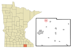
Location in Mower County and the state of Minnesota
|
|
| Country | United States |
| State | Minnesota |
| County | Mower |
| Area | |
| • Total | 0.48 sq mi (1.24 km2) |
| • Land | 0.48 sq mi (1.24 km2) |
| • Water | 0.00 sq mi (0.00 km2) |
| Elevation | 1,319 ft (402 m) |
| Population
(2020)
|
|
| • Total | 164 |
| • Density | 343.10/sq mi (132.48/km2) |
| Time zone | UTC-6 (Central (CST)) |
| • Summer (DST) | UTC-5 (CDT) |
| ZIP code |
55982
|
| Area code(s) | 507 |
| FIPS code | 27-67918 |
| GNIS feature ID | 2397185 |
Waltham is a small city located in Mower County, Minnesota, in the United States. In 2020, the city had a population of 164 people. It's a quiet community in the heart of Minnesota.
Contents
History of Waltham
Waltham was officially established in 1885. It was named after a city called Waltham, Massachusetts, which is much larger. When a town is "platted," it means its streets and lots are officially mapped out.
Where is Waltham Located?
Waltham is in the northwestern part of Mower County. It's surrounded by a larger area also called Waltham Township, but the city itself is a separate place.
How to Get to Waltham
Minnesota State Highway 56 runs right along the eastern edge of the city. This highway can take you north about 5 miles to Hayfield. If you go south on the same highway, you'll reach Brownsdale, also about 5 miles away.
Nearby Cities and Natural Features
The city of Austin is the main city in Mower County. It's about 15 miles southwest of Waltham. You can get there using Highway 56 and Interstate 90. Waltham's land drains towards the west, into the Cedar River. This river eventually flows into the Iowa River.
What is Waltham's Size?
Waltham covers a total area of about 0.48 square miles (1.24 square kilometers). All of this area is land, meaning there are no lakes or large rivers within the city limits.
Population Changes in Waltham
The number of people living in Waltham has changed over many years. Here's a look at how the population has grown and shrunk:
| Historical population | |||
|---|---|---|---|
| Census | Pop. | %± | |
| 1900 | 150 | — | |
| 1910 | 170 | 13.3% | |
| 1920 | 180 | 5.9% | |
| 1930 | 190 | 5.6% | |
| 1940 | 172 | −9.5% | |
| 1950 | 212 | 23.3% | |
| 1960 | 207 | −2.4% | |
| 1970 | 189 | −8.7% | |
| 1980 | 176 | −6.9% | |
| 1990 | 170 | −3.4% | |
| 2000 | 196 | 15.3% | |
| 2010 | 151 | −23.0% | |
| 2020 | 164 | 8.6% | |
| U.S. Decennial Census | |||
Waltham's Population in 2010
In 2010, the census counted 151 people living in Waltham. There were 67 households, which are like homes or families living together. About 40 of these were families.
The city had about 328 people per square mile. There were 73 housing units, which means places where people could live.
Most of the people in Waltham were White (97.4%). A small number were Asian (0.7%), and 2.0% were from two or more races. About 2.0% of the population identified as Hispanic or Latino.
Who Lives in Waltham's Homes?
Out of the 67 households:
- About 23.9% had children under 18 living there.
- Nearly half (49.3%) were married couples living together.
- A small number had a female head of household (4.5%) or a male head of household (6.0%) without a spouse.
- About 40.3% were non-families, meaning individuals or groups of unrelated people living together.
- About 31.3% of all households were just one person living alone.
- Only 6% of households had someone aged 65 or older living by themselves.
The average household had 2.25 people, and the average family had 2.90 people.
Age and Gender in Waltham (2010)
The average age of people in Waltham in 2010 was 41.2 years old.
- 19.9% of residents were under 18.
- 7.1% were between 18 and 24.
- 28.5% were between 25 and 44.
- 33.1% were between 45 and 64.
- 11.3% were 65 years old or older.
When it came to gender, 54.3% of the population was male, and 45.7% was female.
See also
 In Spanish: Waltham (Minnesota) para niños
 | George Robert Carruthers |
 | Patricia Bath |
 | Jan Ernst Matzeliger |
 | Alexander Miles |

