Brownsville, Wisconsin facts for kids
Quick facts for kids
Brownsville, Wisconsin
|
|
|---|---|
|
Village
|
|

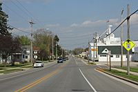
Looking east in Brownsville on Wisconsin Highway 49
|
|

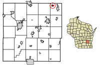
Location of Brownsville in Dodge County, Wisconsin.
|
|
| Country | United States |
| State | Wisconsin |
| County | Dodge |
| Area | |
| • Total | 0.61 sq mi (1.59 km2) |
| • Land | 0.61 sq mi (1.59 km2) |
| • Water | 0.00 sq mi (0.00 km2) |
| Elevation | 997 ft (304 m) |
| Population
(2020)
|
|
| • Total | 598 |
| • Density | 975.5/sq mi (376.7/km2) |
| Time zone | UTC-6 (Central (CST)) |
| • Summer (DST) | UTC-5 (CDT) |
| Area code(s) | 920 |
| FIPS code | 55-10450 |
| GNIS feature ID | 1562277 |
Brownsville is a small village in Dodge County, Wisconsin, United States. It is home to 598 people, according to the 2020 census.
Contents
History of Brownsville
Brownsville was first called Thetis Station. It had a special narrow gauge railroad that connected it to Fond du Lac and Iron Ridge.
In April 1878, the village was renamed Brownsville. This name honored Alfred D. Brown. He was an English immigrant and a pioneer farmer. In 1850, he settled an 80-acre farm nearby. He also became one of the first merchants in the area.
Brownsville officially became an incorporated village on December 23, 1952. So, 1878 is seen as the village's founding year. 1952 marks its start as a proper town.
As the village grew, more businesses opened. Farmers built places to store crops and a grain elevator. In 1902, a small factory was built. It was used to make cheese for many years. Later, a company called Michels Corporation bought it in 1965. The factory was taken down in 1973.
Brownsville Fire Department
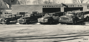
The Brownsville Fire Company started in 1891. It had 13 members and a wagon with a hand-operated water pump. The company was reorganized in October 1912.
In 1931, they bought their first mechanical fire truck. It was a Studebaker pump truck. This old truck is still kept safe today by a private owner. Today, the fire department uses modern equipment. They help with emergencies in Brownsville and nearby towns. They work with other emergency services in Dodge and Fond du Lac counties.
Local Church History
Saint Paul's Lutheran Church began in 1885. Fifteen families from a church in Lomira started their own group. They built their first church building in 1887. It was on Main Street, next to the cemetery. Sadly, a fire destroyed it on September 6, 1909.
In 1887, the church chose Mr. Gottmanshausen as their first pastor. Reverend Gottmanshausen began his work on June 25, 1887. The current church was built in June 1915. It is located one block from the cemetery. It was finished in November of that year and is still used today.
2018 Tornado Event
On August 28, 2018, a powerful EF1 tornado hit the village. It caused a lot of damage. The tornado pulled trees out of the ground. It ripped siding off buildings and damaged roofs. Power lines also fell down. The village declared a state of emergency. Residents were only allowed back into their homes days later.
Geography of Brownsville
Brownsville is located close to major roads. It is two miles from US Highway 41 and Wisconsin Highway 175. Wisconsin Highway 49 runs right through the village.
Kummel Creek starts just north of Brownsville. This creek flows through the village and into the Rock River. The Horicon Marsh is a large wetland area. It is about five miles west of Brownsville.
The village covers a total area of about 0.61 square miles (1.59 square kilometers). All of this area is land.
Population and People
| Historical population | |||
|---|---|---|---|
| Census | Pop. | %± | |
| 1960 | 276 | — | |
| 1970 | 374 | 35.5% | |
| 1980 | 433 | 15.8% | |
| 1990 | 415 | −4.2% | |
| 2000 | 570 | 37.3% | |
| 2010 | 581 | 1.9% | |
| 2020 | 598 | 2.9% | |
| U.S. Decennial Census | |||
The population of Brownsville has grown over the years. In 1960, there were 276 people. By 2020, the population had reached 598.
2010 Census Details
In 2010, there were 581 people living in Brownsville. These people lived in 221 households. Most of the households (70.1%) were married couples. About 37.6% of households had children under 18 living with them.
The average age in the village was 40.1 years. About 25% of residents were under 18 years old. About 11% were 65 years or older. The population was almost evenly split between males (50.6%) and females (49.4%).
Businesses and Services
Brownsville has many different businesses. You can find a bowling alley and a bar and grill. There is also an apple orchard, a bank, and a gas station. For health needs, there is a dentist and a medical clinic. This clinic is linked to SSM Health and Saint Agnes Hospital in Fond du Lac.
The main office for Michels Corporation is located in Brownsville. This is a large construction company.
Community Amenities
The village also has public places for everyone to enjoy. There is a local public library. You can also find two parks, baseball/softball fields, and soccer fields. A community center hosts local events. It can also be rented for private parties.
Public Services
Brownsville provides several important services to its residents. These include the local fire department and a public works department. There is also a police department with one officer. The village has its own post office. Inside the post office, you can see photos of local residents. These photos honor those who serve or have served in the United States Armed Forces. The village also manages its own water tower and a sewage treatment facility.
See also
 In Spanish: Brownsville (Wisconsin) para niños
 | Precious Adams |
 | Lauren Anderson |
 | Janet Collins |


