Broxburn, Queensland facts for kids
Quick facts for kids BroxburnQueensland |
|||||||||||||||
|---|---|---|---|---|---|---|---|---|---|---|---|---|---|---|---|

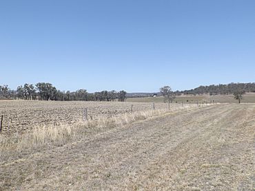
Farms along Southbrook Road, 2014
|
|||||||||||||||
| Population | 115 (2021 census) | ||||||||||||||
| • Density | 3.594/km2 (9.31/sq mi) | ||||||||||||||
| Postcode(s) | 4356 | ||||||||||||||
| Area | 32.0 km2 (12.4 sq mi) | ||||||||||||||
| Time zone | AEST (UTC+10:00) | ||||||||||||||
| Location |
|
||||||||||||||
| LGA(s) | Toowoomba Region | ||||||||||||||
| State electorate(s) | Condamine | ||||||||||||||
| Federal Division(s) | |||||||||||||||
|
|||||||||||||||
Broxburn is a small, quiet area in the countryside of Queensland, Australia. It is known as a rural locality and is part of the Toowoomba Region. In 2021, about 115 people lived there.
Contents
Broxburn's Location and Land
Broxburn is mostly made up of farmland. People here grow crops and let animals graze on the land.
The Gore Highway runs along the northwest edge of Broxburn. There's also an old railway line, the Millmerran railway line, near the northern border. An old train station called Greenhills used to be there, but it is not used anymore.
A Look at Broxburn's Past
Broxburn used to have its own schools.
Early Schools in Broxburn
The Broxburn Provisional School first opened its doors on June 13, 1898. A provisional school was a smaller, temporary school. In 1909, it became a full State School. However, it closed down in 1959. This school was located on Pittsworth Felton Road. Today, that spot is just inside the nearby town of Pittsworth.
Another school, Wilga View State School, opened later on July 4, 1938. It also closed in 1959, the same year as Broxburn State School.
Who Lives in Broxburn?
The number of people living in Broxburn has changed over the years.
Population Numbers
In 2016, about 153 people lived in Broxburn. By 2021, the population was 115 people. This shows that it is a very small community.
Broxburn's Economy
The main activity in Broxburn is farming. Many large farms, called homesteads, are located here.
Homesteads in Broxburn
Some of the homesteads in Broxburn include:
- Albion Park
- Dalhiem Park
- East Lynne
- Glenhaven
- Greystones
- Helgar Park
- Highland View
- Hulilou
- Nevertire
- Peppertree
- Rockmount
- Rogar Park
- Tullawood
Where Kids Go to School
There are no schools directly in Broxburn today.
Nearby Schools
Children living in Broxburn usually go to school in nearby towns. For primary school, they might attend Pittsworth State School in Pittsworth or Southbrook Central State School in Southbrook. For high school, students typically go to Pittsworth State High School, also in Pittsworth.
 | James Van Der Zee |
 | Alma Thomas |
 | Ellis Wilson |
 | Margaret Taylor-Burroughs |


