Buckleboo facts for kids
Quick facts for kids BucklebooSouth Australia |
|||||||||||||||
|---|---|---|---|---|---|---|---|---|---|---|---|---|---|---|---|

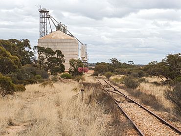
Former grain silos on Buckleboo Railway
|
|||||||||||||||
| Established | 17 December 1925 | ||||||||||||||
| Postcode(s) | 5641 | ||||||||||||||
| Time zone | ACST (UTC+9:30) | ||||||||||||||
| • Summer (DST) | ACST (UTC+10:30) | ||||||||||||||
| Location |
|
||||||||||||||
| LGA(s) |
|
||||||||||||||
| Region | Far North Eyre Western |
||||||||||||||
| County | Buxton | ||||||||||||||
| State electorate(s) | Flinders | ||||||||||||||
| Federal Division(s) | Grey | ||||||||||||||
|
|||||||||||||||
|
|||||||||||||||
| Footnotes | Adjoining localities | ||||||||||||||
Buckleboo is a small place in the Australian state of South Australia. It is located on the Eyre Peninsula, a large triangular peninsula on the coast. Buckleboo is about 313 kilometers (194 miles) northwest of Adelaide, which is the capital city of South Australia. It is also about 31 kilometers (19 miles) northwest of Kimba, a nearby town.
Contents
History of Buckleboo
Buckleboo started as a special type of settlement called a government town. It was officially planned in November 1924. The town was then proclaimed, or formally announced, on December 17, 1925. This was done by Tom Bridges, who was the Governor of South Australia at the time.
How Buckleboo Got Its Name
The town was named after the Hundred of Buckleboo. A "hundred" is an old way of dividing land in Australia, like a district. It helps to organize areas for things like farming and property.
Changes to Boundaries
Over the years, the official boundaries of Buckleboo have changed a few times. In 1989, some land was removed from the northwest part of the town. Later, in 1999, new boundaries were set for the wider area known as the locality of Buckleboo. This new area included the original government town and another former town called Moongi. In 2013, a piece of land from a nearby area, Pinkawillinie, was added to Buckleboo. This was done to make sure the entire area that was once part of the Buckleboo Pastoral Run (a large farm) was within the locality.
Buckleboo's Railway Past
Until 2005, Buckleboo was an important stop on the Eyre Peninsula Railway. This was a narrow gauge railway, which means its tracks were closer together than standard train tracks. The main job of this railway was to carry grain. Farmers would bring their harvested grain to Buckleboo, and it would be loaded onto trains. These trains would then travel through towns like Kimba and Cummins all the way to Port Lincoln. From Port Lincoln, the grain could be shipped to other places around the world.
Grain Silos and Buildings
Even though the railway is no longer active, you can still see the large grain silos at the former railway station. These silos were used to store the grain before it was loaded onto the trains. There are also a few other old buildings remaining from the railway days. These buildings and the silos are now surrounded by the Buckleboo Conservation Reserve.
Nature and Conservation Areas
The Buckleboo Conservation Reserve was created in 1990. A conservation reserve is a special area of land that is protected to help preserve its natural environment, including plants and animals. It's a place where nature can thrive.
Moongi Conservation Reserve
The Buckleboo area also includes another protected area called the Moongi Conservation Reserve. This reserve is located a bit further along where the railway was planned to go, even though tracks were never actually laid there. Moongi also had a small community in the past, with a school and a Methodist Hall that opened in 1932.
Sports and Community Life
Buckleboo is home to a place called 'Buckleboo Park'. This park is a great spot for sports and outdoor activities. It has six tennis courts where people can play tennis. There is also a large oval, which is a big grassy field. This oval is used for popular Australian sports like Australian rules football and cricket.
Government and Location
Buckleboo is part of different government areas. For national elections, it is in the federal division of Grey. For state elections in South Australia, it is in the state electoral district of Flinders.
The southern part of Buckleboo is managed by the District Council of Kimba. This is like the local government for that area. However, the northern part of Buckleboo is in a different kind of area called the Pastoral Unincorporated Area. This means it's a large rural area that doesn't have its own local council, so it's managed directly by the state government.
 | Claudette Colvin |
 | Myrlie Evers-Williams |
 | Alberta Odell Jones |


