Buffalo Creek (Monongahela River tributary) facts for kids
Quick facts for kids Buffalo Creek |
|
|---|---|

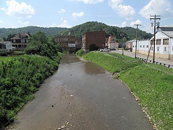
Buffalo Creek in Mannington in 2010
|
|
|
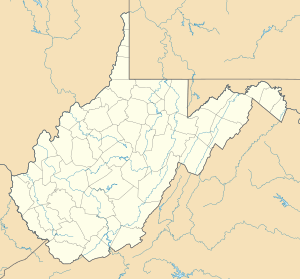
Location of the mouth of Buffalo Creek in Fairmont, West Virginia
|
|
| Country | United States |
| State | West Virginia |
| County | Marion |
| Physical characteristics | |
| Main source | near Brink 1,355 ft (413 m) 39°32′22″N 80°29′22″W / 39.5395288°N 80.4895332°W |
| River mouth | Monongahela River Fairmont 860 ft (260 m) 39°29′44″N 80°07′30″W / 39.4956401°N 80.1250769°W |
| Length | 30.2 mi (48.6 km) |
| Basin features | |
| Basin size | 125 sq mi (320 km2) |
| Tributaries |
|
Buffalo Creek is a river in northern West Virginia, United States. It is about 30.2 miles (48.6 km) long. This creek is a tributary of the Monongahela River. A tributary is a smaller stream or river that flows into a larger one.
Buffalo Creek is part of a huge river system. Its waters eventually flow into the Ohio River and then the mighty Mississippi River. This means it is part of the watershed of the Mississippi River. A watershed is an area of land where all the water drains into a single river or lake. Buffalo Creek's watershed covers about 125 square miles (320 km²). It is located entirely within Marion County.
Contents
Where Buffalo Creek Flows
Buffalo Creek starts near the western edge of Marion County. This area is close to a community called Brink. From there, the creek flows mostly towards the east.
Communities Along the Creek
As it travels, Buffalo Creek passes through several towns and communities. These include Logansport, Mannington, Rachel, Farmington, Pine Grove, and Barrackville. Finally, it reaches Fairmont. Here, Buffalo Creek joins the Monongahela River from the west.
Other Streams Joining Buffalo Creek
One important stream that flows into Buffalo Creek is Pyles Fork. Pyles Fork joins Buffalo Creek from the north when it reaches Mannington. After Mannington, a road called U.S. Route 250 runs alongside the creek for a long distance.
What the Land Around the Creek Looks Like
The land around Buffalo Creek is mostly covered in trees. The West Virginia Department of Environmental Protection has studied the area. They found that about 84% of the land in the Buffalo Creek watershed is forest. Most of these are deciduous forests, meaning the trees lose their leaves in the fall. The remaining 14% of the land is used for pasture (where animals graze) and agriculture (farming).
How Fast the Water Flows
The amount of water flowing in Buffalo Creek changes over time. Scientists measure this flow rate at a special station called a stream gauge. There is a stream gauge at Barrackville, which is about 4.4 miles (7.1 km) upstream from where the creek meets the Monongahela River.
Average and Extreme Flow Rates
- Between 1907 and 2012, the average flow of Buffalo Creek was about 169 cubic feet per second (5 cubic meters per second).
- The highest flow ever recorded was on February 19, 2000. On that day, the water rushed at 10,400 cubic feet per second (294 cubic meters per second)!
- The lowest flow recorded was 0 cubic feet per second (0 cubic meters per second). This means the creek completely dried up for a while in 1908.
 | Jessica Watkins |
 | Robert Henry Lawrence Jr. |
 | Mae Jemison |
 | Sian Proctor |
 | Guion Bluford |


