
Butler, Georgia facts for kids
Quick facts for kids
Butler, Georgia
|
|
|---|---|

Butler Municipal Building (aka City Hall)
|
|

Location in Taylor County and the state of Georgia
|
|
| Country | United States |
| State | Georgia |
| County | Taylor |
| Area | |
| • Total | 3.26 sq mi (8.45 km2) |
| • Land | 3.25 sq mi (8.41 km2) |
| • Water | 0.02 sq mi (0.04 km2) |
| Elevation | 628 ft (191 m) |
| Population
(2020)
|
|
| • Total | 1,881 |
| • Density | 579.48/sq mi (223.73/km2) |
| Time zone | UTC-5 (Eastern (EST)) |
| • Summer (DST) | UTC-4 (EDT) |
| ZIP code |
31006
|
| Area code(s) | 478 |
| FIPS code | 13-12120 |
| GNIS feature ID | 0312093 |
Butler is a small city in Georgia, United States. It is the main town, or county seat, of Taylor County. In 2020, about 1,881 people lived there.
Contents
History of Butler, Georgia
Early Beginnings and Railroads
The city of Butler started to grow around 1850. This was when the Central of Georgia Railway built its train tracks through the area. Today, the Norfolk Southern company owns these tracks. About three to four trains pass through Butler every day.
How Butler Became a City
Butler officially became a city on February 8, 1854. However, it took until 1870 for the city to get its official document, called a charter. Taylor County was created from land that once belonged to the Creek Indian territory. This land later became parts of Marion, Talbot, and Macon counties.
The "Fifty Mile Station"
Butler was chosen as a city location because it was a special spot on the railroad. It was known as the "Fifty Mile Station." This is because it was right in the middle of the railroad line between Macon and Columbus, Georgia. Both cities are about 50 miles (80 kilometers) away from Butler.
Naming the City of Butler
The city of Butler, Georgia, was named after a famous person. He was General William Orlando Butler. He was a brave soldier in the Mexican–American War. He also ran for Vice President with General Lewis Cass.
Modern Energy: Solar Power
In late 2016, a large solar power plant was built near Butler. This plant covers 1,070 acres and can produce 103 megawatts of electricity. It is called the Butler Solar Facility and is owned by First Solar. This shows how Butler is using modern technology for energy.
Geography and Location
Where is Butler Located?
Butler is located at coordinates 32.557 degrees North and 84.239 degrees West. This helps people find its exact spot on a map.
Main Roads and Routes
The city is on U.S. Route 19. This is the main road that goes through Butler. U.S. 19 goes north for about 28 miles (45 km) to Thomaston. It goes south for about 24 miles (39 km) to Ellaville.
The Fall Line Freeway (also known as GA-540) also passes through the southern part of Butler. It runs from west to east and shares its path with Georgia State Route 96. GA-540 and GA-96 go east for 9 miles (14 km) to Reynolds. They go west for 14 miles (23 km) to Junction City.
Another road, Georgia State Route 137, also goes through the city. It leads northeast for 20 miles (32 km) to Roberta. It goes southwest for 25 miles (40 km) to Buena Vista.
City Size and Water
According to the United States Census Bureau, Butler covers a total area of about 3.2 square miles (8.3 square kilometers). Most of this area is land. Only a very small part, about 0.31%, is water.
Population Changes Over Time
| Historical population | |||
|---|---|---|---|
| Census | Pop. | %± | |
| 1890 | 712 | — | |
| 1900 | 707 | −0.7% | |
| 1910 | 705 | −0.3% | |
| 1920 | 758 | 7.5% | |
| 1930 | 857 | 13.1% | |
| 1940 | 1,093 | 27.5% | |
| 1950 | 1,182 | 8.1% | |
| 1960 | 1,346 | 13.9% | |
| 1970 | 1,589 | 18.1% | |
| 1980 | 1,959 | 23.3% | |
| 1990 | 1,673 | −14.6% | |
| 2000 | 1,907 | 14.0% | |
| 2010 | 1,972 | 3.4% | |
| 2020 | 1,881 | −4.6% | |
| U.S. Decennial Census | |||
The population of Butler has changed over many years. In 1890, there were 712 people. The population grew steadily for many decades. By 1980, it reached its highest point with 1,959 people. In 2020, the population was 1,881 people. This shows how the number of people living in Butler has changed over time.
As of the 2020 United States census, there were 1,881 people living in Butler. These people lived in 762 households, and 447 of these were families.
Education in Butler
Taylor County School District
The Taylor County School District is in charge of schools in the area. It serves students from pre-school all the way to twelfth grade. The district has two elementary schools, one middle school, and one high school. There are 101 full-time teachers who help teach over 1,735 students.
- Taylor County Primary School
- Taylor County Upper Elementary
- Taylor County Middle School
- Taylor County High School
Record-Breaking Basketball Team
The Taylor County Girls' basketball team made history! From 1967 to 1972, they won 132 games in a row. This is the longest winning streak for a girls' high school basketball team in the entire nation. They were undefeated for five years and won five state championships in a row.
Notable People from Butler
- Ella Little-Collins: She was an important civil rights activist.
Gallery
-
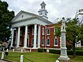
The Taylor County Courthouse was built in Butler in 1935. It is a historic building.
-
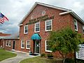
The Taylor County Government Complex.
-
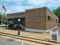
The Butler Post Office. Its ZIP code is 31006.
-
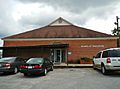
The Taylor County Board of Education building.
-
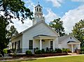
The Union Methodist Church and its cemetery are just north of Butler. They are also historic places.
-
The Taylor County Sheriff's Office.


.JPG)


See also
 In Spanish: Butler (Georgia) para niños
