Butternut Creek (Onondaga County) facts for kids
Quick facts for kids Butternut Creek |
|
|---|---|

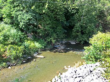
Butternut Creek at the Jamesville Road bridge
|
|
| Country | United States |
| State | New York |
| Physical characteristics | |
| Main source | Unnamed marsh Apuila Station 1,212 ft (369 m) 42°49′25″N 76°04′22″W / 42.82361°N 76.07278°W |
| River mouth | Limestone Creek Minoa 387 ft (118 m) 43°05′53″N 75°59′59″W / 43.09806°N 75.99972°W |
| Length | 16 mi (26 km) |
| Basin features | |
| Tributaries |
|
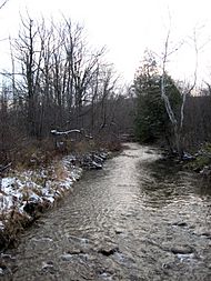
Butternut Creek is a cool stream near Syracuse, New York. It flows into Limestone Creek, which is part of the big Oneida Lake water system. The creek is about 16 miles (26 km) long.
Contents
Where Does Butternut Creek Flow?
Butternut Creek starts in a marshy area near Apulia Station. It begins as several small streams that flow down from nearby hills. The creek then flows north through a valley shaped by glaciers.
It passes into Jamesville Reservoir, a large lake. After the reservoir, it joins with Rush Creek. The creek then flows through the village of Jamesville. It also goes past Clark Reservation State Park.
Journey to Limestone Creek
The creek flows under Interstate 481. It meets the old Erie Canal near DeWitt. Here, another stream called Meadow Brook joins it. Butternut Creek then flows past the CSX train yards. It also goes under Interstate 90. Finally, it turns east and flows into Limestone Creek near Minoa.
The area that drains into Butternut Creek is about 75 square miles (194 km²). There are about 77.6 miles (125 km) of streams in this area. The water quality is good near Jamesville and upstream. However, closer to the end of the creek, the water has more nutrients. This comes from farms and water running off city areas.
How Glaciers Shaped the Land
The landscape around Butternut Creek was carved by huge glaciers. This happened during the last Ice Age, about 20,000 years ago. A thick sheet of ice covered the entire area.
As the ice melted about 12,000 years ago, a large lake formed. This was Glacial Lake Newbury. It was in the area where Syracuse is today. The lake's water eventually overflowed. This turned the lower part of Butternut Creek into a very big river. It connected to the Mohawk and Hudson River systems.
Waterfalls and Gorges
When all the ice melted, the water flowed north. It went into the Great Lakes and the Saint Lawrence River. This left behind dry "Syracuse channels." These are large breaks between the Butternut and Onondaga Creek valleys. It also created a 180-foot (55 m) cliff at Clark Reservation State Park. This cliff was once a giant waterfall fed by melting glaciers.
Near Jamesville, Butternut Creek has cut through the Onondaga Formation. This rock is about 550 million years old. The creek has created a steep and narrow gorge. The Jamesville Quarry is also located along the creek. It has dug out about 2,238 acres (906 ha) of the area.
A Look Back in Time
The Butternut Creek valley was an important place for the Onondaga people. This Native American group lived here for many years. In 1681, a French priest wrote about their main village. It was on the east side of the creek, south of present-day Jamesville. This area is now covered by the Jamesville Reservoir.
After some conflicts with French settlers, the Onondaga moved. They went south into the hills along the upper creek. Later, in the 1720s, they moved west to Onondaga Creek. The creek has several old Native American names. These include Ka-soongk-ta and Kashunkta.
Building the Aqueduct and Reservoir
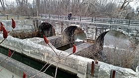
In 1856, the first Butternut Creek Aqueduct was built. This structure carried the Erie Canal over the creek. The original wooden aqueduct was later replaced. The new one is a stone and concrete bridge. It is about 80 feet (24 m) long.

The Jamesville Reservoir was built in 1874. Its purpose was to provide water for the Erie Canal. This was especially important during dry seasons. The reservoir holds about 224 acres (91 ha) of water. It can hold about 4,000 acre-feet (4.9 million m³) of water. Jamesville Beach County Park is next to the reservoir. It is a popular place for swimming.
In the 1970s, the Jamesville Dam had cracks. The reservoir was drained for a while so repairs could be made. In 1974, the creek had record flooding. The water rose to 7.84 feet (2.39 m). This caused flooding in parts of DeWitt. Some parts of the creek were changed to control floods. This happened when Interstate 481 was built in the 1970s.
In 2012, the Butternut Creek aqueduct broke. This caused a large part of the Erie Canal to drain. It also led to sudden flooding in Butternut Creek. The aqueduct was fixed by plugging the break with gravel.
Fun Things to Do at Butternut Creek
Butternut Creek is a great place for fishing. Each year, many brown trout and brook trout are added to the creek. These fish come from the Carpenter's Brook Fish Hatchery. The New York State Department of Environmental Conservation manages 8.1 miles (13 km) of the creek for public fishing. There are also wild brook trout living in the creek.
Recreation Area and Trails
The Butternut Creek Recreation Area is a park in the Town of DeWitt. It is about 67.5 acres (27.3 ha) in size. The park is next to the creek near I-481. It has trails for hiking and biking along the creek. There are also boardwalks in nearby marshy areas.
The trail connects to the New York State Canalway Trail. This trail is at Ryder Park and Recreation Area. It is located on the old Erie Canal. There are plans to add a place for canoes and a fishing dock on Butternut Creek.
Roads and Crossings
Many roads and paths cross Butternut Creek. Here are some of them, starting from where the creek flows into Limestone Creek and moving upstream:
- Schepps Corner Road
- Myers Road
 I-90 / New York State Thruway
- Fremont Road
- Kirkville Road
- Ellis Street
- Conrail (CSX DeWitt yards)
- Manlius Center Road
- Old Erie Canal and Canalway Trail
- Kinne Road
 NY 5 / East Genesee Street
 I-481
I-481- Andrews Road
- Jamesville Road
 I-481
I-481- Jamesville Road
- Syracuse, Binghamton & New York Railway
 NY 173 / East Seneca Turnpike
- Unnamed road
- Jamesville Dam
- Footpath in Jamesville Beach County Park
- Palladino Road
- Walburger Road
- Apulia Road
- Apulia Road
- Colton Road
- Weller Road
- Dodge Road
 US 20 / Cherry Valley Turnpike
- Palmer Road
- Cascade Road
- Clark Hollow Road
- Clark Hollow Road
- Daley Road
 NY 80
NY 80
 | Chris Smalls |
 | Fred Hampton |
 | Ralph Abernathy |


