
Buëch facts for kids
Quick facts for kids Buëch |
|
| Buech | |
| River | |
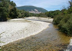
 The Buëch river near Sisteron
|
|
| Country | France |
|---|---|
| Regions | Auvergne-Rhône-Alpes, Provence-Alpes-Côte d'Azur |
| Departments | Drôme, Hautes-Alpes, Alpes-de-Haute-Provence |
| Communes | Sisteron |
| Tributaries | |
| - left | Petit Buëch |
| - right | Méouge |
| City | Sisteron |
| Source | Massif du Dévoluy |
| - location | Lus-la-Croix-Haute, Drôme, Auvergne-Rhône-Alpes, France |
| - elevation | 2,400 m (7,874 ft) |
| - coordinates | 44°41′07″N 5°48′46″W / 44.68528°N 5.81278°W |
| Confluence | Durance |
| - location | Sisteron, Alpes-de-Haute-Provence, Provence-Alpes-Côte d'Azur, France |
| - elevation | 470 m (1,542 ft) |
| - coordinates | 44°12′05″N 5°56′35″E / 44.20139°N 5.94306°E |
| Length | 85.2 km (53 mi) |
| Basin | 1,478 km² (571 sq mi) |
| Discharge | for Laragne-Montéglin |
| - average | 20.1 m³/s (710 cu ft/s) |
The Buëch (pronounced 'Bweesh', and also called Occitan: Buech in Occitan) is a river in southeastern France. It flows into the Durance river from the right side. In its upper part, it's sometimes called the Grand Buëch before it joins with the Petit Buëch river.
Contents
About the Buëch River
The Buëch river is about 85.2 km (53 mi) long. The area of land that drains water into the Buëch is called its drainage basin. This area is about 1,478 km2 (571 sq mi).
How Much Water Flows?
The amount of water flowing in a river is called its discharge. This is how much water passes a certain point in the river each second. The Buëch river's average discharge is 20.10 m3/s (710 cu ft/s) near Laragne-Montéglin. This measurement is based on data collected over 15 years.
The chart below shows how the average amount of water in the Buëch river changes throughout the year. As you can see, the river has more water in spring (March-May) and less in late summer and early autumn (July-September).

Average monthly discharge (m3/s) at Laragne-Montéglin
Where the River Flows
The Buëch river begins high up in the Massif du Dévoluy mountains. Its source is near a mountain pass called col de la Croix-Haute, in the town of Lus-la-Croix-Haute in the Drôme department. It starts at a very high elevation of about 2,325 m (7,628 ft).
From there, the river flows towards the southwest. It then enters the Hautes-Alpes department and continues flowing south. Finally, the Buëch river joins the Durance river near Sisteron, in the Alpes-de-Haute-Provence department.
The Buëch river passes through 3 departments and 23 towns (called communes) in 2 different regions of France:
- In the Auvergne-Rhône-Alpes region:
- Drôme: Lus-la-Croix-Haute
- In the Provence-Alpes-Côte d'Azur region:
- Hautes-Alpes: La Faurie, Aspres-sur-Buëch, Serres, Saint-Julien-en-Beauchêne, Laragne-Montéglin
- Alpes-de-Haute-Provence: Mison, Sisteron
Rivers Joining the Buëch
Smaller rivers or streams that flow into a larger river are called tributaries. Here are the main tributaries of the Buëch river:
|
Rivers joining from the left side:
|
Rivers joining from the right side:
|
Images for kids
-
The Buëch river near Aspremont
-
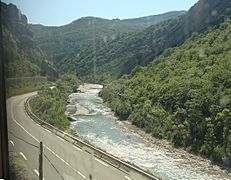
The Buëch river near Serres
-
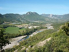
The Buëch river between Ribiers and Sisteron
-
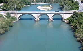
Where the Durance river (on the left) meets the Buëch river in Sisteron


More to Explore
See also
 In Spanish: Río Buëch para niños
