Cañas River (Ponce, Puerto Rico) facts for kids
Quick facts for kids Cañas River |
|
|---|---|

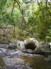
Cañas River in Ponce, Puerto Rico, crossing through Hacienda Buena Vista
|
|
| Commonwealth | Puerto Rico |
| Municipality | Ponce |
| Physical characteristics | |
| Main source | Cerro Avispa, Barrio Guaraguao 930 feet (280 m) 18°00′07″N 66°38′26″W / 18.0019106°N 66.6404508°W |
| River mouth | Rio Matilde 15 feet (4.6 m) |
| Length | 14 km (8.7 mi) |
| Basin features | |
| Progression | Guaraguao Magueyes Magueyes Urbano Canas Urbano |
| River system | Río Matilde |
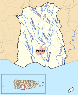
The Cañas River, also known as Río Cañas, is an important river in Ponce, Puerto Rico. It is sometimes called Río Magueyes in the area of Barrio Magueyes. This river is one of 14 rivers found in the municipality of Ponce.
Contents
Where Does the Cañas River Start?
The Cañas River begins its journey in a place called Cerro Avispa. This mountain is located in Barrio Guaraguao. It is close to the border with the town of Adjuntas. From there, the river flows south, heading towards the Caribbean Sea.
How People Used the River
Long ago, in the early 1900s, there was a large farm called Hacienda Buena Vista. This farm was in Barrio Magueyes. It was a coffee plantation that used the river's power. The river's water helped turn the machines that ground coffee beans. This was done using a clever system of water channels. Today, Hacienda Buena Vista is a museum.
The River's Journey to the Sea
The Cañas River flows south, running alongside a road called Puerto Rico route PR-123. This road used to be the main path from Adjuntas to Ponce.
As it continues south, the river enters the city of Ponce. It passes through an area known as Magueyes Urbano. The river then crosses near PR-132, a country road. This part of PR-132 is called Calle Villa Final.
The river then runs next to a neighborhood called Jardines del Caribe. It crosses a major road, Avenida Las Americas (PR-163). Further south, the Cañas River joins with another river, the Río Pastillo. When they meet, they form a new river called Río Matilde.
Less than a mile later, the Río Matilde flows into the Caribbean Sea. This happens at Barrio Playa. The government of Puerto Rico has plans to make the river's path straighter and wider. This process is called canalization.
What's Around the River?
Near the southern part of the Cañas River, there is a lot of limestone. This type of rock was perfect for building a cement factory. Because of this, a company called Ponce Cement was built close to the river.
Fish Life in the River
In 2008, scientists studied the fish living in the Cañas River. They found that the river's elevation changes as it flows. For example, about 5.6 kilometers northwest of Ponce, the river is about 220.8 meters high. Closer to Ponce, about 2.0 kilometers northwest, it is only about 30.0 meters high.
See also
 In Spanish: Río Cañas (Ponce) para niños
 | Chris Smalls |
 | Fred Hampton |
 | Ralph Abernathy |


