Calais Observatory facts for kids
Quick facts for kids |
|
|
Calais Observatory
|
|
 |
|
| Location | Meridian Park, North and Lincoln Streets, Calais, Maine |
|---|---|
| Area | 0.5 acres (0.20 ha) |
| Built | 1857 |
| NRHP reference No. | 12001069 |
| Added to NRHP | December 19, 2012 |
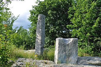
The Calais Observatory is a special place in Meridian Park in Calais, Maine. It has two large granite stones that were used a long time ago. These stones helped scientists make important measurements of the sky. They used them to figure out exactly where Calais was on Earth.
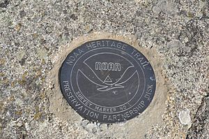
This was super important for mapping. The scientists wanted to know Calais's exact longitude. This meant finding its position compared to places like Cambridge, Massachusetts, and Greenwich, England. The site became a historic site in 2012. It's also part of a special program by the National Oceanic and Atmospheric Administration. In 1866, when its longitude was measured, Calais was one of the most accurately mapped places in the whole United States!
Contents
What is the Calais Observatory?
The Calais Observatory is located on a rocky hill inside Meridian Park. You can find it where North and Lincoln Streets meet. What's left of the observatory are two granite stones. There are also flat spots carved into the rock and some drill holes. In the past, the observatory had a small building to protect the equipment. But this building was gone by 1895.
The Transit Stone
One of the granite stones is shorter. It's called the transit stone. It stands about 3 feet 6 inches (1.07 meters) tall. It is 2 feet 7 inches (0.79 meters) wide and 2 feet (0.61 meters) deep. This stone is set up so its sides point exactly north, south, east, and west. The top of the stone has two carved channels. These channels helped line up a special telescope called an astronomical transit. This device helped measure when stars crossed the sky.
The Clock Stone
The other stone is taller and is called the clock stone. It is about 1 foot (0.30 meters) square at its base. It gets narrower towards the top, which is about 8 inches (0.20 meters) wide. This stone stands about 8 feet (2.44 meters) off the ground. It is located about 2 feet (0.61 meters) west of the transit stone. It has many grooves and holes carved into it. We don't know the exact purpose of this stone. But it looks like it was used to hold a special pendulum clock. Survey crews used these clocks to keep very accurate time. The clock would have been taken out of its case and placed directly on this stone. The transit stone was not designed to hold the clock.
Other Features at the Site
Besides the two main stones, there are other interesting things. There are rough square pads carved into the bedrock. These are about 4.5 feet (1.37 meters) north and south of the transit stone. There are also two holes drilled into the bedrock. These are 20 feet (6.10 meters) and 36 feet (10.97 meters) west of the transit stone. The exact reason for these features is not known.
Why was the Calais Observatory important?
For a long time, knowing a location's exact longitude was very important. It helped sailors navigate ships safely across the oceans. In the 1830s, the United States started the United States Coast Survey. Their job was to create accurate maps of the nation's coastline.
Measuring Longitude with Telegraphs
The Harvard College Observatory in Cambridge, Massachusetts, was chosen as the main starting point for these longitude measurements in 1847. Survey work then spread out from there. A new invention called the telegraph changed everything. It allowed scientists to send time signals instantly between far-apart places. This meant they could figure out the exact time difference between two locations. By watching when a star, like Polaris, crossed the sky at different places, they could use these time differences to calculate longitude very precisely.
On August 31, 1857, a survey team set up their equipment at the Calais site. They also set up equipment in Bangor, Maine. They measured Calais's longitude compared to Cambridge. This also helped them figure out the longitude of the observatory in Fredericton, New Brunswick.
Connecting to the World's Prime Meridian
Later, in 1858, the first telegraph cables were laid across the Atlantic Ocean. This made it possible to connect the United States' longitude measurements to the Greenwich Meridian. The Greenwich Meridian is the world's main longitude line, located in England. The first cable didn't work for long. But a second cable was successfully laid in 1866. This cable connected Valentia Island in Ireland to Heart's Content, Newfoundland.
In the summer of 1866, the longitudes of the Irish and Newfoundland stations were measured against Greenwich. Then, in December of that year, observations were made at Calais. This helped determine Calais's longitude compared to Greenwich. This important step allowed all the longitude maps of the United States to be connected with those of Great Britain. The observatory was used one more time in 1895. This was to get an even more precise longitude measurement compared to Cambridge.
Rediscovering the Stones
In 1998, the transit stone was found pushed over and leaning against a tree. The city moved it back to its original spot from 1857. In 2004, a surveyor from the U.S. National Geodetic Survey (the group that took over from the Coast Survey) checked the stone's location. They confirmed it was within 2 inches (5 centimeters) of where it was measured in 1866. This shows how important and accurate these old measurements were!
 | Roy Wilkins |
 | John Lewis |
 | Linda Carol Brown |


