
Calero Reservoir facts for kids
Quick facts for kids Calero Reservoir |
|
|---|---|

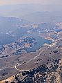
May 2009
|
|

Calero Reservoir
Location in California

Calero Reservoir
Location in the United States
|
|
| Location | Santa Clara County, California |
| Coordinates | 37°11′08″N 121°46′39″W / 37.18556°N 121.77750°W |
| Type | Reservoir |
| Primary inflows | Cherry Canyon, Pine Tree Canyon |
| Primary outflows | Arroyo Calero |
| Catchment area | 7.14 sq mi (18.5 km2) |
| Basin countries | United States |
| Managing agency | Santa Clara Valley Water District |
| Max. length | 2.2 mi (3.5 km) |
| Surface area | 349 acres (141 ha) |
| Water volume | 9,934 acre-feet (12,253,000 m3) |
| Surface elevation | 476 feet (145 m) |
Calero Reservoir is a large artificial lake in Santa Clara County, California. It is located in the Santa Teresa Hills. You can find it south of San Jose's Almaden Valley area. It is also north of the city of Morgan Hill. This reservoir is an important source of water for people living nearby.
Contents
Building Calero Reservoir
Calero Reservoir was created by building the Calero Dam. The dam was finished in 1935. It was built across a stream called Arroyo Calero, also known as Calero Creek.
How Water Flows Through Calero
The Calero Dam
The Calero Dam is made of earth. It is about 90 feet (27 m) tall and 840 feet (260 m) long. The top of the dam is 490 feet (150 m) above sea level. This dam helps hold back a lot of water.
Where the Water Comes From
Water flows into Calero Reservoir from different places. Some water comes from Cherry Canyon, which starts in the Santa Cruz Mountains. A small amount also comes from Pine Tree Canyon.
Calero Reservoir is one of the biggest reservoirs managed by the Santa Clara Valley Water District. This district helps provide water to the county.
In winter, the reservoir collects runoff from nearby hills. It also gets water from the Almaden Reservoir through a canal. Water can also come from Anderson Reservoir. This water travels through pipelines that are about 10.6 miles (17.1 km) long.
Why the Water is Stored
The water stored in Calero Reservoir is very important. It helps refill underground water supplies. It also goes to water treatment plants. There, the water is cleaned and then sent to homes in the county.
Making the Dam Stronger
In 2012, a study found that the ground under the dam could become soft during an earthquake. To keep everyone safe, the dam is being made stronger. This work was planned for 2021.
While the dam is being fixed, the reservoir cannot hold as much water. It is kept about 19 feet (5.8 m) below its full level. This means it can only hold about 45% of its total water. Once the dam is fully repaired, it will be able to hold almost its full amount of water again.
Where the Water Goes Next
Water from Calero Reservoir flows into Arroyo Calero. This stream then joins Alamitos Creek. Alamitos Creek flows into the Guadalupe River. Finally, the Guadalupe River empties into the southern part of San Francisco Bay.
Animals and Nature
Fish in the Reservoir
You can find different kinds of fish in Calero Reservoir. These include largemouth bass, common carp, and black crappie. These fish are not originally from this area.
Important Fish Safety Warning
The California Office of Environmental Health Hazard Assessment has an important safety message. They advise people not to eat any fish caught from Calero Reservoir. This is because the fish have higher levels of mercury. It's important to follow this advice to stay healthy.
Fun Things to Do
A large county park surrounds Calero Reservoir. It covers about 4,471-acre (1,809 ha). There are many fun activities you can do here:
- Fishing: You can fish, but it's catch-and-release only. This means you must let the fish go after you catch them.
- Picnics: There are places to have picnics with your family and friends.
- Hiking: You can explore the park on hiking trails.
- Horseback Riding: Some trails are also open for horseback riding.
You can also enjoy activities on the water. Boating, water-skiing, and jet-skiing are allowed. However, swimming is not permitted in the reservoir.
Images for kids
-
Calero Reservoir aerial view during the August 2021 wildfires' smoky air

