
California Historical Landmarks in Contra Costa County facts for kids
California is full of amazing historical places! Many of these special spots are called California Historical Landmarks. These are important sites that tell us about the past of our state. In Contra Costa County, located in Northern California, there are many such landmarks. They include old homes, natural wonders, and places where important events happened. Learning about them helps us understand the history of this area and the people who lived here long ago.
Contents
Exploring Contra Costa's Historic Places
Contra Costa County has many landmarks that show its rich history. From old homes to important natural sites, each one tells a unique story.
Historic Homes and Buildings
Many landmarks in Contra Costa County are old homes or buildings. These structures give us a peek into how people lived in the past.
Alvarado Adobe
The Alvarado Adobe is a historic building located in San Pablo. Adobes are traditional homes made from sun-dried mud bricks. This adobe helps us remember the early days of California.
Castro Home
The Castro Home is another important historic house. It is found in El Cerrito. This home is a reminder of the early families who settled in the area.
Don Fernando Pacheco Adobe
This adobe, located in Concord, is a very old and important building. It was once the home of Don Fernando Pacheco. This site is also listed on the National Register of Historic Places, which means it's recognized as important across the whole country!
.JPG)
Don Salvio Pacheco Adobe
Also in Concord, the Don Salvio Pacheco Adobe is another significant adobe. It belonged to Don Salvio Pacheco, who was an important figure in the area's history.

The Old Homestead
In Crockett, you can find The Old Homestead. This historic home gives us a look at what life was like in the past in this part of Contra Costa County.

Vicente Martinez Adobe
The Vicente Martinez Adobe is located in Martinez. This adobe was built in 1849. It is part of the story of the Martinez family, who were among the first settlers in the area.
_-_panoramio_(1).jpg)
Important Natural and Industrial Sites
Some landmarks are not just buildings but also natural places or sites important for their industry.
Captain Pedro Fages Trail
This landmark in Danville marks the trail of Captain Pedro Fages. He was an early Spanish explorer in California. His journeys helped map out new areas.

East Brother Light Station
The East Brother Light Station is a lighthouse located near Point San Pablo. Lighthouses are towers with bright lights that help guide ships safely at night or in bad weather. This lighthouse has been helping sailors for many years.

John Muir Home
In Martinez, you can visit the home of John Muir. He was a very famous naturalist and conservationist. He worked hard to protect America's wild places, like national parks. His home is now a national historic site.

Mount Diablo
Mount Diablo is a tall mountain that stands out in Contra Costa County. It's located within Mount Diablo State Park. This mountain is a significant natural landmark and offers amazing views of the surrounding area.

Mount Diablo Coal Field
The Mount Diablo coal field is located within the Black Diamond Mines Regional Preserve near Antioch. This area was once a very busy place where coal was mined. It tells the story of early industry and mining in California. It is also on the National Register of Historic Places.
.JPG)
Richmond Shipyards District
The Richmond Shipyards District in Richmond is a historic area. During World War II, many ships were built here very quickly to help with the war effort. This district played a huge role in American history and is also on the National Register of Historic Places.
.jpg)
Site of Giant Powder Company
This landmark is located at Point Pinole Regional Shoreline in Richmond. It marks the spot of an early factory that made gunpowder. This company was important for its time, though the original factory was in San Francisco.
Site of the Murder of Dr. John Marsh
This site in Martinez marks a sad event in history. It is where Dr. John Marsh, an early pioneer, was murdered. This landmark reminds us of the challenges and dangers faced by people in the early days of California.

Images for kids
-
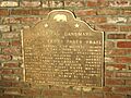
A marker for the Captain Pedro Fages Trail.
-
The historic Don Fernando Pacheco Adobe.
-
The Don Salvio Pacheco Adobe in Concord.
-
The East Brother Light Station, a historic lighthouse.
-
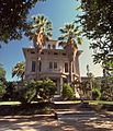
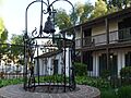
The historic home of John Muir.
-
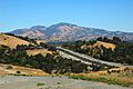
A view of Mount Diablo.
-
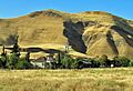
The entrance to the Black Diamond Mines Regional Preserve.
-
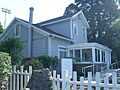
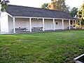
The Old Homestead in Crockett.
-
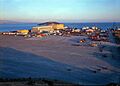
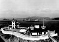
Richmond Shipyard No. 3, a historic site.
-
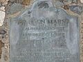
A marker at the site of Dr. John Marsh's murder.
-
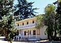
The Vicente Martinez Adobe.
