Calipatria, California facts for kids
Quick facts for kids
City of Calipatria
|
|||
|---|---|---|---|
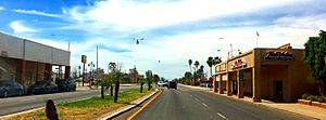
Downtown Calipatria at E. Main St. (CA SR 115) and N. Sorensen Ave. (CA SR 111)
|
|||
|
|||
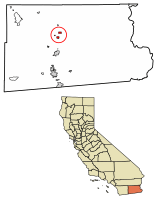
Location of Calipatria in Imperial County, California.
|
|||
| Country | United States | ||
| State | California | ||
| County | Imperial | ||
| Incorporated | February 28, 1919 | ||
| Area | |||
| • Total | 3.70 sq mi (9.58 km2) | ||
| • Land | 3.70 sq mi (9.58 km2) | ||
| • Water | 0.00 sq mi (0.00 km2) 0% | ||
| Elevation | -180 ft (−54.9 m) | ||
| Population
(2020)
|
|||
| • Total | 6,515 | ||
| • Density | 1,761.29/sq mi (680.12/km2) | ||
| Time zone | UTC-8 (Pacific (PST)) | ||
| • Summer (DST) | UTC-7 (PDT) | ||
| ZIP code |
92233
|
||
| Area codes | 442/760 | ||
| FIPS code | 06-09878 | ||
| GNIS feature IDs | 1652681, 2409962 | ||
Calipatria is a city in Imperial County, California. Its name is a mix of "California" and "Patria," which means "homeland" in Spanish. Calipatria is about 23 miles (37 km) north of El Centro. It is part of the El Centro Metropolitan Area.
In 2020, the city had a population of 6,515 people. This number includes about 4,000 people who live at Calipatria State Prison. The city is located along State Route 111.
Contents
Exploring Calipatria's Location and Climate
Calipatria is located at 33°07′32″N 115°30′51″W.
The Lowest City in the Western Hemisphere
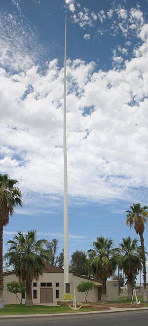
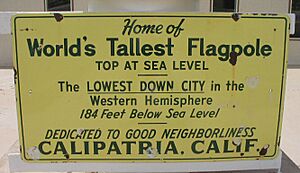
Calipatria is special because it is the lowest incorporated city in the Western Hemisphere. It sits 180 feet (55 meters) below sea level! To make sure their American flag always flies above sea level, the city has a very tall flagpole. This flagpole is 184 feet (56 meters) high.
The United States Census Bureau says that Calipatria covers a total area of 3.7 square miles (9.6 square kilometers). All of this area is land.
Calipatria's Hot Desert Climate
Calipatria has a hot desert climate. This means it gets a lot of sunshine all year. The weather is usually very warm or hot. On climate maps, this type of weather is called "Bwh."
| Climate data for Calipatria (180 feet below sea level) | |||||||||||||
|---|---|---|---|---|---|---|---|---|---|---|---|---|---|
| Month | Jan | Feb | Mar | Apr | May | Jun | Jul | Aug | Sep | Oct | Nov | Dec | Year |
| Mean daily maximum °F (°C) | 71.0 (21.7) |
74.0 (23.3) |
80.0 (26.7) |
86.0 (30.0) |
95.0 (35.0) |
103.0 (39.4) |
107.0 (41.7) |
107.0 (41.7) |
102.0 (38.9) |
91.0 (32.8) |
79.0 (26.1) |
70.0 (21.1) |
88.8 (31.5) |
| Daily mean °F (°C) | 56.0 (13.3) |
59.0 (15.0) |
64.5 (18.1) |
70.0 (21.1) |
77.5 (25.3) |
85.0 (29.4) |
91.0 (32.8) |
92.0 (33.3) |
86.0 (30.0) |
75.0 (23.9) |
63.5 (17.5) |
55.0 (12.8) |
72.9 (22.7) |
| Mean daily minimum °F (°C) | 41.0 (5.0) |
44.0 (6.7) |
49.0 (9.4) |
54.0 (12.2) |
60.0 (15.6) |
67.0 (19.4) |
75.0 (23.9) |
77.0 (25.0) |
70.0 (21.1) |
59.0 (15.0) |
48.0 (8.9) |
40.0 (4.4) |
57.0 (13.9) |
| Average precipitation inches (mm) | 0.48 (12) |
0.55 (14) |
0.33 (8.4) |
0.05 (1.3) |
0.02 (0.51) |
0.00 (0.00) |
0.08 (2.0) |
0.21 (5.3) |
0.16 (4.1) |
0.25 (6.4) |
0.19 (4.8) |
0.48 (12) |
2.80 (71) |
| Source: Weather Channel | |||||||||||||
A Brief Look at Calipatria's History
The area where Calipatria now stands was first settled in 1914. It was founded by the Imperial Valley Farm Lands Association. They called the town Date City. The first post office in Calipatria opened in the same year, 1914. Calipatria officially became a city in 1919.
Understanding Calipatria's Population
| Historical population | |||
|---|---|---|---|
| Census | Pop. | %± | |
| 1920 | 785 | — | |
| 1930 | 1,554 | 98.0% | |
| 1940 | 1,799 | 15.8% | |
| 1950 | 1,428 | −20.6% | |
| 1960 | 2,548 | 78.4% | |
| 1970 | 1,824 | −28.4% | |
| 1980 | 2,636 | 44.5% | |
| 1990 | 2,690 | 2.0% | |
| 2000 | 7,289 | 171.0% | |
| 2010 | 7,705 | 5.7% | |
| 2020 | 6,515 | −15.4% | |
| U.S. Decennial Census | |||
Population in 2010
In 2010, Calipatria had about 7,800 people. The city had a mix of different groups. About 64% of the people were Hispanic or Latino. The population included people who identified as White, African American, Native American, Asian, and Pacific Islander.
Many people lived in family homes. The average household had about 3.5 people. The average family had about 3.9 people.
The ages of the people in Calipatria varied. About 16% of the population was under 18 years old. About 48% were between 25 and 44 years old.
Population in 2000
In 2000, Calipatria had 7,289 people living in about 899 households. About 50% of these households had children under 18. The city was home to many families.
The population was diverse. About 57% of the people were Hispanic or Latino. There were also significant numbers of White and African American residents.
City Services and Transportation
Transportation in Calipatria
For moving goods, Calipatria has freight train service. This service is provided by the Union Pacific Railroad.
Utilities for Residents
The city of Calipatria gets its water from the Golden State Water Company. Electricity is supplied by the Imperial Irrigation District. Natural gas comes from Southern California Gas. Phone services are provided by Pacific Bell.
Famous Places to Visit in Calipatria
Salvation Mountain is a well-known place to visit north of Calipatria. It is close to Slab City. Salvation Mountain is a small hill that is completely covered in bright colors. It is made from thousands of gallons of acrylic paint, straw, concrete, and adobe. A man named Leonard Knight created it to share the message that "God Loves Everyone."
Salvation Mountain became even more famous after it was shown in the book Into the Wild. It was also in the 2007 movie based on the book. The music video for the song Fourth of July by Shooter Jennings also features Salvation Mountain.
Cities That Are Friends
Calipatria has a "sister city." This means they share a special friendship with another city.
 Brawley, California
See also
 In Spanish: Calipatria para niños


