Camargo, Kentucky facts for kids
Quick facts for kids
Camargo, Kentucky
|
|
|---|---|

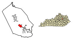
Location in Montgomery County, Kentucky
|
|
| Country | United States |
| State | Kentucky |
| County | Montgomery |
| Incorporated | April 28, 1969 |
| Government | |
| • Type | City Commission |
| Area | |
| • Total | 2.21 sq mi (5.73 km2) |
| • Land | 2.19 sq mi (5.67 km2) |
| • Water | 0.03 sq mi (0.07 km2) |
| Elevation | 922 ft (281 m) |
| Population
(2020)
|
|
| • Total | 1,020 |
| • Density | 466.39/sq mi (180.04/km2) |
| Time zone | UTC-5 (Eastern (EST)) |
| • Summer (DST) | UTC-4 (EDT) |
| ZIP Code |
40353
|
| FIPS code | 21-12052 |
| GNIS feature ID | 0488655 |
Camargo is a small city in Montgomery County, Kentucky, in the United States. It is known as a home rule-class city. In 2020, about 1,020 people lived there. Camargo is part of the wider Mount Sterling area.
The town got its name from soldiers who came back from the Mexican–American War. They might have named it after a place in Mexico called Camargo. Or, it could have been named after a Mexican entertainer with the same name. The town had a post office that was open from 1848 until 1963.
Contents
Exploring Camargo's Location
Camargo is located in the southern part of Montgomery County. You can find it at these coordinates: 37.999241 degrees north and 83.896203 degrees west.
Roads and Connections
U.S. Route 460 is a main road that goes right through Camargo. This road connects the city to other places.
- It leads northwest about 5 miles (8 km) to Mount Sterling. Mount Sterling is the main city and county seat of Montgomery County.
- It also goes southeast about 15 miles (24 km) to Frenchburg.
Land and Water Features
Camargo covers a total area of about 2.21 square miles (5.73 square kilometers). Most of this area is land. Only a small part, about 0.03 square miles (0.07 square kilometers), is water.
The city has some natural water features:
- Bowles Branch borders the city to the south.
- Greenbrier Creek flows through the northern part of the city.
Both of these streams flow into Slate Creek. Slate Creek then flows north into the Licking River. The Licking River eventually joins the Ohio River near Covington.
Camargo's Population Over Time
The population of Camargo has changed quite a bit over the years. Here's a quick look at how many people have lived there during different census years:
| Historical population | |||
|---|---|---|---|
| Census | Pop. | %± | |
| 1880 | 95 | — | |
| 1970 | 244 | — | |
| 1980 | 1,301 | 433.2% | |
| 1990 | 1,022 | −21.4% | |
| 2000 | 923 | −9.7% | |
| 2010 | 1,081 | 17.1% | |
| 2020 | 1,020 | −5.6% | |
| U.S. Decennial Census | |||
Population in 2000
According to the census from the year 2000, there were 923 people living in Camargo. These people lived in 362 households. About 275 of these households were families.
- About 33.1% of households had children under 18 living with them.
- Most households (62.2%) were married couples living together.
- The average household had about 2.55 people.
Age Groups in 2000
The population in 2000 was spread out across different age groups:
- 24.6% were under 18 years old.
- 10.3% were between 18 and 24 years old.
- 30.8% were between 25 and 44 years old.
- 22.6% were between 45 and 64 years old.
- 11.7% were 65 years old or older.
The average age of people in Camargo in 2000 was 35 years.
Education in Camargo
Camargo has a lending library for its residents. It is a branch of the Montgomery County Public Library system. This means people in Camargo can borrow books and other materials from the library.
See also
 In Spanish: Camargo (Kentucky) para niños
 | John T. Biggers |
 | Thomas Blackshear |
 | Mark Bradford |
 | Beverly Buchanan |

