Cameron, Missouri facts for kids
Quick facts for kids
Cameron, Missouri
|
||
|---|---|---|

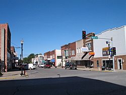
Downtown Cameron
|
||
|
||
| Nickname(s):
Crossroads of the Nation
|
||

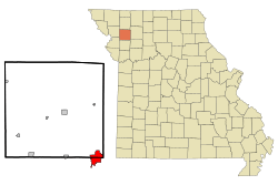
Location of Cameron, Missouri
|
||

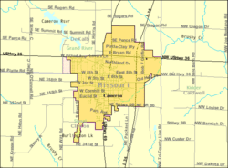
U.S. Census Map
|
||
| Country | United States | |
| State | Missouri | |
| Counties | Clinton, DeKalb, Caldwell | |
| Government | ||
| • Type | Council–manager | |
| Area | ||
| • Total | 7.13 sq mi (18.47 km2) | |
| • Land | 6.86 sq mi (17.77 km2) | |
| • Water | 0.27 sq mi (0.70 km2) | |
| Elevation | 1,011 ft (308 m) | |
| Population
(2020)
|
||
| • Total | 8,513 | |
| • Density | 1,240.42/sq mi (478.93/km2) | |
| Time zone | UTC-6 (Central (CST)) | |
| • Summer (DST) | UTC-5 (CDT) | |
| ZIP code |
64429
|
|
| Area code(s) | 816 | |
| FIPS code | 29-10828 | |
| GNIS feature ID | 2393723 | |
| Website | City of Cameron | |
Cameron is a city in Missouri, USA. It is special because it is located in three different counties: Clinton, DeKalb, and Caldwell. In 2020, about 8,513 people lived there. Cameron is also part of the larger Kansas City and St. Joseph metropolitan areas. This means it's connected to bigger cities nearby.
Contents
History of Cameron
How Cameron Started
In 1854, a man named Samuel McCorkle planned a town called Somerville. A railroad company, the Hannibal and St. Joseph Railroad, wanted to build tracks through the area. However, they said Somerville was too hilly for their trains.
So, in 1855, McCorkle planned a new town about 1.5 miles west. This new town became what is now Downtown Cameron. He named it Cameron after his wife, Malinda Cameron. All the buildings from Somerville were moved to the new Cameron. Today, McCorkle Park is still a main park in the city.
The Railroad's Impact
In the 1860s, there was a big race to decide where the first transcontinental railroad would begin. The Hannibal & St. Joseph Railroad was the farthest west train line at the time. Everyone wanted it to cross the Missouri River in their city.
Omaha, Nebraska won the right to start the railroad going west. But it didn't have a bridge to connect it to other train lines. Kansas City, Missouri convinced the railroad to build a special "Cameron Branch" line. This line bypassed other cities like St. Joseph.
The building of the Hannibal Bridge in Kansas City helped that city grow very quickly. Because of this new railroad connection, Cameron's population also grew a lot. It went from 100 people in 1859 to 3,000 people.
Cameron as a College Town
From 1883 to 1930, Cameron was home to a college. It started as the Cameron Institute and later became Missouri Wesleyan College. The Methodist Church ran the college.
After the college closed, one of its buildings became Cameron High School. This building was torn down in the 1960s. A new high school was built nearby. The old campus grounds are now used for parking near the football field.
Growth and Development
In the 1980s and 1990s, Cameron became more well-known. This was partly because a local resident, Bob F. Griffin, was a very important leader. He served for over 15 years as the Speaker of the Missouri House of Representatives.
During his time, he helped bring important projects to Cameron. These included the Missouri Veterans Home and the Western Missouri Correctional Center. The correctional center is now the city's largest employer, with 700 workers. A street in Cameron is named "Bob Griffin Road."
Cameron has continued to grow as new highways were built. The city has expanded north towards U.S. Route 36. It has also grown east towards Interstate 35.
Geography of Cameron
Cameron covers an area of about 6.30 square miles (16.32 square kilometers). Most of this area, about 6.04 square miles (15.64 square kilometers), is land. The rest, about 0.26 square miles (0.67 square kilometers), is water.
Unique Street System
More than two-thirds of Cameron is in Clinton County. This part includes the old downtown area, the high school, and the Veterans Home. The area north of a certain street (NE Platte/8th Street/County Road 56) is in DeKalb County. This northern part has correctional centers and shopping areas near U.S. 36.
Cameron also stretches east into Caldwell County. Because the city is in three different counties, its street names can be a bit confusing! For example, some streets in the northern DeKalb part might be called "Southeast Rogers Road." Streets in the southern Clinton County part might be "Northeast 358th Street."
These names continue the street system used in Kansas City. In Caldwell County, on the far east side, street names might start with "Northwest." It's even possible for a road to change its name from "Southeast Oregon Road" to "Northwest Oregon Road" as it crosses a county line just outside the city!
Cameron's Climate
| Weather chart for Cameron, Missouri | |||||||||||||||||||||||||||||||||||||||||||||||
|---|---|---|---|---|---|---|---|---|---|---|---|---|---|---|---|---|---|---|---|---|---|---|---|---|---|---|---|---|---|---|---|---|---|---|---|---|---|---|---|---|---|---|---|---|---|---|---|
| J | F | M | A | M | J | J | A | S | O | N | D | ||||||||||||||||||||||||||||||||||||
|
1.1
35
15
|
1.4
40
19
|
2.5
52
31
|
3.7
63
40
|
5.3
74
53
|
4.7
83
63
|
4.6
87
67
|
4.2
86
65
|
4.2
79
56
|
2.9
66
44
|
2.7
52
32
|
1.8
40
21
|
||||||||||||||||||||||||||||||||||||
| temperatures in °F precipitation totals in inches |
|||||||||||||||||||||||||||||||||||||||||||||||
|
Metric conversion
|
|||||||||||||||||||||||||||||||||||||||||||||||
Cameron has a humid continental climate. This means it has cold winters with snow and hot, humid summers. The weather can sometimes be extreme. Thunderstorms and tornadoes can happen in Cameron. Snow usually falls in winter. Late spring and early summer are the wettest times of the year.
| Climate data for Cameron, Missouri | |||||||||||||
|---|---|---|---|---|---|---|---|---|---|---|---|---|---|
| Month | Jan | Feb | Mar | Apr | May | Jun | Jul | Aug | Sep | Oct | Nov | Dec | Year |
| Record high °F (°C) | 72 (22) |
79 (26) |
86 (30) |
92 (33) |
97 (36) |
102 (39) |
109 (43) |
108 (42) |
100 (38) |
96 (36) |
82 (28) |
72 (22) |
109 (43) |
| Mean daily maximum °F (°C) | 35.1 (1.7) |
40.3 (4.6) |
52.1 (11.2) |
63.4 (17.4) |
73.6 (23.1) |
83.0 (28.3) |
87.3 (30.7) |
85.5 (29.7) |
78.5 (25.8) |
66.2 (19.0) |
51.5 (10.8) |
39.7 (4.3) |
63.0 (17.2) |
| Mean daily minimum °F (°C) | 15.1 (−9.4) |
19.1 (−7.2) |
30.7 (−0.7) |
39.9 (4.4) |
52.7 (11.5) |
63.1 (17.3) |
67.1 (19.5) |
64.9 (18.3) |
55.5 (13.1) |
43.9 (6.6) |
31.7 (−0.2) |
21.2 (−6.0) |
42.1 (5.6) |
| Record low °F (°C) | −27 (−33) |
−27 (−33) |
−17 (−27) |
7 (−14) |
25 (−4) |
34 (1) |
43 (6) |
40 (4) |
27 (−3) |
14 (−10) |
−10 (−23) |
−27 (−33) |
−27 (−33) |
| Average precipitation inches (mm) | 1.14 (29) |
1.40 (36) |
2.52 (64) |
3.72 (94) |
5.30 (135) |
4.69 (119) |
4.64 (118) |
4.22 (107) |
4.24 (108) |
2.91 (74) |
2.66 (68) |
1.76 (45) |
39.20 (996) |
| Average snowfall inches (cm) | 5.5 (14) |
8.2 (21) |
1.9 (4.8) |
0.4 (1.0) |
0.4 (1.0) |
0 (0) |
0 (0) |
0 (0) |
0 (0) |
0 (0) |
0.9 (2.3) |
4.4 (11) |
21.7 (55) |
| Source: NOAA | |||||||||||||
People of Cameron
| Historical population | |||
|---|---|---|---|
| Census | Pop. | %± | |
| 1870 | 1,428 | — | |
| 1880 | 2,109 | 47.7% | |
| 1890 | 2,917 | 38.3% | |
| 1900 | 2,979 | 2.1% | |
| 1910 | 2,980 | 0.0% | |
| 1920 | 3,248 | 9.0% | |
| 1930 | 3,507 | 8.0% | |
| 1940 | 3,615 | 3.1% | |
| 1950 | 3,570 | −1.2% | |
| 1960 | 3,674 | 2.9% | |
| 1970 | 3,960 | 7.8% | |
| 1980 | 4,519 | 14.1% | |
| 1990 | 4,831 | 6.9% | |
| 2000 | 8,312 | 72.1% | |
| 2010 | 9,933 | 19.5% | |
| 2020 | 8,513 | −14.3% | |
| U.S. Decennial Census | |||
Population in 2020
The 2020 United States census counted 8,513 people living in Cameron. There were 2,414 households and 1,338 families. The population density was about 1,241 people per square mile.
Most residents, about 84.98%, were white. About 8.08% were black or African-American. Other groups included Native American, Asian, and people of two or more races. About 3.6% of the population was Hispanic or Latino.
About 27% of households had children under 18. About 43.6% were married couples living together. The average household had 2.3 people. The average family had 2.9 people.
About 17% of the population was under 18 years old. About 15.6% were 65 years or older. The average age in Cameron was 36.4 years.
Population in 2010
In 2010, there were 9,933 people living in Cameron. The city had 2,605 households. The population density was about 1,644 people per square mile.
The racial makeup was similar to 2020. About 82.9% were White. About 14.8% were African American. Other groups included Native American and Asian people. About 2.0% of the population was Hispanic or Latino.
About 33.8% of households had children under 18. About 42.6% were married couples. The average household had 2.36 people. The average family had 3.04 people.
The median age in 2010 was 37.4 years. About 17.1% of residents were under 18. About 13.5% were 65 or older. For every 100 females, there were about 208.5 males in the city.
Getting Around Cameron
Major Roads
Cameron is connected by several important highways:
- Interstate 35: You can get on or off at exits 52 and 54.
- Interstate 72: There are plans to extend this highway to Cameron.
- U.S. Route 36
- U.S. Route 69
Bus Service
If you need to travel between cities, Jefferson Lines provides bus service to Cameron.
Education in Cameron
The Cameron R-I School District runs the schools in the city. There is one elementary school, one intermediate school, one middle school, and Cameron High School.
Cameron also has a public library. The Cameron Public Library has about 35,000 items you can borrow.
Famous People from Cameron
Some notable people have come from Cameron:
- Joseph Irwin France: A U.S. Senator who represented Maryland.
- Don Gillis: A talented composer and conductor.
- DeWitt Clarke Jennings: An actor.
- George Smith: A former lieutenant governor of Missouri.
See also
 In Spanish: Cameron (Misuri) para niños


