
Cape Borda, South Australia facts for kids
Quick facts for kids Cape BordaSouth Australia |
|||||||||||||||
|---|---|---|---|---|---|---|---|---|---|---|---|---|---|---|---|

Cape Borda Lighthouse
|
|||||||||||||||

Cape Borda
Location in South Australia
|
|||||||||||||||
| Population | 10 (2016 census) | ||||||||||||||
| Established | 2002 | ||||||||||||||
| Postcode(s) | 5223 | ||||||||||||||
| Time zone | ACST (UTC+9:30) | ||||||||||||||
| • Summer (DST) | ACST (UTC+10:30) | ||||||||||||||
| Location |
|
||||||||||||||
| LGA(s) | Kangaroo Island Council | ||||||||||||||
| Region | Fleurieu and Kangaroo Island | ||||||||||||||
| County | Carnarvon | ||||||||||||||
| State electorate(s) | Mawson | ||||||||||||||
| Federal Division(s) | Mayo | ||||||||||||||
|
|||||||||||||||
|
|||||||||||||||
| Footnotes | Distances Coordinates Climate Adjoining localities |
||||||||||||||
Cape Borda is a small area, or "locality," located in South Australia. It's found on the western side of Kangaroo Island. This area is about 192 kilometers (119 miles) southwest of Adelaide, the capital city of South Australia.
The name "Cape Borda" comes from the famous Cape Borda Lightstation, a lighthouse that helps ships navigate. The boundaries for this locality were officially set in 2002.
Exploring Cape Borda's Land
Cape Borda is used for two main purposes. One is for conservation, which means protecting nature. The other is for primary production, like farming or fishing.
Protecting Nature at Cape Borda
A big part of Cape Borda is dedicated to protecting its natural environment. These areas are called "protected areas." They include:
- Flinders Chase National Park
- Ravine des Casoars Wilderness Protection Area
- Cape Torrens Wilderness Protection Area
These places help keep the unique plants and animals of Kangaroo Island safe.
Roads and Access
The Playford Highway forms part of the southern border of Cape Borda. This road helps people travel to and from the area.
Historic Places to Discover
Cape Borda is home to several important historical sites. These places are listed on the South Australian Heritage Register, meaning they are protected for their historical value.
- Harveys Return Cemetery: This is a cemetery with a long history.
- Cape Borda Lighthouse: This historic lighthouse has guided ships for many years.
- Harveys Return Landing Site: This was once an important place where boats would land.
How Cape Borda is Governed
Cape Borda is part of different government areas. This helps manage the locality and its services.
- Local Government: It falls under the Kangaroo Island Council. This council handles local services like roads and waste.
- State Government: For state elections, Cape Borda is in the electoral district of Mawson.
- Federal Government: For national elections, it's part of the federal division of Mayo.
Images for kids
-
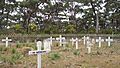
Harvey's Return cemetery
-
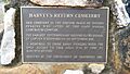
Harvey's Return plaque


