Flinders Chase, South Australia facts for kids
Quick facts for kids Flinders ChaseSouth Australia |
|||||||||||||||
|---|---|---|---|---|---|---|---|---|---|---|---|---|---|---|---|

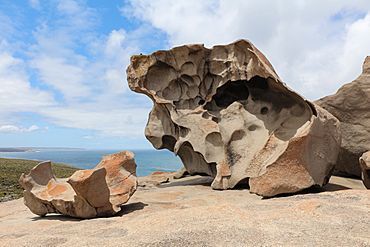
Remarkable Rocks
|
|||||||||||||||
| Population | 0 (2016 census) | ||||||||||||||
| Established | 2002 | ||||||||||||||
| Postcode(s) | 5223 | ||||||||||||||
| Time zone | ACST (UTC+9:30) | ||||||||||||||
| • Summer (DST) | ACST (UTC+10:30) | ||||||||||||||
| Location | 192 km (119 mi) south-west of Adelaide city centre | ||||||||||||||
| LGA(s) | Kangaroo Island Council | ||||||||||||||
| Region | Fleurieu and Kangaroo Island | ||||||||||||||
| County | Carnarvon | ||||||||||||||
| State electorate(s) | Mawson | ||||||||||||||
| Federal Division(s) | Mayo | ||||||||||||||
|
|||||||||||||||
|
|||||||||||||||
| Footnotes | Distances Coordinates Climate Adjoining localities |
||||||||||||||
Flinders Chase is a special place in South Australia. It is located on the south-western coast of Kangaroo Island. This area looks out over the Southern Ocean, which is also known as the Great Australian Bight in Australia.
Flinders Chase is about 210 kilometers (130 miles) south-west of Adelaide. Adelaide is the capital city of South Australia.
Discovering Flinders Chase
The name "Flinders Chase" was officially given to this area in 2002. It was named after the famous Flinders Chase National Park. This park is a big part of the area.
Where is Flinders Chase Located?
The northern edge of Flinders Chase is marked by the Playford Highway. The eastern side is bordered by the West End Highway in the north. Further south, the Sanderson Fire Access Track forms part of its eastern boundary.
Protecting Nature in Flinders Chase
The main purpose of the land in Flinders Chase is for conservation. This means protecting nature and wildlife. The entire area is covered by important protected areas.
- The southern part is home to the Flinders Chase National Park.
- The northern part includes the Ravine des Casoars Wilderness Protection Area.
These areas help keep the natural environment safe for plants and animals.
Exploring Historical Places
Flinders Chase has several important historical sites. These places are listed on the South Australian Heritage Register. They tell stories about the past.
- David Kilpatrick's Grave: This is the burial spot of a man named David Kilpatrick. He survived a shipwreck in 1899 but sadly died after reaching land.
- Rocky River Homestead: This was once a home or farm building. It shows how people lived long ago.
- Cape du Couedic Lighthouse: This lighthouse helped guide ships safely past the coast.
- Cape du Couedic Lighthouse Keepers' Cottages, Stable and Store: These buildings were where the lighthouse keepers lived and worked.
- Weirs Cove Jetty, Funnelway and Store Ruin: This area includes the remains of a jetty, which is like a small pier. It also has ruins of a funnelway and a store.
Government and Community
Flinders Chase is part of different government areas. These areas help manage the community and services.
- It is in the federal division of Mayo. This is for national government decisions.
- It is also in the state electoral district of Mawson. This is for state government decisions.
- Locally, it is part of the Kangaroo Island Council. This council helps manage local services and rules.
 | John T. Biggers |
 | Thomas Blackshear |
 | Mark Bradford |
 | Beverly Buchanan |


