Cape Horn (Washington) facts for kids
Quick facts for kids Cape Horn |
|
|---|---|

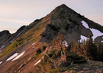
Northwest aspect from Ladies Pass
|
|
| Highest point | |
| Elevation | 7,316 ft (2,230 m) |
| Prominence | 516 ft (157 m) |
| Isolation | 0.91 mi (1.46 km) |
| Parent peak | Ladies Peak (7,708 ft) |
| Geography | |
| Location | Chelan County Washington state, U.S. |
| Parent range | Chiwaukum Mountains Wenatchee Mountains Cascade Range |
| Topo map | USGS Chiwaukum Mountains |
| Climbing | |
| Easiest route | Icicle Ridge Trail (#1570) + scrambling from Ladies Pass |
Cape Horn is a mountain in Washington state. It stands tall at 7,316-foot (2,230-metre) (about 2,230 meters) in Chelan County.
This mountain is located about 12 miles (19 km) west of the town of Leavenworth. It is part of the beautiful Alpine Lakes Wilderness. This area is managed by the Okanogan-Wenatchee National Forest. Cape Horn belongs to the Chiwaukum Mountains, which are a smaller part of the larger Cascade Range.
The closest taller mountain is Ladies Peak, about 0.9 miles (1.4 km) to the northwest. Grindstone Mountain is about 1.4 miles (2.3 km) to the south. Water from Cape Horn flows into Icicle Creek on the west side. On the east side, water drains into Chiwaukum Creek. Both of these creeks eventually flow into the Wenatchee River.
Even though Cape Horn is not the tallest mountain, it rises very steeply. It climbs over 4,300 feet (1,300 meters) from the Icicle Creek Valley in just about two miles. This mountain was given its name by Albert Hale Sylvester in 1909. He named it "Cape Horn" because of its sharp, pointed shape.
Weather Around Cape Horn
Most of the weather in this area comes from the Pacific Ocean. These weather systems travel east towards the Cascade Range. As they hit the tall mountains, the air is forced to rise. This causes the air to cool down and drop its moisture as rain or snow. This process is called Orographic lift.
Because of this, the Cascade Mountains get a lot of rain and snow. Winters are usually cloudy and snowy. However, in the summer, high-pressure systems over the Pacific Ocean often bring clear skies. The best time to visit or climb Cape Horn is usually from June through October. This is when the weather is most pleasant.
How the Mountains Were Formed
The Alpine Lakes Wilderness is known for its rugged and dramatic landscape. You can see jagged peaks, deep valleys carved by glaciers, and tall granite rock walls. There are also more than 700 mountain lakes scattered throughout the area.
Many years ago, huge geological events shaped this land. These events created the varied landscape and the big changes in elevation. This also led to the different climates you find across the Cascade Range.
During the Pleistocene period, which was over two million years ago, giant glaciers moved across the land. These glaciers advanced and then melted back many times. As they moved, they scraped away rock and left behind piles of debris. The last time the glaciers melted away from the Alpine Lakes area was about 14,000 years ago. By 10,000 years ago, they had moved north of the Canada–US border.
The "U"-shaped valleys you see today were carved out by these glaciers. The combination of the land being pushed up (called uplift) and cracks forming in the Earth's crust (called faulting), along with the glaciers, created the tall peaks and deep valleys of the Alpine Lakes Wilderness.
 | John T. Biggers |
 | Thomas Blackshear |
 | Mark Bradford |
 | Beverly Buchanan |


