Capital Pathway facts for kids
Quick facts for kids Capital Pathway |
|
|---|---|

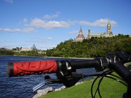
A section of the pathway on the Ottawa River just west of Parliament Hill
|
|
| Length | 220 km (140 mi) |
| Location | |
| Trailheads |
|
| Use | Walking, jogging, bicycling and dog walking |
| Sights |
|
| Hazards |
|
| Maintained by | National Capital Commission |
| Website | The Capital Pathway - National Capital Commission |
The Capital Pathway is a super long trail system in Canada. It's also called the Bike Path by many people. This amazing pathway is about 220 kilometers (137 miles) long! It connects many parks, rivers, and cool places in Ottawa, Ontario, and Gatineau, Quebec. Most of the pathway is paved, making it easy to use. It offers a nearly continuous route through the National Capital Region.
This pathway was mostly built by the National Capital Commission (NCC). The NCC is a special government organization created in 1959. The Capital Pathway includes several main trails. These are the Rideau Canal Pathway, the Ottawa River Pathway, and the Rideau River Pathway. The trails stretch out in all directions, reaching the edges of Ottawa and going north into Gatineau Park.
Contents
History of the Capital Pathway
The Capital Pathway was a big project by the National Capital Commission (NCC). The NCC was formed in 1959 to help improve the National Capital Region. Building these pathways was part of their plan.
The very first part of the pathway was the Ottawa River Pathway. It was built in the early 1970s. The NCC still takes care of most of the pathway today. In 2009, a section of the Ottawa River Pathway was paved. This part is between Acres Road and Moodie Drive.
Explore the Ottawa River Pathway
This very long pathway runs along the south side of the Ottawa River. It covers almost the entire length of the river within Ottawa. In the east, it goes all the way to the beach at Petrie Island. This is near Tenth Line Road and the Ottawa River.
As you head west, the pathway connects with the Aviation Parkway. This part is close to the Aviation Museum. Further along, it becomes part of the Trans Canada Trail, also known as The Great Trail. It winds through Rockcliffe Park. You'll pass the home of the Prime Minister at 24 Sussex Drive. You'll also see Rideau Hall, where the Governor General lives.
The path then goes past Major's Hill Park, which is near a bridge. It continues towards the back of Parliament Hill. From there, it connects to the pathways along the Rideau Canal. Moving westward, it passes the Canadian War Museum in LeBreton Flats. It then goes to Westboro Beach, then Brittania Beach, and past Moodie Drive. The pathway ends at Shirleys Bay.
Discover the Rideau Canal Pathway
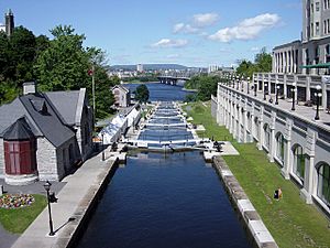
The most famous part of the Capital Pathway is the Rideau Canal section. It's right in downtown Ottawa. This makes it very popular with both tourists and local residents. People love to walk, cycle, and run here.
It's also popular in winter! The Rideau Canal is known as one of the longest skating rinks in the world. You can often skate for 6 to 8 kilometers (3.7 to 5 miles) in January.
The pathway's most northern point is where the canal flows into the Ottawa River. Right next to the locks is the Bytown Museum. There are actually two separate paths, one on each side of the canal. One path goes all the way around Dow's Lake. Pathway users often cross to the other side near Carleton University, just south of the lake.
The trail continues to Hog's Back Falls, where you can also cross. This is where the canal meets the Rideau River. The trail then continues on the east side of the Rideau River until Mooney's Bay Park. South of Mooney's Bay, the path starts again. It continues all the way to Ottawa's southern border.
Journey on the Rideau River Pathway
This pathway is not as well known by tourists, but local residents use it often. It starts at Rideau Falls, where the Rideau River meets the Ottawa River. It goes south through New Edinburgh. Then it follows Riverside Drive until it reaches Billings Bridge. There's a park here where you can often see ducks.
From Billings Bridge, the path continues south. It eventually meets up with the Rideau Canal at Hog's Back Falls. The more popular part of this pathway is on the east side of the Rideau River.
Other Pathways in Ottawa
Besides the main Rideau Canal, Ottawa River, and Rideau River Pathways, several other trails are part of the Capital Pathway system in Ottawa:
- Watts Creek Pathway
- Pinecrest Creek Pathway
- Experimental Farm Pathway
- Aviation Pathway
- Greenbelt Pathway
Pathways in Gatineau
Aylmer, a part of Gatineau, has a good network of bicycle paths. These paths go around the central area and pass by many beautiful spots. You can see places like the Aylmer Marina and the Deschênes Rapids.
The bike trail gets very steep as it goes north into Gatineau Park. Pink Lake is directly on the path. Other lakes, like Kingsmere Lake, are also easy to reach. The Champlain Lookout offers an amazing view of the lands west of Ottawa from a high point.
Safety on the Pathways
The National Capital Region is a very safe place. However, it's still important to pay attention to safety on the pathways. The pathways are not lit at night, so it can be very dark. There are also places where you might need to cross busy traffic.
The Pathway patrol is a group of volunteers in Ottawa, Ontario. These trained volunteers ride bikes, rollerblade, or walk along Ottawa's pathways. Their goal is to encourage active living, make the paths safer, and help everyone be polite to each other. They patrol many areas, including the NCC pathways in the west from Andrew Haydon Park to Britannia Park. They also patrol east along the Ottawa River Pathway to Petrie Island. The Rideau Canal (from downtown to Mooney's Bay) and the Rideau River (from Sussex Drive to Mooney's Bay) are also patrolled. They also cover some City of Ottawa parks in the Greenboro area. In 2010, the area of Kanata was added to their patrol region.
 | Laphonza Butler |
 | Daisy Bates |
 | Elizabeth Piper Ensley |


