Carbon, Iowa facts for kids
Quick facts for kids
Carbon
|
|
|---|---|
 |
|

Location of Carbon, Iowa
|
|
| Country | |
| State | |
| County | Adams |
| Township | Douglas |
| Area | |
| • Total | 0.75 sq mi (1.94 km2) |
| • Land | 0.75 sq mi (1.94 km2) |
| • Water | 0.00 sq mi (0.00 km2) |
| Elevation | 1,119 ft (341 m) |
| Population
(2020)
|
|
| • Total | 36 |
| • Density | 48.00/sq mi (18.53/km2) |
| Time zone | UTC-6 (Central (CST)) |
| • Summer (DST) | UTC-5 (CDT) |
| ZIP code |
50839
|
| Area code(s) | 641 |
| FIPS code | 19-10585 |
| GNIS feature ID | 2393738 |
Carbon is a very small community, known as a hamlet, located in Adams County, Iowa, United States. In 2020, only 36 people lived there. It is one of the smallest places in Iowa by population.
Today, Carbon has a church and a community center. There are no other businesses or services. The United States Census Bureau officially includes Carbon as a census-designated place.
Interestingly, other places in Iowa have also been named Carbon. For example, there was a Carbon Post Office in Davis County in 1881. Another Carbon Post Office existed in Webster County from 1870 to 1872.
Contents
The Story of Carbon
Carbon is located near the Middle Nodaway River. Long ago, this area was home to Native American tribes like the Pottawatomie, Oto, and Iowa. In 1851, a treaty led to these tribes moving to areas now known as Kansas or Oklahoma.
The first settler in Carbon was Elijah Walters, who arrived in 1849. He built a sawmill on the Middle Nodaway River. This mill became an important gathering spot for people in the area.
From Walters to Carbon
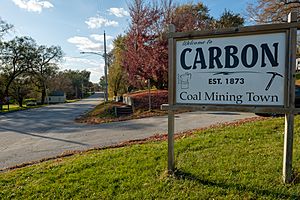
The village was first named Walters, after Elijah Walters. But then, coal was discovered nearby, and the name was changed to Carbon. The town was officially started in 1873. It became an incorporated town in 1903. A post office opened in Carbon in 1874, but for a few years (1877-1880), it was called Shinn.
Coal Mining Days
By the time of the Civil War, small coal mines were operating along the riverbanks near Carbon. In 1894, there were nine coal mines in Carbon, with five of them actively working. These mines typically went about 80 feet deep. They dug out a coal layer that was 12 to 20 inches thick. Carbon was known as a mining camp back then.
Unlike most coal camps in Iowa, Carbon did not have a local union for miners between 1900 and 1912. During this time, many other Iowa coal camps were unionized.
By 1908, it was estimated that the county had produced over 350,000 tons of coal. Most of this came from the Carbon area. The coal was sold locally and to towns up to 25 miles away. Two important mines in 1908 were the Jones, Smith and Tindall mine and the J.F. Ruth mine. These mines used horse-powered hoists and had very basic safety features.
The coal mining boom in Carbon lasted for about 75 years, from the late 1800s to the early 1900s. For a long time, the only water supply for Carbon came from a hand pump on "pump road." This pump has been there for over 100 years. People used horse-drawn wagons to bring ice from the river and water from the pump back to town. It wasn't until the late 1990s that modern water pipes were installed in Carbon.
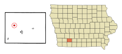
Where is Carbon?
Carbon is located on the south side of the Middle Nodaway River. It's just east of where the Middle Nodaway River meets Bull Creek.
The United States Census Bureau says that Carbon covers an area of about 0.71 square miles (1.94 square kilometers). All of this area is land.
How Many People Live Here?
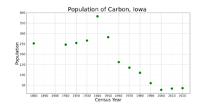
The number of people living in Carbon has changed a lot over the years. Here's a look at the population from different census years:
| Historical populations | ||
|---|---|---|
| Year | Pop. | ±% |
| 1880 | 252 | — |
| 1910 | 246 | −2.4% |
| 1920 | 254 | +3.3% |
| 1930 | 266 | +4.7% |
| 1940 | 383 | +44.0% |
| 1950 | 282 | −26.4% |
| 1960 | 162 | −42.6% |
| 1970 | 135 | −16.7% |
| 1980 | 110 | −18.5% |
| 1990 | 60 | −45.5% |
| 2000 | 28 | −53.3% |
| 2010 | 34 | +21.4% |
| 2020 | 36 | +5.9% |
| Source: and Iowa Data Center Source: |
||
2020 Census Details
In 2020, there were 36 people living in Carbon. These people lived in 16 households, and 10 of those were families. The population density was about 48 people per square mile.
Most residents (86.1%) were White. A small number were Black or African American (2.8%), Native American (2.8%), or Asian (2.8%). About 5.6% of the population identified as Hispanic or Latino.
The average age in Carbon was 57.5 years. About 13.9% of residents were under 20 years old. Many residents, 36.1%, were 65 years old or older. The population was almost evenly split between males (52.8%) and females (47.2%).
2010 Census Details
In 2010, Carbon had 34 people living there in 18 households. The population density was about 47.9 people per square mile. Most residents (97.1%) were White, and 2.9% were Native American. About 2.9% of the population was Hispanic or Latino.
The average age in 2010 was 50 years. About 17.6% of residents were under 18. Many residents, 47.2%, were between 45 and 64 years old. The gender breakdown was 55.9% male and 44.1% female.
Schools in Carbon
Students in Carbon attend schools within the Corning Community School District. For high school, students go to Southwest Valley High School. This school is operated by the Corning district and also serves students from the Villisca Community School District.
See also
 In Spanish: Carbon (Iowa) para niños
 | Roy Wilkins |
 | John Lewis |
 | Linda Carol Brown |


