
Carnewas and Bedruthan Steps facts for kids

Carnewas and Bedruthan Steps is a beautiful part of the Cornish coastline in the United Kingdom. It's located between the towns of Padstow and Newquay. The name Carnewas comes from a Cornish phrase meaning "rock-pile of summer dwelling," and Bedruthan means "Red-one's dwelling."
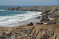
This area is partly owned by the National Trust, a charity that looks after special places. They have a shop and a café here. Many people visit to see the amazing cliff-top views and the unique rock formations on Bedruthan beach. It's also a popular spot for artists to paint.
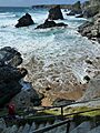
You can enjoy walks along the South West Coast Path here. There are also steep steps that lead down to the rocky beaches when the tide is low. However, it's very important to know that these beaches are not safe for swimming. Signs warn visitors about strong rip currents, fast tides, and hidden rocks underwater. In February 2020, a rockfall damaged the lower steps, so they are currently closed for safety.
Contents
A Look Back in Time: History of Bedruthan Steps
People have lived in this area for a very long time, even since the Bronze Age. This was thousands of years ago! We know this because there are six ancient burial mounds, called barrows, nearby.
Ancient Forts and Standing Stones
Overlooking Bedruthan Steps is a place called Redcliff Castle. This isn't a castle with stone walls like you might imagine, but an ancient fort from the Iron Age. It has three big earth walls and two ditches that were dug to protect it. Over time, the sea has worn away some parts of this old fort. There are also two other similar forts nearby at Park Head and Griffin's Point. These "cliff castles" or "promontory forts" were likely places where people lived all the time, not just for defense.
In 2009, a large standing stone, also known as a menhir, was found lying on its side near the coastal path. It's about 9 feet (2.7 meters) long!
Mining for Metals
Evidence of mining can be seen on the cliffs at Trenance Point and above the beach at Carnewas. The Carnewas mine started in 1855. Miners dug for different metals like lead, silver, copper, antimony, and nickel. These metals were found in veins, or "lodes," in the rocks.
The mine stopped working in 1863 but reopened in 1868 to dig for iron. It closed for good in 1874. The National Trust shop you see today was once the mine's office, and the café was another mine building.
How Bedruthan Steps Got Its Name
The name "Bedruthan Steps" is quite new, probably from the late 1800s. It's said to come from a giant named Bedruthan, who supposedly used the large rocks on the beach as stepping stones. This story was likely made up for Victorian tourists. The first time the name was written down was in a newspaper in 1847. It probably referred to one of the staircases miners used to get to their workings, but now it means the whole beach.
The Famous Sea Stacks
Each of the tall rock formations, called sea stacks, on the beach has a name. From north to south, they are Queen Bess, Samaritan Island, Redcove Island, Pendarves Island, and Carnewas Island.
- Queen Bess was named because it looked like Queen Elizabeth I. Sadly, the "head" of the rock was lost in a storm in 1981.
- Samaritan Island is named after a ship called the Good Samaritan. This ship was wrecked there in October 1846, and nine people lost their lives. A poem from that time tells how the ship was carrying food and supplies.
Nature and Geology at Bedruthan Steps

The coastline from Carnewas to Stepper Point is part of the Cornwall Area of Outstanding Natural Beauty. This means it's a very special landscape that is protected. Bedruthan Steps and Park Head is also a Site of Special Scientific Interest (SSSI). This area is important for its unique rocks and the plants and animals that live there. It's known for its slate rocks and fossils from the Middle Devonian period, which was about 386 to 377 million years ago! Rare fish fossils have also been found here.
Coastal Plants
The clifftops here face strong winds from the west, so only tough, low-growing plants can survive. You can find beautiful flowers like Bird's foot trefoil, Kidney vetch, Sheep’s-bit, and Spring squill. There are also plants that love the sea air, such as Sea Pink (Thrift) and Sea Campion.
Amazing Geology
The main rock at Bedruthan Steps is made of layers of sandstone, siltstone, and mudstone. These rocks are called the Bedruthan Formation. The huge sea stacks you see today were formed by the ocean wearing away the softer rocks, leaving the harder ones standing tall.
Scientists have found fossils of fish, corals, and trilobites in the slate rocks on Samaritan and Pendarves Islands. These fossils help us learn about ancient life. At the end of Park Head, there's a different type of rock called Diabase, which formed from magma deep underground.
A Place to See the Stars
In 2014, the area around Bedruthan Steps was given "Dark Sky" status. This means it's a great place to see the stars because there's very little light pollution. On a clear night, you can get amazing views of the stars and even the Milky Way galaxy!
Images for kids
-
The Bedruthan Steps
-
Bedruthan Steps from halfway point
